Monday, February 17, 2025

Mount St. Helens and Lupine Fields

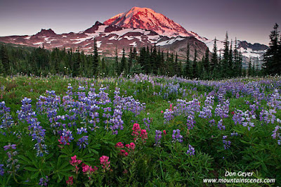
Image of Mount St. Helens and Lupine
Mount St. Helens above lupine meadows.
 Mount St. Helens is a great destination for flowers in season.  In fact, its season runs much earlier than, say, Mount Rainier. If this is what you are looking for, early to mid-July is the time to visit.  Basically, you have three choices:

  • The south side up FS 81 out of Cougar, WA.
  • Johnston Ridge at the end of SR 504 (from I-5).
  • Windy Ridge from FS25 & 99 out of Randle.
The south side of the mountain is the "non-eruption" view.  For most, it's the climbing side to the summit.  The views are of the "flat" summit (no crater).

Johnston Ridge is the most popular as it is a paved highway all the way to road's end at the Johnston Ridge Observatory.  It includes paved walkways and an amphitheater for easy viewing of the destruction side of the mountain, with flower meadows at your feet in season.  It, of course, also has the visitor center (with another one along the way at Coldwater). (Note as of this writing, 504 is closed just beyond the Coldwater Visitor Center due to road washout.)

Windy Ridge, while still fairly popular, involves a little more travel.  It's approached by heading south from Randle, WA. and following the signs for Windy Ridge.  The Windy Ridge area, while still accommodating for the casual visitor, is more of a hiking destination.  There is no visitor center, and the best floral views involve exploring the trails in the area.  Norway Pass and Independence Ridge are popular trails offering flower meadows and can be made into a loop trip with a second vehicle.  Of course, Norway Pass offers the spectacular view of the mountain over Spirit Lake!

The image above was taken along the Loowit Trail, approached via the Truman Trail from the Windy Ridge Viewpoint.  The fields of lupine were magnificent during this visit, and their perfume the strongest I have ever witnessed.  I made a loop trip for this visit, first visiting the Plains of Abraham, then descending the Windy Trail down into the meadows along the Loowit Trail before climbing the Windy Trail back up to the Truman Trail and returning to Windy Ridge.

This image was recently licensed for worldwide web usage by a prominent marketing company.  You can see many more images like this in my Mount St. Helens Gallery if you wish.

As always, thanks for looking!  Hope to see you on the trail!

Thursday, February 6, 2025

Enchanted Valley, Olympic National Park

Image of Quinault River from Pony Bridge
The Quinault River from Pony Bridge.

As you might know, Enchanted Valley is one of the most popular destinations in Olympic National Park, which I’ve always found interesting.  Not because it isn’t a worthwhile trip, but why it is.  I don’t find it overly scenic quite honestly (except Pony Bridge early on the trek), especially late in season.  The valley is wide and vegetation is predominantly grass and brush due to its low elevation, affording early season access (even year-around some years).  If you like sub-alpine meadows, you won’t find them here (but you will further up the valley in the summer months). Of course, it also offers the wild Quinault River, which changes its course often and has forced the relocation of the chalet.   In early season there are waterfalls cascading down the face of Chimney Rock and the Burke Range high above.  They’re nice.  They certainly bring character and enjoyment to the valley in early season. However, I never found them very photogenic as a stand-alone subject, even under desirable conditions (cloudy and overcast).  In my opinion, they make a great backdrop to accompany other subject matter to help tell the story (example below).

What the area does offer (not solitude), is wildlife!  Elk, bears, deer and more are extremely common in this area and often make themselves available, especially in the morning and evening.  For me, this is the highlight!

A black bear in the Enchanted Valley, Olympic National Park, Washington, USA
Black bear, Enchanted Valley.
I first discovered this area in the mid-1990’s.  I visited in mid-May, making sure to beat any Memorial Weekend crowds.  Backcountry permits were self-issued at the Quinault Ranger station – no line.  I shared the valley with one other person.  In two subsequent visits shortly thereafter, I had it all to myself.  I doubt you will ever experience such solitude today.  Now permits must be reserved in advance and there is a quota which is often met.

The fond memories I have of that first visit was sitting around camp and being surprised to see not one, not two, but three separate bears appear across the meadows from me, grazing.  I was nervous at first and wondered if I would have to protect my tent and belongings (my food was hung), but soon realized they didn’t care about my presence at all.  I had never experienced such a thing.

Image of Roosevelt Elk in Enchanted Valley, Olympic National Park, Washington, USA
Roosevelt Elk, Enchanted Valley.

I stayed a couple of days exploring the area, but mostly just watched the bears.

Then the day of departure arrived, and it was time to pack up and move out.  I was sad to leave, but didn’t realize the biggest moment of my trip awaited me.  As I wandered carefree down the trail past Pyrites Creek lost in my thoughts, I came around a bend to find a sight I never would have imagined – a bear a short distance off the trail sleeping on its back with all four feet in the air!  I parked myself a safe distance away and watched it sleep and even listened to it snore a couple of times!  It eventually opened an eye, saw me, and went back to sleep!  After a while it began getting restless and started rolling on either side, whichever was more comfortable.  The nap became short and soon it decided it was time to wander up the trail in the direction I had come, seemingly still somewhat groggy.  I could not believe what I had just experienced!  This experience reaffirmed that I would be back!

Camp below waterfalls in Enchanted Valley, Olympic National Park, Washington, USA
Camp below the waterfalls of Enchanted
Valley.

Of course, that experience never repeated itself.

Fast forward to 2023, when I returned once again in hopes of seeing my “friends”.  How different things were.  As mentioned above, permits can be much more challenging to come by, and the crowds were ever-present from beginning to end.  There was no solitude.  Fortunately, however, my “friends” were indeed there, seemingly waiting for me (hey, I can dream!).

So, for logistic planning, here is my take and input on this trip:

It’s a long trek – 13.3 miles to Enchanted Valley.  It’s very pleasant hike to take your mind off the work, but typical of Olympic National Park trails, much up and down.  Many people consider breaking the approach up into two days.

After crossing Graves Creek near the trailhead, the trail follows an abandoned road for 2.4 miles, climbing over a ridge and then descending steeply down to the crossing of the East Fork Quinault and Pony Bridge.  It’s a high bridge with the river far below as its plunging waters negotiate a deep gorge.  This is one of the most spectacular places along this entire trail in my opinion, and you will want to spend some time to enjoy!  There is a camp on the far side that I’ve always thought would be fun to enjoy.

Black bear sleeping near Pyrites Creek, Olympic National Park, Washington, USA
A sleeping black bear near the trail at Pyrites Creek.

From here the way continues mostly in forest, with many creek crossings and ups and downs as it traverses terraces and moraine.  There are a few trail washouts that must be negotiated.  Nothing too difficult though.  I call them speed bumps in the trip!

There are camps all along the trail as you head up the valley – typical of the Olympics.  Many you won’t find on a map.

Black bear in Enchanted Valley, Olympic National Park, Washington, USA
Black bear in Enchanted Valley

Pyrites Creek is reached at about 10 miles and is a nice place to stay.  Others obviously think so too!  It too has high wildlife traffic and is within a short distance of visiting Enchanted Valley on a leisurely visit, 3.5 miles further.

After crossing through a gate (yes, a gate), you are close to the bridge crossing of the river and your arrival to Enchanted Valley.  In case you are reading older guide books, the suspension bridge is long gone, having been washed out.  The current bridge requires a bit of attention as it is simply a log that has been flattened on the top for walking and has a single upstream handrail, high above the raging Quinault River.  You would not want to fall here.  After a long day of backpacking and tired legs, this definitely gets your attention!

Black bear in Enchanted Valley, Olympic National Park, Washington, USA
Black bear in Enchanted Valley

Photography Tips

Overcast days and even fog are the best days to visit this area for photography.  I find myself using my 70-200mm lens the most by far here, often coupled with 2x teleconverter for the wildlife.  A 24-70mm lens is worth carrying if you plan to shoot landscapes.  You might want to decide if the weight of a wide-angle is worth carrying on this long of a trek.  I would probably leave it at home if you are not toting an RF lens.

The Enchanted Valley Chalet circa 2002, Olympic National Park, Washington, USA
Enchanted Valley Chalet, circa ~2002.
Enchanted Valley is deep, so the harsh light comes quickly in the morning and lasts all the way to sunset.  There is not much, if any transition.  This is not a location most people will be banking on “golden hour” photography.

The season depends on your itinerary.  Spring is great for wildlife as the snow up higher keeps them in the valley.  Once the snow melts above, the animals see it as an invite to seek higher ground.  It’s also the best time to enjoy the waterfalls, which all but dry up later in the year.  If you wish to continue, the Anderson Pass area and LaCrosse Basin are fabulous places to visit beginning in mid-July most years.

Black bear in Enchanted Valley, Olympic National Park, Washington, USA
Black bear in Enchanted Valley

I hope you have found some of this information helpful in planning your own trip.  The adventure can be as long as you want it to be!  I would definitely budget no less than 3-4 days for it - more if you intend to extend the trip further towards LaCrosse Basin or Anderson Pass.

If you wish to seem more images from this wonderful park, please visit my Olympic Gallery.

As always, thanks for looking.  Hope to see you on the trail!


Sunday, January 26, 2025

Almost Daffodil Season!

That's right.  It's almost daffodil season here in the Pacific Northwest!  The season typically begins in early March in the Skagit Valley, painting the fields in a wide variety of colors, but predominantly yellow.  They are the precursor to the tulips, which will begin to arrive in early April.

But back to the daffodils.  They don't receive nearly the crowds that the tulips generate.  I think there are several reasons behind this.  The tulips are the more famous flower and have a festival built around them.  They are the highlight of the Roozengaarde gardens, with so many different varieties and colors.  The daffodils appear in them too, as seen in this photo.  However, they mostly seem to play a complimentary roll.

March can also be a challenging time to visit due to weather.  The fields can be wet and muddy, and snow is still a real possibility.  The temperatures can be cold.  Still, there are often nice weather windows to jump at the opportunity for a visit.  To visit the fields is free and Roozengaarde offers a map on their website which shows the locations (the fields vary year-to-year, as they don't plant consecutive years), and the current bloom situation.

The image above is from their garden, which requires an admission fee (well worth it).  I'm proud to share that it currently appears on a UK 2025 wall calendar.

You may view this and many other daffodil images in my Daffodils - Skagit Vallery Gallery.

As always, thanks for looking!  Maybe I'll see you there!

Sunday, August 18, 2024

Visiting An Old Friend - Mt. Olympus


Morning alpenglow on Mount Olympus
Morning alpenglow on Mount Olympus.
Mount Olympus is one of the more magical places to visit and experience in my home state of Washington. It's special in its uniqueness of low sprawling glaciers, remoteness, and isolation.  It's not a mountain you can drive to. In fact, I know of only two places you can see it from pavement - Hurricane Ridge in the far distance, and SR 110 near La Push.

Instead, one must venture on foot, approximately 18 miles each way to this viewpoint (36 miles round trip) to the moraine of the Blue Glacier, the prominent glacier in the forefront of these images, for this view.  It's an amazing view in person that images do not do just, in my opinion.

However, the trek into this mountain is just as much about the journey as it is the final destination.  It begins at 578' in a temperate rain forest and climbs through many ecosystems in its climb to the base of the mountain at ~5,000'.  Each has something special to offer.

As many times as I've done this trip, my itinerary was much different this time.  You see, I've climbed Mt. Olympus many times, always having set a high camp on Snow Dome or Panic Peak.  In fact, I've only stayed at Glacier Meadows, the popular base camp for the climb, once.  It was on my last climb and during our decent when our sole focus was on the long trek out.  There was no interest in climbing 800' back up to the moraine with such a long day ahead!  As such, I never had the opportunity to photograph this view from the moraine.

Image of Mount Olympus
Mount Olympus illuminated by the moon.
This was about to change.

After the long backpack into Glacier Meadows, I hiked up to the Moraine to scout it for the following morning as I would be traveling in the dark for sunrise.  It was mostly as I remembered it.  I spent a good part of the afternoon soaking it all in.  Incredible.  

As a bonus, I was surprised to see an old friend ascending up the trail - Dave Skinner!  Dave is a local icon for all his dedication to the Olympic Mountains over the years.  He lives outside of Port Angeles, off the grid, and hitchhikes to trailheads to perform volunteer trail maintenance.  He was on his annual trip up to the research hut on Snow Dome for the next week, which is where I first met him many years ago.  We visited for over an hour, catching up on just about everything.  This pleasant surprise made my day.

Dave Skinner on Blue Glacier Moraine.
I set my alarm for 3 am the next morning and was on the trail by 3:20. I arrived atop the moraine at 4:20 for a 5:30 sunrise.  Lots of time to fine-tune composition ideas and also catch the moon illuminating Mt. Olympus!

Sunrise light was delayed at first, presumably due to clouds or smoke to the east.  But it gained traction in short time and did not disappoint.  I played with several compositions, including features atop the moraine as forefront material.  But in the end, the Blue Glacier with all its immensity was my favorite.

The end of the shooting hour came much too quickly, as it often does, and I found myself having to say goodbye to this beautiful place.  It was hard to let go.

I descended to camp and packed up for the long trek out.  The memories still dancing in my head would last the duration of my exit.  And so did the smile on my fact, I am sure!

I spent my next evening at the Olympic Guard Station and reached civilization the following day.  It was the end to yet another amazing trip to Mt. Olympus. This time, amazing for much different reasons.

As always, thanks for looking.  Hope to see you on the trail!


Sunday, May 19, 2024

Where the Saguaros Live

Image of Saguaro Cacti in Evening
Saguaro cacti in evening, Saguaro National Park.
 As a kid, I remember watching cartoons such as Bugs Bunny and Road Runner and seeing the "coat hanger" type cactus depicted throughout their scenes.  Were there any other types?  Not in Toonville!

And it is no surprise - such a majestic cactus is an attention drawer and the epitome of the southwest landscape (maybe because of those cartoons).  The reality is that they are NOT very common at all.  In fact, their only existence is within the Sonoran Desert, mostly in Mexico and only a small part of southern Arizona.  California lays official claim to approximately 30 of this species.

So, where to go to see and photograph these beautiful tree-like icons?  Saguaro National Park near Tucson offers the perfect landing spot!  This national park was designed in 1933 to help protect the species and its habitat.  It's a unique national park in that it is so close to the city of Tucson and divided into sections, with the city itself being the divider!

Image of Saguaro Cacti
Saguaro cacti in evening, Saguaro National Park.
Both sections of the park and have something to offer and both should be visited as they are only about 30 minutes apart driving.

Saguaro National Park East, Rincon Mountain District is closest to Tucson.  It sports the paved 8-mile Cactus Forest Loop drive with many pullouts for further exploration on foot.  This road provides many different viewing opportunities along the way, with each section seeming to offer something new.  Whether it is up-close views of cacti, diverse fauna scenes or panorama views of the Rincon Mountains and distant Tucson, the scenes are ever changing.

I have found this district of the park excellent for capturing more intimate shots of the fauna and sporting much diversity of the many species of cacti together.  Prickly Pears and Chollas abound amongst the Saguaros!

I've also found it to be the much the less crowded of the two districts.

Image of Saguaro National Park
Saguaros in evening, Saguaro National
Park.
If you are hoping to catch sight of a snake or two from a safe distance, drive the Cactus Forest Loop in late afternoon.  In my experience, this is the best time to discover snakes basking on the warm black top or simply slowly crossing the road in their unhurried manner.  If you see a line in the road ahead, slow down - it's likely a snake!

Saguaro National Park West, Tucson Mountain District is much different, yet with many similarities.  While I consider Saguaro East to offer more accessible up-close compositions of fauna, Saguaro West offers forests of Saguaros against the impressive landscape of the Tucson Mountains.  The views from the Visitor Center itself are impressive.  Add to it the Bajada Loop Drive, a popular 6-mile graded dirt road thru fantastic groves of Saguaro cacti, and you will understand its popularity.  It also offers some fantastic hiking opportunities, with arguably the best hike being King Canyon Trail to Wasson Peak (made into a loop by descending the Hugh Norris Trail back to the Esperanza Trail cut-off back to King Canyon).

Gates Pass Scenic Overlook is a nearby attraction in Tucson Mountain Park that offers amazing sunset views.  No need to drive out of your way.  If coming from Tucson, you will drive over this pass on your way to Saguaro West!  Watch for a turnout sign to your right along Gates Pass Road.  Also, get there early for a parking spot!

Image of Teddy Bear Cacti
Cholla Teddy Bear cacti in Saguaro
National Park.
Other nearby attractions are Old Tucson Studios, where MANY movies have been filmed over the years - some that might surprise you.  And the excellent Arizona - Sonora Desert Museum.

Sabino Canyon Recreation Area

While very popular (read crowded!) for its access to water as well as scenery, Sabino Canyon offers excellent hiking options and a tram that runs year-round up the 3.8 mile paved road.  This road attracts all audiences, from hikers to runners to cyclists.

For excellent hiking options, look at the Telephone Line Trail, which runs high above the canyon for excellent views, or the trail up Bear Canyon to Seven Falls.  Both are accessible from the Sabino Canyon parking lot (or overflow lot if arriving mid-morning or later on a popular day).

If visiting Sabino Canyon, I recommend purchasing your parking pass online beforehand as internet access is sketchy at the parking lot.  My first visit I tried three different times to purchase the pass from my phone, each time failing to receive a confirmation.  The screen just hung.  Later that day I returned to my hotel to see I had received (3) payment confirmation emails!

Photography Advise

I like to visit Saguaro East in the mornings for scenes like the backlit Teddy Bear Cholla on this page and similar scenes of other cacti just off the loop road.  It's easy to find several different species grouped together for interesting compositions.  I've found evening visits to be more challenging due to the stronger lighting and its angle.

Late afternoons and evenings are great for visiting Saguaro West.  Drive the Bajada Loop mid-afternoon to look for compositions to return to later.  Don't forget to check out the Valley View Trail.

The King Canyon Trail offers excellent opportunities as well.  The well-signed trailhead is just across from the museum, which offers lots of overflow parking if the trailhead parking if full (and almost as convenient).

Don't forget to snoop around the visitor center as well for some nice late afternoon compositions.  It offers a nature trail as well as two separate balcony platforms for your viewing pleasure.

Image of Saguaro Cacti at Sunset
Saguaro Cacti at sunset from Gates Pass.
Gates Pass Scenic Overlook is excellent for sunset if you have an interesting sky, or for views nonetheless!  Get there a little before and you can pull in compositions of Saguaros in excellent light on the surrounding hills with a zoom lens, such as the image to the left.  There is also an interesting pullout just below the pass on the other side, though not offering sunset view that Gates Pass offers.

One of the beautiful things about this area is that it is available year-round, though I would avoid the hot months!  I've done many hikes and photography in February.  April brings the wildflowers, which last into May.  May offers cactus blooms, with the Saguaro typically reaching peak in mid to late May.

Lenses

My go-to lenses were my 24-70mm and 70-200mm.  Both were used extensively.  I'm not saying you couldn't find use for a wide-angle lens, but mine never left my bag.  Now if attempting night sky photography, that would be a different story (understand Saguaro East is only open from sunrise to sunset - don't get trapped on the wrong side of the gate!).

Guides

Obviously, there is a lot available on the internet.  Besides that, publications I found very useful were:

  • Photographing the Southwest, Volume 2, by Laurent Martres.
  • Tucson - 38 Spectacular Hikes Around Old Pueblo, by Rob Rachowiecki.
  • 100 Classic Hikes - Arizona, by Scott Warren.
I hope to have these images and more included on my website www.mountainscenes.com soon.  You can also visit my Facebook page for current news and events.

I hope some of this information helps you in planning your visit!  As always, thanks for looking.  Hope to see you on the trail!

Sunday, February 11, 2024

Spray Park, Mount Rainier

Image of Mount Rainier above Spray Park
Mount Rainier above Spray Park at sunset.
Spray Park is probably my favorite park at Mount Rainier.  There is so much to do and see.  For many people, the meadows and tarns down low are the main attraction. Others like to follow the trail to its high point for massive views far and wide, while looking down on the beautiful meadows of Seattle Park below.  Some wish to explore even higher and scramble up Echo Peak or Observation Rock (hey, why not both!).

Even the hike to the park can done in multiple ways.  While for most the Spray Park Trail is the most obvious choice (and shortest).  Others find the route over Knapsack Pass more challenging and extremely scenic.  This route takes off from an unsigned trail near the ranger cabin, climbs up to the pass below Mother Mountain (a fun side trip), descends into Seattle Park, ascends into the upper reaches of Spray Park, then descends through the park, past Spray Falls and back to the parking lot for a one-way loop.

Want a more challenging option?  Entertain a much longer loop by hiking to Ipsut Pass, descending down to the Wonderland Trail along the Carbon River, follow it upriver to Carbon River Camp and a junction, turning right up Cataract Creek and follow it up below Echo Cliffs to Seattle Park, up to Spray Park and descend back to the parking lot.  This trip is a long day with much elevation change and is typically done for the physical challenge it presents.  It can also be done in reverse.

This image was taken during one of the many sunsets I have shot from Spray Park.  There is no camping in the park, so one must either get a permit to camp at Eagle's Roost or do what I do - hike out with headlamp.  I strongly recommend trekking poles and extra batteries if considering this option.  There are many opportunities to turn an ankle on the way out if not careful.  Spoken from experience!

I'm happy to share that this image recently appeared in a well-known U.S. magazine.  So I guess the efforts to go get it are all made worthwhile!

To view this and more images from Mount Rainier National Park, please feel free to visit my Mount Rainier Gallery.

As always, thanks for looking.  I hope to see you on the trail!


Sunday, June 18, 2023

Bighorn Canyon National Recreation Area

Image of Bighorn Canyon
Bighorn Canyon NRA
Bighorn Canyon National Recreation Area is comprised of two districts and straddles the border of Wyoming and Montana.  The north district is located in Montana and used mostly for boating recreation while the south district is accessed in Wyoming and offers primarily land-based recreation, including the incredible Devil Canyon Overlook.

At the bottom of the canyon lies the Bighorn River, which snakes through its rugged, steep walls in its journey northeast.

Image of Bighorn Canyon
Bighorn Canyon NRA
The remoteness of this area lends itself to a modest number of visitors - just over 200,000 per year.  The main attractions are sightseeing, boating and hiking.

The centerpiece of the south district is Devil Canyon Overlook, pictured here.  It is comprised of a parking lot on a bluff overlooking the canyon, with walkways along the fence near the edge.  The views are incredible.

My favorite time to visit this overlook is in the morning hours, staying until mid-morning to get full light in the canyon.

Image of Bighorn Canyon
Bighorn Canyon NRA
But afternoon and evening are also very nice times to visit, especially with incoming storms approaching.  I was fortunate enough to experience such as the black ominous clouds filled the sky from the south and east while filtered light from the west highlighted the canyon walls.  The sound of rolling thunder added to the splendor.

The storms were short-lived during my visit, soon passing and relinquishing the sky back to sunshine and evening sunsets.

While I photographed during sunrise, mid-afternoon storms and sunset, I only shared this spectacular view with a handful of people.  I did not see another photographer during my entire visit.  It could be a lonely place.

Image of Bighorn Canyon
Bighorn Canyon NRA
Mornings in particular were void of visitors.  I camped nearby at Trail Creek Campground (shared with only one other party) and arrived approximately half an hour before sunrise, only to find the parking lot bare.  Visitors didn't typically begin arriving until well after sunrise.

Evenings tended to receive more interest, though still in limited numbers.

In between canyon photography times there are other things to do, such as hiking, boat tours at Horseshoe Bend (not yet running during my visit due to low water level) and wildlife viewing.

Wild mustang in Pryor Mountain Wild Horse Range
Wildlife include bighorn sheep, deer, elk, black bear and wild horses.  Yes, you read that correctly - wild horses!

The Pryor Mountain Horse Range is the only federally protected wild horse range in the U.S., and shares land within Bighorn Canyon NRA.  Approximately 90-120 wild mustangs roam the area and can be viewed from the road within the park.

Technically, these mustangs are considered feral, having escaped captivity and thrived in the wild.  They have unique physical traits which include a triangular face and short pointed ears.  They are also very muscular.  DNA tests have linked them to horses brought to the area by the Spaniards.  In fact, they most closely resemble the Spanish Colonial horse, a very rare breed today.


Image of Bighorn Canyon
Bighorn Canyon NRA
Photography Gear and Advise:  My most used lens by far for landscapes was my wide-angle, 17-40mm.  I found this lens to best include as much of the canyon as possible and convey its depth and size.  This lens was also excellent for including afternoon storm clouds above the canyon.

My 24-70mm also saw some action of course.  Primarily isolating the canyon and its reaches downstream.

Of course, my 200mm lens coupled with my 2.0 teleconverter saw plenty of wildlife action.  The main subjects were bighorn sheep and the wild mustangs.

Image of Bighorn Canyon
Bighorn Canyon NRA
The best opportunities for photographing the canyon are right from the overlook proper, especially if trying to capture the river bend.  There are views to be had on all three sides, though the best is looking to the southwest.

For a different view, one can backtrack to the parking lot entrance and find some game trails heading to the west to some excellent perches.  Be careful as footing can be loose.  This offers some unique views and compositions, though the bend of the river will be cut off.  Still, they are interesting.

Finally, I can't encourage you enough to drive the Bighorn Scenic Byway (Highway 14) over the Bighorn Mountains to Sheridan and I-90.  The scenery is spectacular and wildlife plentiful.  Several miles of this drive are between 8-9,000' with views as far as the eye can see.  Spectacular in all directions!

You can see these and more images from this area in my Bighorn Canyon Gallery.

I hope this information helps in the planning of future trip!  As always, thanks for looking!


Saturday, June 10, 2023

Quilcene River, Buckhorn Wilderness, Olympics


Image of Quilcene River
Quilcene River and moss.
The Quilcene River has always been one of my favorites in the Olympics, located on the eastern side near the town of Quilcene.  Despite being on the leeward side of the Olympic Mountains, the green moss lining the stream is more reminiscent of the Hoh River drainage on the western side!

The Quilcene is most commonly hiked by those ascending to the high country of Marmot Pass or even Buckhorn Mountain at 6,983' - two outstanding destinations!  As such, it is easy to put the blinders on in the lower forest as one focuses on the task at hand.

However, in early season the lower forest along this beautiful stream IS my focus!  Super-green moss and waterfalls a plenty are enough to captivate my interests.  Early season can also make it a vey lonely trail as deep snow blankets the high country.

This image has stood the test of time and has recently been licensed for Worldwide usage in a magazine, as well as supporting digital use.

You can see this image and more from the area in my Olympic Gallery.

As always, thanks for looking!  Hope to see you on the trail!

Sunday, February 5, 2023

High Divid, Olympic National Park


Image of Mount Olympus Above Flowers
Mount Olympus from High Divide, Olympic National Park
High Divide is one of the most popular hikes/backpacks in Olympic National Park.  Whether day hiking the loop trip (easily done in a day for experienced hikers) or backpacking with camps at Seven Lakes Basin or Heart Lake.

A trip into this area offers so much beauty for the adventurer willing to put the distance in.  Summer offers meadows of flowers, while fall offers vibrant fall foliage of reds, oranges and yellows.  You really can't go wrong on when you visit. Oh, and the wildlife!  Your chances of seeing bears, deer, marmots and more are quite high.

Both camping areas mentioned above a beautiful and prime destinations.  If planning your trip for photography on the ridge, I would recommend giving the nod to Heart Lake or a campsite on the ridge (dry).  Seven Lakes Basin still works, it's just that your hike back to camp in the dark (assuming you are staying for sunset) will be a bit longer.  Still, Seven Lakes Basin is beautiful...

For the image above, Seven Lakes Basin was my place of stay as a last-minute permit became available.  The opportunity to visit this high ridge to both view and photograph Mount Olympus was exciting! And I was not disappointed.

I'm happy to share that this image was recently licensed for worldwide use for print cards.

To see more images from this fantastic area, feel free to visit my Olympic Gallery.

Hope to see you on the trail in 2023!


Wednesday, January 25, 2023

King Tides at Cape Disappointment in Washington


Image of King Tides, Cape Disappointment
King Tides at Cape Disappointment.

"King Tides" is a non-scientific term used to describe higher than average high tides.  In Washington, these typically happen during the winter months of November, December and January for a three-day period.  They are the result of the gravitational forces of the sun and moon basically playing "Tug-of-war".  They typically occur during a full moon and can be further escalated by storms.

In my state of Washington, these typically occur in the winter months of November, December and January, and for a period of three days each.


Image of King Tides, Cape Disappointment
King Tides at Cape Disappointment.
The year I visited Waikiki Beach at Cape Disappointment for the first time and was not disappointed!

This might be the most iconic place to photograph the tides in Washington despite it's remoteness, near the small town of Ilwaco.  The park offers camping, hiking and access to wild beaches not typical of Washington's southern coast.  It's about a 3 hour drive from the Seattle area, and is actually much closer Portland, OR!

Watching and photographing the tides is an incredible experience.  Get there early for the full experience.  Seeing the surf a few hours before high tide and witnessing it build to a crescendo is the exhilarating experience that one brings home with them and tells stories about!

Image of King Tides, Cape Disappointment
King Tides at Cape Disappointment.
Photographer Tips:  While the tides are always exhilarating, the best images are captured when the water is backlit to bring out the greens.  This doesn't happen under heavy clouds.  Plan your trip when you suspect you will see some partial sun or at least diffused light.

Telephoto lenses work the best here.  I enjoyed my 70-200mm lens the most.  A stronger lens could capture the details of the waves up close.

Don't forget to give your camera a break and just enjoy the beauty and raw energy of the surf.  Especially near the high tide when the water is churning every which way.  It was during this incredible time that I heard an interesting "chirp" and noticed it wasn't a bird, but rather a sea otter swimming back and forth on its back "people watching"!  How was he staying afloat?!!

For more images of the Washington coast, feel free to visit my Washington Coast Gallery.

As always, thanks for looking.  Hope to see you at the coast?

Sunday, January 15, 2023

Bryce Canyon National Park in Winter


Image of Bryce Canyon National Park in Winter
Bryce Canyon National Park in winter.

Having visited this park in spring and summer, I had always wanted to witness it under a blanket of snow in winter.  One early February I got my chance.  Closely watching the weather forecast, I saw and incoming storm expected for the area.

My plan was to sleep in my vehicle.  However, at the last minute I discovered I would be bringing guests – my kids, early and middle elementary school ages!  Our only choice was to tent it – their first winter snow camping experience!  We shared the entire Bryce campground with a single motor home.

Temperatures during the day with in the 20’s and low 30’s.  Nighttime dipped into the low teens.

Night came early of course, so we found ourselves bundled in our sleeping bags playing cards with the illumination from our headlamps.  The kids had a blast!  I will always cherish the special memories from this trip.

The next morning, I awoke to a wall of spin drift (blown snow) completely block the outside of our tent door.  It was 13 degrees outside as I hiked to the rim of the canyon for sunrise.  It was beautiful!

This image appears for the month of January in my 2023Western Landscapes wall calendar.

You may view more images from this area in my SouthwestGallery.

I hope you enjoy!


Monday, December 12, 2022

2023 Western Landscapes Wall Calendar

Image of 2023 Western Landscapes Calendar
I'm excited to announce that my 2023 Western Landscapes wall calendar is now available!  It includes images from all over the Westerm U.S. and Canada, including Mount Rainier NP, Olympic NP, Grand Canyon NP, Bryce NP, Canyonlands NP, Glacier NP, Teton NP, Robson PP, North Cascades and more!

You can purchase the calendar for $15.99 ea. at Western Landscapes 2023 Wall Calendar (lulu.com).  What's better is that you can even preview before ordering by clicking on the preview button!

Happy Holidays and hope to see you on the trail!

Image of Canyonlands in 2023 Western Landscapes Wall Calendar


Image of Mount Olympus in 2023 Western Landscapes Wall Calendar