 |
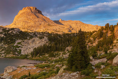
| Elephant Head above Island Lake. |
I drove 14 hours straight, leaving Seattle at 6:00 am and
arriving at Pinedale at 9:00 pm (1 hour time zone difference, for those
checking my math). The air was extremely
smoky and the sights poor from Hoback Junction to Pinedale. A nearby forest fire, which I knew about, appeared
to be much worse than I thought. My
hopes were dashed as I snuck in a dinner in town well after closing time. Not only was photography a question mark, so
was simply being able to breath.
I made the drive up to the Elkhart parking lot in the dark
to find the lot probably ½ full – also strange.
I slept in my vehicle and planned to start the decision making process
in the morning.
Morning arrived under cloudy skies and rain, with no smoke
to mention. It was on! The only question mark was when to leave the
TH. I waited until the worst part of the
squall appeared to be over, then set out on the trail.
I hiked 5.3 miles to Eklund Lake, pausing briefly at
Photographer’s Point to enjoy the traditional view. From there, I took a right and headed for a
new adventure! I traversed past too many
lakes to mention, most of which were not named on my map. Soon I arrived at Mury Lake, then began the
long traverse to Pole Creek Lakes.
There were numerous stream crossing, some more difficult
than others and requiring bushwacking/boulder hopping upstream several hundred
feet to find a safe crossing. This was
also tiring with a full pack at 9,000 + feet elevation.
Finally I arrived at the first Pole Creek Lake, which meant
I only had one more lake to go. I began
my rapid ascent toward my final destination for the day – Cook Lakes. It was a trudge and my gas tank was nearing
E. After another sketchy stream
crossing, I began my final approach to the lakes and soon found myself at the
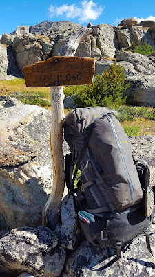
junction sign. From here, the lakes were
still another mile or so, and campsites yet another mile!
I arrived at Cook Lakes completely exhausted and found a
campsite looking like it needed a guest.
Lucky me. Distance for the day
10.4 miles.
I got camp set up and immediately started the stove up for
dinner. Soon it started to rain. I ate dinner under the protection of the
vestibule of my tent. Soon the rain
stopped and I cleaned up camp and retired for the evening. This is when the skies opened up and the drum
gods violently played their instruments, one wave after another. First it was large hail, covering the ground
white, then changing to hard rain. Soon
it would slowly calm down to showers and eventually, withdrawal to quietness
and solitude. Then the process would
repeat itself, over and over again. This
lasted almost the entire night. It was
fascinating and calming to me, in a strange way. Because I would experience storms like this
most every day of my trip, though not to this severity.
I awoke to cloudy skies and the threat of more showers. They did not let me down. At least they were short lived. I tried to light my stove for some breakfast,
only to learn my lighter was done. No
spark. It appeared to empty. I forgot to pack backup. Cold food would have to do.
I hiked back to the trail junction, swung right, and began
my ascent toward Lester Pass. I soon
reached Tommy Lake, which was absolutely stunning! Think Island Lake, but surrounded by meadows
rather than granite. My first thought
was how inappropriately named this beautiful lake was. I mean, who looks at a map and says, “I want
to go to Tommy Lake!”
 |
| Phone pic of Lester Pass. |
Lester Pass wasn’t much further, and offered the grand views
I had read and heard about. I stopped
for lunch and spent some time drying some of my gear out as well. Such a beautiful day.
The descent down to Little Seneca Lake was steeper, but
extremely scenic. My plan was to make
camp at Island Lake my second night, but fatigue was setting in. My legs were still struggling from the long
first day and I had come to the realization that a half day and rest was in
order. I found a camp in meadow near a
small, scenic lake above Little Seneca Lake and called it a day. The rest was nice. Distance ~5.8 miles.
That evening I finally got my first chance at some
photography after two days on the trail.
It was rewarding and motivating.
 |
| Reflection in alpine tarn. |
The next morning I awoke early and headed out for Island
Lake. I tried to time my arrival for around
9:00 am, when I figured campsites would be opening up (this is an extremely
popular lake – the destination of most people).
All worked well, though scouting the campsite took much longer. I overshot the area I wanted to camp and had
to come back searching for it. Distance ~3 miles with wandering.
I met Bill and Rachel from Minnesota, who were actually
instrumental in me getting a prime campsite next to them. They were fun people who I would get to know
better in the coming days.
I relaxed for the remainder of the afternoon in anticipation
of evening photography, which never happened.
While the day was beautiful, the typical afternoon/evening Rocky
Mountain storm moved in. While it struck
and eventually departed, clouds to the west remained and I never got any light
on the nearby peaks for sunset. So far,
the story of my trip.
 |
| Phone pic of Upper Titcomb Basin. |
The next morning I awoke early and headed out to revisit Titcomb Basin. There were few on the trail and it was an enjoyable hike. On a previous visit I hiked all the way up to Dinwoody Pass for views and photos of Gannett Peak. But today I simply visited the upper lakes, saving my energy for a visit of Indian Basin on my return.
The next morning I awoke early and headed out to revisit Titcomb Basin. There were few on the trail and it was an enjoyable hike. On a previous visit I hiked all the way up to Dinwoody Pass for views and photos of Gannett Peak. But today I simply visited the upper lakes, saving my energy for a visit of Indian Basin on my return.
While enjoying the environs of Titcomb Basin at very
leisurely pace, I met Jeff and Claire from Bozeman, MT. I recognized them from their dog as neighbors
from my second night camped above Little Seneca Lake. They were fascinating people and we must have
visited for over half an hour! All talk
was about our travels and recommendations for future travels. Fun!
I continued my retreat down the trail and soon came to the
Indian Pass trail junction, where I turned left and pursued my next
adventure. I had been to Indian Basin
previously, on my very first trip to the Winds in fact. We climbed Fremont Peak from Mistake Lake,
then descended into Indian Basin. It was
earlier in the year and the upper basin was mostly snow covered. I was excited to relive the memory and see
the basin in drier conditions. I wasn’t
disappointed. It was beautiful and I had
it all to myself. As the skies began to
change from blue to gray, I began my descent back to camp, arriving just as the
thunder gods began to bang their drums.
Distance for the day ~17.8 miles.
 |
| Phone pic of Indian Basin and Fremont Peak & Jackson Peak. |
Story time. During my
stay at Island Lake I witnessed blatant disregard for the rules. There was a burn ban in effect and the area
was signed no camping within 200’ of a lake (these signs were common at all
lakes I visited). Despite this several
groups decided the rules didn’t apply to them and set camp within 25’ of the
lake. There were also numerous bonfires
in the area that evening. As I sat at my
camp close to dinner time my first night, I watched 3 men pass my area and
descend down to the lake below me looking for a sight on the peninsula
below. The peninsula wasn’t even 200’ at
its widest point. The area was empty
prior to their arrival. I hoped common
sense would set in, but it did not. Up went
their tent. To make matters worse, they
were loud well into the night.
Fast forward. Upon
returning from Indian Basin, I found this group at camp and overheard them say,
“We have to move the tent”. It became
evident to me that somebody must have talked to them. They moved their tent 25’ behind a bush. They then proceeded to erect a tarp shelter
where their tent used to be. Total face
palm on my behalf. Did they seriously
think a ranger would allow this?
Soon rangers showed up (again) and informed them that they
could not camp at their new location.
The response I clearly heard was, “Well then, where are we supposed to
camp?” There were many sites available,
including just above me. These guys weren’t
the sharpest tools in the shed and classic comedy! The rangers ended up holding their hand and
leading them to an acceptable campsite, which they had walked by (if not thru) on
their way down to the illegal site.
 |
| Storm clouds part to reveal Fremont Peak over Island Lake. |
Why did I tell that story?
Because on the morning of me departure, I grudgingly ran into them on my
way out at a key point on the trail, messing up my navigation. Immediately after leaving my camp above
Little Seneca Lake en route to Island Lake earlier in my trip, I made note of
the switchbacks up an exposed hillside to Island Lake. I was watching for them on my way back down
as a landmark. It was at this location
that I ran into Dumb and Dumber and Even Dumber (sorry, but this was the joking reference being made of them).
But while conversing with them I lost sight of where I was
and continued on in search of the switchbacks.
Soon I came to a small lake and asked some people if I was on the trail
to Seneca Lake. Their response was
yes. I then came upon a very big lake
that took time to circumnavigate.
Strange that these lakes weren’t on my map (at least where I was
looking). Soon I was losing confidence
in the trail. It was descending, which
was the only trail in the area that should be, and by position of the sun it
was going in the right direction. Soon I
descended into forest unexpectedly and stopped once again to check the
map. Nothing looked familiar (keep in
mind I did not hike in this way, but had on previous visits). Soon I ran into a hiker coming in who asked
how I was doing. I answered, “Lost, I
think. Everything appears right, but I
am not recognizing anything along this trail”.
He asked where I was headed and I told him Elkhart TH. He replied that I was on the right trail
then. I pulled out my map and showed him
where I thought I was and he chuckled and said, “You aren’t where you think you
are. You know that big lake you passed a
little while ago? THAT was Seneca
Lake. You’re only about 6.5 miles from
the trailhead!” I could have hugged
him. One by one, all the prior details
started making sense.
 |
| Sunset at Island Lake. |
I arrived at the TH at 2:00 pm, ready for good food and the
drive home. Distance out 11.7 miles. What an amazing trip!
The last evening at Island Lake was amazing, and offered the best light of the entire trip. The skies opened with rain and hail only an hour before sunset. As sunset grew very near, the skies were gray and concealed the nearby peaks. All of a sudden the clouds began to lift with only minutes of light left. It was pretty magical.
You may view more images from this fantastic area in my Wind River Gallery.
You can also read about some of my previous trips to the Wind River Range at the following links:
Island Lake
Island Lake
As always, thanks for looking!


