Tuesday, October 25, 2011

Photographing the Enchantment Lakes

Prusik above frozen Gnome Tarn.
The Enchantment Lakes are one of the most beautiful destinations our state of Washington has to offer.  The high alpine lakes are set in granite basins surrounded by larches that turn brilliant gold in fall, and towering peaks above. They attract photographers, hikers and climbers from around the country.

You must have a permit to visit this fantastic place, which encourages one to plan in advance.  Of course, if you're feeling lucky, you can roll the dice the morning of by playing their lottery system.  Don't get caught without a permit; the rangers patrol the area and strictly enforce the permit policy.

Once the legal obstacles are handled, one must face the physical challenge of the approach, and decide which approach is best for them.

The Snow Lake approach gains 5,700' in ~9.5 miles.  Aasgard Pass, a favorite among many, has 1,000' less elevation gain and shorter distance, but uses a climber's path to ascend over a nearly 8,000' pass before descending to the lakes.  Neither approach can be classified as easy.

The Enchantment Lakes are best visited from late July through mid-October.  Late July-early August will often find the area mostly snow-covered, though peaks are very accessible.  Late August and September are the best hiking months; the area is mostly melted out and the weather generally continues to be nice.  This is a great time to explore and scramble in the upper basin.  October offers the turning of the larches, as well as the seasons.  It's common  to have a dusting of snow on the ground, making off-trail travel in the upper basin tricky.  Though photographic throughout the summer, October offers a photographer's paradise when the larches can be timed right.  Unfortunately, the weather can be unpredictable and present challenges.  One must be prepared for winter conditions, or to even cancel their trip altogether.

Larches above Sprite Lake.
 My first October visit to the Enchantment Lakes several years ago hit the larches at their absolute peak, and had fantastic weather from beginning to end.  I thought this was the norm.  My second visit found poor conditions with snow and heavy clouds.  I had to cancel my third visit entirely due to a prior system that dumped heavy snow in the area, and was forecast to last the duration of my visit.  I've learned to never take the Enchantments Lakes for granted again!

This year we once again had a system move in ahead of our visit, bringing temperatures in the 20's, and snow.  Nine inches of fresh snow were reported at Lake Vivian the day of our entry.  As such, we elected to to approach via Snow Lakes.  This would offer us a seemingly easier approach under the conditions, as well as an easier bail route should we need to beat a hasty retreat.

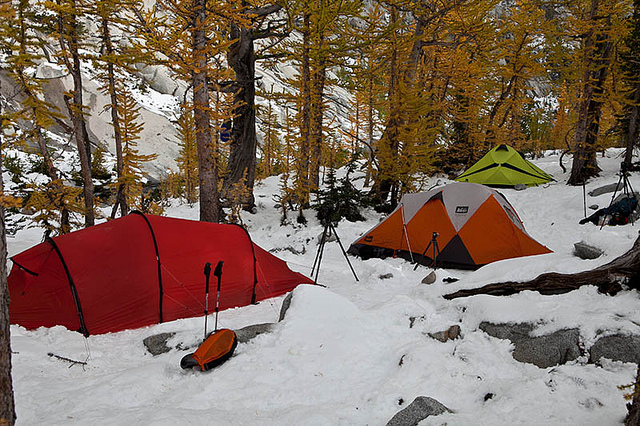
Camp near Sprite Lake.
We hiked in under sunny skies, knowing the forecast was for a short window of nice weather before a new system was to threaten our final day.

We arrived at Lake Vivian to find the few backpackers there had been tent-bound the previous day during a blizzard.  Reports were that nobody was camped higher.

We continued on to Sprite Lake, arriving after 9 hours of hiking and 5,700' above our starting point.  The snow awaited us as promised.
Prusik Peak Reflection near Leprechaun Lake.

October Photography

Photography options abound throughout the Enchantment Lakes.  But if looking for larches in October, the best option is the lower lakes; Lake Vivian, Leprechaun Lake, Sprite Lake, Perfection Lake, Inspiration Lake and Gnome Tarn provide excellent showings of larch.  Larch can be found higher, but their numbers are greatly reduced.  A central camp to easily access all these areas is recommended.

My Recommendations:

Prusik Peak above frozen Gnome Tarn.

Lake Vivian:  I have not photographed Lake Vivian, though having passed by it many times, I believe it to be very photogenic.  It offers a lake set in granite amidst larches, and a unique perspective of Prusik Peak above.  I'm not sure Prusik is very photogenic from this side, however.  I would probably tend to focus on the lake itself.  I hope to spend time photographing near its outlet stream, as well as up high from an obvious overlook along the trail.  I've always found myself passing through this area during the middle of the day, and camped too far away for a comfortable visit.

Leprechaun Lake:  I've always liked Leprechaun Lake.  It is lined with larches and offers excellent views of Prusik Peak and The Temple.  It's a large lake and subject to windy conditions.  I would suggest the chances of catching a reflection as slim to none.  However, don't despair!  Locate the trail that explores the peninsula of the lake.  At the very end are some tarns, one of which catches a beautiful reflection of the peaks above in late afternoon/evening, which is when the best light arrives.

There are many other excellent compositions to be had around this lake.  Be sure and check out the south shore.  A fun exploration to get there can begin from Sprite Lake.  More on that later.  There are also some beautiful tarns between Leprechaun Lake and the climb to Sprite Lake, and an interesting stream.
Upper Basin from Gnome Tarn.

 Sprite Lake:  Sprite Lake is a small gem of a lake encircled by larches, just shy of Perfection Lake.  It's quite pretty and often photographed.  If offers a small waterfall at its inlet from Perfection Lake, sandwiched between larches. Its outlet stream lines up to perfectly frame Prusik Peak.  There is excellent photography to be had from each and every side of this heavenly lake, which can hold an early morning reflection.  From this location, don't miss first light on the buttress above Perfection Lake to the west - it can turn a brilliant red in the right conditions, and reflects nicely if the water cooperates.

Wandering east off-trail from the lake, several tarns can be found, and much exploration around them.  I've spent an entire day playing in this area, and using it as a shortcut to access the south shore of Leprechaun Lake below by traversing around a knoll.

Prusik Peak above frozen Gnome Tarn.
Sprite Lake is also the popular jumping off point to visit Crystal Lake.  There is no camping at Crystal Lake, but it is a beautiful lake in a granite cirque with lots of interesting rock features and some larch - well worth visiting.

 Perfection Lake:  Perfection Lake is a very large lake with a prominent buttress to the west, and larches all around.  The basin at its head offers excellent groves of larch, and also serves as the junction with the Prusik Pass trail, which gives access to Gnome Tarn.  Campsites with incredible views can be found along this lake.  Goats are common residents here, as they are above.

Prusik Peak above larches and Perfection Lake.
There are many excellent vantages immediately around this lake for photographing, the best at or near the lake's head in my opinion.  For higher and much more encompassing views, follow the Prusik Pass trail up to Gnome Tarn, then gain the ridge above for unobstructed views back down to the lake, as well as Inspiration Lake and into the upper basin.

Other high views can be found by following the trail up to Inspiration Lake and locating the side-path near its outlet stream at the far end (before the steep climb).  For even higher views, continue with the steep climb up beside the waterfall.  At the top, take the side path east to the top of the prominent buttress seen below from  Perfection Lake.  The views are superb!

Photographer and upper basin of Enchantment Lakes.
Inspiration Lake:  Inspiration Lake is set in a deep cirque.  It's very scenic with larches lining its shoreline.  Isolation shots work well here.  Also, larches can be reflected in the lake.  Views from above the inlet waterfall are also very nice, allowing the inclusion of Prusik Pass and even Prusik Peak (though the later requires some work to successfully compose).

If you are staying at Inspiration Lake, make sure to follow the outlet stream to views of Perfection mentioned above.

Prusik Peak above Gnome Tarn.
Gnome Tarn:  Gnome Tarn offers the iconic image of Prusik Peak from the Enchantments.

For the easiest access to this lake, go to the junction at the head of Perfection Lake and take the Prusik Pass trail.

Many compositions can be had around this small tarn.  It holds a reflection of Prusik Peak well.  Add larches in season and the scene becomes...well, enchanting!

This scene is best photographed shortly after sunrise, once light has had a chance to light the rock of Prusik and the larches below.  If you arrive at or before sunrise, continue up to the ridge top to get above the larches to the south, and catch first light on the peaks of the upper basin - breathtaking!

Photographer in the Upper Enchantments.
The Enchantment Lakes are an incredible place to visit and photograph.  I would recommend budgeting at least five days for your visit, giving you an approach day, three full days to enjoy, and an exit day.  More days would be even better.

Having painted this area in such glorious light, I must also take time to stress some safety considerations.

Understand the physical challenge required to get into the Enchantments and make sure it is within your ability.  Both routes are physically demanding. 

Choose your gear carefully and be conservative.  Ounces add up quickly.  I recommend a wide-angle and medium range zoom lens, along with polarizers and GND filters for your camera gear.

Be prepared for the weather and elements.  The Enchantments can offer winter conditions at any time of year, and do.  October can be particularly cold.  During my visit, a group of photographers coming over Aasgard Pass in a blizzard learned this the hard way.  It ruined their trip.  Meanwhile, we found ourselves wearing all of our layers, all of the time!

I hope to have some of these images from my latest trip available on my web site soon.  In the meantime, feel free to check out images from previous Enchantment trips, or peruse other galleries of my web site.

If you have any questions, feel free to drop me a line.

As always, thanks for visiting!

Monday, October 10, 2011

Washington Trails Association's 2011 Northwest Exposure Contest

Prusik Peak and Larches.
If you haven't done so already, be sure and submit your favorite images for the WTA's 2011 Northwest Exposure Photo Contest!  This is a really fun contest with categories that fit almost every style of photography.

Images must be taken in Washington, and they must be from the hiking trail/backcountry (no backyard photos).

I will once again be serving as a panel judge for this contest, and am looking forward to reviewing another year's worth of fresh and exciting images.  I hope to see yours too!

The deadline for this year's contest has just been extended to October 17th.

For more information on this contest, please visit the WTA's web page.

Edit:  The WTA just created a profile page for us judges.  Visit it to learn more about us and what we are looking for in a photo.

Tuesday, October 4, 2011

Buck Creek Pass/Spider Gap Loop

Fortress Mountain above pink heather on Flower Dome.
 The Buck Creek Pass - Spider Gap loop is considered one of the premier backpacking trips in Washington, and with good reason.  Glaciers, high passes and lakes abound along this fantastic trek.  Throw in a side trip to Image Lake (a must!) and this classic is raised to an even higher bar.  Do this trip during flower season and it will add to your enjoyment and photography.  This is an outstanding flower hike in season!

I elected to do this trip in the reverse route than most people for several reasons.  The first was that I was starting my trek on Labor Day Weekend, and assumed Larch Knob, the obvious first night camp, would be crazy busy (I later learned it wasn't).  The second was that I preferred walking the Phelps Creek Road downhill back to my truck rather than uphill.

Glacier Peak from Buck Creek Pass.
So, leaving my truck at the Buck Creek TH, I began my ascent to Buck Creek Pass on the extremely dusty trail.  This was a 9-1/2 mile day with 3200' elevation gain.  There aren't many highlights along the lower section of trail; it's pretty much a matter of just grunting up to the high country and camp.

From the upper camps at Buck Creek Pass, the views of Glacier Peak are excellent.  In fact, the volcano can even be photographed from this location in the morning hours.  The downside to these camps is that they are much more dusty than the lower camps, and further away from water and the privy.

Fortress Mountain above lupine on Flower Dome.
Fortress Mountain receives the best evening light in the area, so a stroll to Flower Dome is a must in the evening for photographers.  Maps are incorrect that the trail stops short of the top.  Also, the trail doesn't mess around; it gains elevation at an aggressive clip.

From Flower Dome, views of Fortress Mountain are excellent, and the flowers are expansive!  I found the best vantage to be from the NW corner of the meadows.  However, I recommend hiking to the top, then scouting from above to find your photography location of choice.

The morning hours are all about the trail toward High Pass and Triad Lake.  At 6,800', Liberty Cap makes an excellent destination for views.  However, the best flower photography is found much lower down - less than 20 minutes from camp at Buck Creek Pass.

Glacier Peak above Image Lake.
Triad Lake is a highly recommended destination while in the area.  In fact, if I could recommend only one side trip from Buck Creek Pass, it would be Triad Lake.  For even better views, find a safe line of travel to High Pass.

From Buck Creek Pass, the trail descends to a crossing of Small Creek, then climbs up and over Middle Ridge.  Atop the ridge, an unmarked side trail ascends up to Sheep Camp.  This is reportedly a magnificent camp and based on what I saw, I would have to agree.  Next time!

From Middle Ridge, the trail descends to a crossing of Miners Creek  and then climbs towards Suattle Pass and the junction with Miners Cabin trail.

The Miners Cabin trail begins by traversing a steep hillside in trees to and cliffs.  Just pass the remains of the miners cabin is the junction with Miners Ridge trail, which switchbacks up to Ladyslipper Camp and then traverses beautiful open meadows of flowers in season, all the way to Image Lake.  Photographers can spend some serious time along this section of trail.

Soon one arrives at Image Lake and the rolling green meadows all around.  Bears are not uncommon here, especially on the higher slopes.

Evening light on Fortress Mountain.
For more flowers and excellent views of Fortress Mountain, hike back to the junction with the Canyon Lake trail.  Hike it a very short distance and find an unmarked boot path leaving it and heading uphill.  It soon becomes a very distinct trail, traversing flower meadows as it climbs to Point 6758.  This is an excellent evening destination for photography.

Image Lake stands a better chance of holding a reflection in the evening than in morning.  However, Glacier Peak receives only a sliver of light on it's upper slopes from this vantage.  In my opinion, compositions of the lake and Glacier Peak are better served in the morning.

Sunrise on Glacier Peak above Image Lake.
Many choices and vantage points around Image Lake are available to the photographer.  Indeed, one may wish to spend a couple of days in this area to compose from multiple locations.

A trail navigates around the shores of the lake, placing the upper slopes of Glacier Peak immediately above the trees to the south for an interesting composition.

Up higher, a horse bypass trail navigates high above the delicate areas around the lake and offers a much different perspective.  This vantage offers more of the mountain and forests of the Suattle drainage, as well as a more encompassing view of the lake and surrounding meadows.  A trail on the north side of the lake connects these two trails.

Glacier Peak above Image Lake.
I found this area to be best photographed at sunrise, and then again in mid-morning once the lake and meadows receive sunlight.  Light comes fast to this basin, so don't wait too long.

Once the sun has climbed high in the sky and the photography is done, sprawl out and relax in this beautiful setting!

From Image Lake, one must retrace the trail back to the junction and continue on toward Suattle Pass.  A junction just before Suattle Pass gives the hiker a choice of taking the highly scenic shortcut to Cloudy Pass.  If conditions allow, I recommend it.

Dumbell Mountain above Lower Lyman Lake.
The views from Cloudy Pass are impressive.  Arriving at the pass and seeing the view of Lyman Lakes for the first time is an eye-opener - much more so than seeing them from Spider Gap, in my opinion.  There are campsites at and around the pass.  From the pass, a trail ascends up Cloudy Peak, offering many scenic campsites along the way and opening up views to Glacier Peak and north to Buckner, Goode and...the list is too long!

Camp above Cloudy Pass below Cloudy Peak.
This area was also the buggiest of my entire trip.   After setting my camera up on my tripod, I counted 12 horse flies on it within moments during mid-afternoon.  They were nasty!  In the heat of the day, I had to cover up in clothes.  I tried to hide from the flies in the shade, but the mosquitoes were there waiting to swarm me - in the middle of the day.

After a couple of hours of this annoyance, a couple of strong, extended gusts of wind blew through the pass.  When they stopped, I realized the large horse flies were gone.  They never returned.  It was the strangest thing.

The picture to the left shows my camp, as viewed from a knoll above the pass.  It's deceptive.  My camp is actually about about 50' or so above the pass.  Still it gives you a good sense of the area.  You can also see the path climbing the far slope to higher camps and views on Cloudy Peak.

I spent the evening photographing Dumbell Mountain above Lower Lyman Lake from a knoll to the west of the pass.  I really enjoyed this vantage.
In the morning I ventured up to a shoulder on Cloudy Peak, where Glacier Peak could be viewed through the V gap of Cloudy Pass and over Middle Ridge.  Lyman Lakes Basin didn't receive the morning light I thought it might.  The minor ridge to the west of Cloudy Pass and below Fortress Mountain did though.

Fortress Mountain above Cloudy Pass (my camp is just to the left of
snow patch, bottom right corner).
 Cloudy Pass is a wonderful area to hang out and explore (less the bugs).  Water is available just 1/4 mile below the pass if a water source cannot be found up higher.  I had the pass all to myself the night of my stay - well, except for the deer that visited me throughout the night.

From the pass, the trail descends through open meadows, then forest, to Lower Lyman Lake.  Near the lake's outlet stream is a junction, with the trail to Upper Lyman Lakes crossing the outlet stream and ascending the slopes beyond.

Reflection near Upper Lyman Lakes.
 Soon the trail leaves the forest and climbs through open meadows.   Bonanza Peak emerges to dominate the skyline to the east, while tarns catch the reflection of the ridge to the west serving as a backdrop to Lyman Lakes.  There is a lot to see and explore in this area, and a visit to the first upper lakes is a must.

Again, I was surprised to not see a soul in this area during my visit.  In fact, I didn't run into a single hiker after leaving Cloudy Pass until ascending to the Spider Gap col.  I would guess a weekend would be much different.
Reflection near Upper Lyman Lakes.
Finally, the much anticipated upper lake is reached and it is as advertised with the Lyman Glacier spilling into the lake below the icy walls of Chiwawa Mountain and icebergs floating in the lake.  One can only reflect back to older generation pictures of this glacier when it was much greater in size.  But the sight is still impressive.

This upper basin is an area that doesn't receive much light outside of mid-day.  Clouds would definitely help with photography here.  I had none, so I played with isolating the glacier and lake.  Still, the light was harsh and I would have preferred some high clouds to help diffuse the light.

The basin is also quite large and demands much exploring.  Definitely find the moraine trail along the shore of the upper lake.  You can follow this as far as you wish toward the Lyman Glacier and snow bank at the south end of the lake.  Find a spot atop one of the many large boulders and find time to relax and reflect.
 
Yours truly at Upper Lyman Lake.
 The route over Spider Gap is very straightforward and easy to navigate in nice weather.  The descent of the Spider Glacier down to Larch Knob was equally easy.  I highly recommend spending a night at Larch Knob!  Again, this is an area set in the deep valley of Phelps Creek and only receives mid-day light.  Seven Finger Jack and Mt. Maude receive evening light, but lack visual interest from this perspective without the help of dramatic clouds, in my opinion.

From Larch Knob it's a steep descent down to Spider Meadows via many switchbacks, but the trail provides a birds eye view of the valley below, which are quite impressive.  Spider Meadows offer a pleasant stroll through flowers in season.  Beyond the meadows, the trail is uneventful back to the trailhead, with the possible exception of crossing Leroy Creek in early season.  Then a 3 mile road walk back to your vehicle greets you.

Camp at Larch Knob with the Spider Glacier in the background.
I was surprised not to see any bears on this trip.  Buck Creek Pass was crawling with hunters, but in years past I have seen them around Image Lake and Suattle Pass.  I also expected to see one or two around Lower Lyman Lake.  But it was not to be.

I found my 24-70mm lens to be my only lens used on this trip.  I carried my 17-40mm, but it never saw the light of day.  I left the bigger glass at home, as I typically due on such extended trips.  The weight isn't worth it.

I highly recommend this extended backpack!  I would budget 6-7 days to really enjoy all it has to offer.  I would not consider anything less than 4-5 days.
As always, thanks for visiting!