Thursday, May 26, 2011

Mount St. Helens - Norway Pass and Mount Margaret Backcountry Area

Mount St. Helens from Norway Pass.
Mount St. Helens offers excellent hiking with worthy destinations all around the mountain.  One of my favorite areas is the Mount Margaret Backcountry area near Windy Ridge.  The area provides classic views across Spirit Lake to St. Helens.

Bear Camp offers excellent camping, and is situated close enough to Mount Margaret to serve as a base camp for a hike to this magnificent summit.  Watch for elk herds in the area!

One of the highlights early in the hike is Norway Pass.  A great wildflower area, this pass affords excellent views down to Spirit Lake and Mount St. Helens.

The image above is not my favorite image from the area - not even in the top 5.  But it has been popular for publications.  It has appeared in a couple different wall calendars (one multiple times), and is currently the image for the month of May in Smith-Western's Mountains of Washington wall calendar.  It will also be appearing in the June issue of a national magazine publication.

I hope to have more Mount St. Helens news to share very soon - stay tuned!  In the meantime, you can view more images from this monument at in my Central/South Cascades gallery.

As always, thanks for visiting!

Monday, May 23, 2011

Photographing the Racetrack in Death Valley National Park

Sliding rock at southern end of The Racetrack
The Racetrack is probably the most intriguing feature in Death Valley National Park, involving sliding rocks on the barren playa.  You've surely seen the pictures.  They are very recognizable as the rocks leave a long trail behind.

Located between the Cottonwood Mountains to the east and the Nelson Range to the west, the Racetrack is exceptionally flat and level (only 1.5" height difference between its southern and northern end).  It's dry for almost the entire the year.  But when heavy rains do arrive, water rushes down these mountains onto the playa, forming a shallow lake.  It's short-lived as the hot desert sun quickly evaporates the water, leaving a surface of soft, slick mud.

Sailing stones on north end of playa.
The sliding rocks, or "sailing stones", slowly move across the slick surface of the playa with the aid of strong winter winds, leaving a track behind them.  This phenomenon has never been witnessed or filmed, likely because the remote playa is not approachable under such conditions.

These stones only move once every 2 to 3 years, and their tracks last 3 to 4 years.  Stones with rough bottoms tend to leave straight tracks, while smooth-bottomed stones wander.

Interesting, huh?  Most photographers think so!

There is a challenge to visiting this playa, however.  It is very remote, accessed via a very rough 28 mile road.  The Racetrack Road is best suited for high-clearance vehicles.  Flat tires are a common occurrence.  The road can be heavily washboarded, rattling suspensions, and must be driven slowly.  I would budget at least 3 hours for this drive.  Storms and flash floods can make the road undrivable.

Teakettle Junction.
The Racetrack Road is an interesting and scenic drive.  Flowers can line the early stretches of road in spring.  At about 9 miles in, the road passes through a Joshua tree forest with many photographic opportunities.  Legendary Teakettle Junction is reached 10 miles further.  Past Teakettle Junction was the roughest stretch of road during my visit - 9 miles of extremely washboarded road to the Racetrack.  These poor conditions continue to Homestead Dry Camp, in case that is your destination.

Excellent photography can be had in both morning and evening at the Racetrack.  Morning is considered the better light, but I achieved my best images while scouting the evening before.  The southern end of the playa tends to have the most rocks, while the north end sports The Grandstand, which makes a fun compositional backdrop if rocks are present.  There were no rocks near The Grandstand during my visit, to the shock of several photographers who had just visited the year prior.

Sliding rocks on the Racetrack.
Morning light happens fast here, so definitely spend time scouting the playa the day before for the best rocks and tracks.  You will also find that the rocks come in all shapes and sizes, and sometimes can be photographed in pairs.

Enjoy your visit and travel safely!

This is my last installment on photographing in Death Valley National Park.  I hope you've enjoyed my recommendations and tips, and that I have inspired you to visit this wonderful place yourself.  If you would like to see more images, please check out my Death Valley gallery.

Thanks for reading.  And as always, feel free to send me a note with any questions you may have that I have not answered here.

Thursday, May 12, 2011

National Geographic Geotourism Map

Recently I was preparing tear sheets for some upcoming mailings and I was reminded of this cover image for a National Geographic geotourism map. 

The geotourism map series promotes tourist spending in a way that puts their money back into the local economy and helps to sustain and support the community.  An example would be to eat at locally owned and operated eateries instead of chain food restaurants.

This image was taken at Spray Park in Mount Rainier National Park in early summer.  The white flowers are avalanche lilies, one of the first flowers to bloom after the winter snow melt.  I would typically target mid-July for such an image, but it will be much later this year due to the high volume of snow in our mountains.

This image also appears in my book Mount Rainier.

Friday, May 6, 2011

Photographing Fall Canyon in Death Valley National Park

Hiking Fall Canyon.
Fall Canyon is located just north of Titus Canyon (a highly recommended drive!).  It is one of the most spectacular canyons in Death Valley National Park.

The trail starts from the parking lot at the base of Titus Canyon, where the road is gated for one-way traffic coming the other way.  The trail leaves to the north and traverses to the wide fan of Fall Canyon, with excellent views down to the valley below along Scotty's Castle Road.

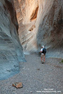
From its mouth, Fall Canyon is a deep gorge with amazing walls.  The canyon gets deeper and the walls more and more impressive the further into the mountain you go.

At several places within the first 3 miles, the wash squeezes through impressive narrows that force one to crane their necks to the walls above.  The canyon walls climb vertically for hundreds of feet, and are topped by even higher walls.  Vertical compositions work well at these spots.  I also recommend a warming filter.

Hiking Fall Canyon in Death Valley
National Park.
 The walls are colorful, and include shades of blue, tan, dark brown and red. As the sun's angle changes throughout the day, so do the vibrant shades of the rock.  The reds grow deeper in the evening as the sun sets, turning flaming red for the final show. 

At about 2.5 miles, the canyon is blocked by an 18 foot fall that poses a considerable challenge to the best of rock climbers.  This is a very scenic spot for photography of the steep walls and seemingly insurmountable fall.  Seemingly?  Yes, there is an easy way around.  Simply backtrack about 300 feet to find a path climbing upward to the south.  It climbs steeply up a chimney to the south, then mellows out as it climbs a ledge over a high spot and descends down to above the fall.

The next third of a mile contains the tightest narrows of the canyon, and are very photogenic.  The deep, dark, polished rock through this windy passage is extremely scenic, and the best part of hike!

I recommend focusing on vertical compositions to capture the feel of the towering walls above.  I believe that adding a subject matter for purpose of scale also works well.  Abstract patterns in the rock can also be played with.  Normal and wide-range lenses work well here.

At a quarter mile above the first fall, the canyon opens up until mid-canyon is reached in about 3.5 miles.  I did not venture up to mid-canyon, but have friends that thoroughly enjoyed it as a backpack (and continued further).  The lower canyon makes for an excellent half day excursion with endless photography opportunities.  Which ever way you choose to enjoy this area, do just that - enjoy!

If you wish to view more images from this area, feel free to visit my Death Valley gallery.