Sunday, June 18, 2023

Bighorn Canyon National Recreation Area

Image of Bighorn Canyon
Bighorn Canyon NRA
Bighorn Canyon National Recreation Area is comprised of two districts and straddles the border of Wyoming and Montana.  The north district is located in Montana and used mostly for boating recreation while the south district is accessed in Wyoming and offers primarily land-based recreation, including the incredible Devil Canyon Overlook.

At the bottom of the canyon lies the Bighorn River, which snakes through its rugged, steep walls in its journey northeast.

Image of Bighorn Canyon
Bighorn Canyon NRA
The remoteness of this area lends itself to a modest number of visitors - just over 200,000 per year.  The main attractions are sightseeing, boating and hiking.

The centerpiece of the south district is Devil Canyon Overlook, pictured here.  It is comprised of a parking lot on a bluff overlooking the canyon, with walkways along the fence near the edge.  The views are incredible.

My favorite time to visit this overlook is in the morning hours, staying until mid-morning to get full light in the canyon.

Image of Bighorn Canyon
Bighorn Canyon NRA
But afternoon and evening are also very nice times to visit, especially with incoming storms approaching.  I was fortunate enough to experience such as the black ominous clouds filled the sky from the south and east while filtered light from the west highlighted the canyon walls.  The sound of rolling thunder added to the splendor.

The storms were short-lived during my visit, soon passing and relinquishing the sky back to sunshine and evening sunsets.

While I photographed during sunrise, mid-afternoon storms and sunset, I only shared this spectacular view with a handful of people.  I did not see another photographer during my entire visit.  It could be a lonely place.

Image of Bighorn Canyon
Bighorn Canyon NRA
Mornings in particular were void of visitors.  I camped nearby at Trail Creek Campground (shared with only one other party) and arrived approximately half an hour before sunrise, only to find the parking lot bare.  Visitors didn't typically begin arriving until well after sunrise.

Evenings tended to receive more interest, though still in limited numbers.

In between canyon photography times there are other things to do, such as hiking, boat tours at Horseshoe Bend (not yet running during my visit due to low water level) and wildlife viewing.

Wild mustang in Pryor Mountain Wild Horse Range
Wildlife include bighorn sheep, deer, elk, black bear and wild horses.  Yes, you read that correctly - wild horses!

The Pryor Mountain Horse Range is the only federally protected wild horse range in the U.S., and shares land within Bighorn Canyon NRA.  Approximately 90-120 wild mustangs roam the area and can be viewed from the road within the park.

Technically, these mustangs are considered feral, having escaped captivity and thrived in the wild.  They have unique physical traits which include a triangular face and short pointed ears.  They are also very muscular.  DNA tests have linked them to horses brought to the area by the Spaniards.  In fact, they most closely resemble the Spanish Colonial horse, a very rare breed today.


Image of Bighorn Canyon
Bighorn Canyon NRA
Photography Gear and Advise:  My most used lens by far for landscapes was my wide-angle, 17-40mm.  I found this lens to best include as much of the canyon as possible and convey its depth and size.  This lens was also excellent for including afternoon storm clouds above the canyon.

My 24-70mm also saw some action of course.  Primarily isolating the canyon and its reaches downstream.

Of course, my 200mm lens coupled with my 2.0 teleconverter saw plenty of wildlife action.  The main subjects were bighorn sheep and the wild mustangs.

Image of Bighorn Canyon
Bighorn Canyon NRA
The best opportunities for photographing the canyon are right from the overlook proper, especially if trying to capture the river bend.  There are views to be had on all three sides, though the best is looking to the southwest.

For a different view, one can backtrack to the parking lot entrance and find some game trails heading to the west to some excellent perches.  Be careful as footing can be loose.  This offers some unique views and compositions, though the bend of the river will be cut off.  Still, they are interesting.

Finally, I can't encourage you enough to drive the Bighorn Scenic Byway (Highway 14) over the Bighorn Mountains to Sheridan and I-90.  The scenery is spectacular and wildlife plentiful.  Several miles of this drive are between 8-9,000' with views as far as the eye can see.  Spectacular in all directions!

You can see these and more images from this area in my Bighorn Canyon Gallery.

I hope this information helps in the planning of future trip!  As always, thanks for looking!


Saturday, June 10, 2023

Quilcene River, Buckhorn Wilderness, Olympics


Image of Quilcene River
Quilcene River and moss.
The Quilcene River has always been one of my favorites in the Olympics, located on the eastern side near the town of Quilcene.  Despite being on the leeward side of the Olympic Mountains, the green moss lining the stream is more reminiscent of the Hoh River drainage on the western side!

The Quilcene is most commonly hiked by those ascending to the high country of Marmot Pass or even Buckhorn Mountain at 6,983' - two outstanding destinations!  As such, it is easy to put the blinders on in the lower forest as one focuses on the task at hand.

However, in early season the lower forest along this beautiful stream IS my focus!  Super-green moss and waterfalls a plenty are enough to captivate my interests.  Early season can also make it a vey lonely trail as deep snow blankets the high country.

This image has stood the test of time and has recently been licensed for Worldwide usage in a magazine, as well as supporting digital use.

You can see this image and more from the area in my Olympic Gallery.

As always, thanks for looking!  Hope to see you on the trail!
Sunday, February 5, 2023

High Divid, Olympic National Park


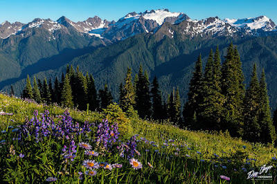
Image of Mount Olympus Above Flowers
Mount Olympus from High Divide, Olympic National Park
High Divide is one of the most popular hikes/backpacks in Olympic National Park.  Whether day hiking the loop trip (easily done in a day for experienced hikers) or backpacking with camps at Seven Lakes Basin or Heart Lake.

A trip into this area offers so much beauty for the adventurer willing to put the distance in.  Summer offers meadows of flowers, while fall offers vibrant fall foliage of reds, oranges and yellows.  You really can't go wrong on when you visit. Oh, and the wildlife!  Your chances of seeing bears, deer, marmots and more are quite high.

Both camping areas mentioned above a beautiful and prime destinations.  If planning your trip for photography on the ridge, I would recommend giving the nod to Heart Lake or a campsite on the ridge (dry).  Seven Lakes Basin still works, it's just that your hike back to camp in the dark (assuming you are staying for sunset) will be a bit longer.  Still, Seven Lakes Basin is beautiful...

For the image above, Seven Lakes Basin was my place of stay as a last-minute permit became available.  The opportunity to visit this high ridge to both view and photograph Mount Olympus was exciting! And I was not disappointed.

I'm happy to share that this image was recently licensed for worldwide use for print cards.

To see more images from this fantastic area, feel free to visit my Olympic Gallery.

Hope to see you on the trail in 2023!

Wednesday, January 25, 2023

King Tides at Cape Disappointment in Washington


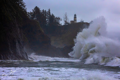
Image of King Tides, Cape Disappointment
King Tides at Cape Disappointment.

"King Tides" is a non-scientific term used to describe higher than average high tides.  In Washington, these typically happen during the winter months of November, December and January for a three-day period.  They are the result of the gravitational forces of the sun and moon basically playing "Tug-of-war".  They typically occur during a full moon and can be further escalated by storms.

In my state of Washington, these typically occur in the winter months of November, December and January, and for a period of three days each.
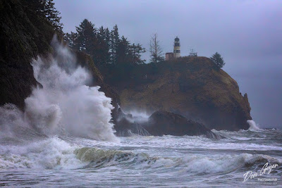

Image of King Tides, Cape Disappointment
King Tides at Cape Disappointment.
The year I visited Waikiki Beach at Cape Disappointment for the first time and was not disappointed!

This might be the most iconic place to photograph the tides in Washington despite it's remoteness, near the small town of Ilwaco.  The park offers camping, hiking and access to wild beaches not typical of Washington's southern coast.  It's about a 3 hour drive from the Seattle area, and is actually much closer Portland, OR!

Watching and photographing the tides is an incredible experience.  Get there early for the full experience.  Seeing the surf a few hours before high tide and witnessing it build to a crescendo is the exhilarating experience that one brings home with them and tells stories about!

Image of King Tides, Cape Disappointment
King Tides at Cape Disappointment.
Photographer Tips:  While the tides are always exhilarating, the best images are captured when the water is backlit to bring out the greens.  This doesn't happen under heavy clouds.  Plan your trip when you suspect you will see some partial sun or at least diffused light.

Telephoto lenses work the best here.  I enjoyed my 70-200mm lens the most.  A stronger lens could capture the details of the waves up close.

Don't forget to give your camera a break and just enjoy the beauty and raw energy of the surf.  Especially near the high tide when the water is churning every which way.  It was during this incredible time that I heard an interesting "chirp" and noticed it wasn't a bird, but rather a sea otter swimming back and forth on its back "people watching"!  How was he staying afloat?!!

For more images of the Washington coast, feel free to visit my Washington Coast Gallery.

As always, thanks for looking.  Hope to see you at the coast?

Sunday, January 15, 2023

Bryce Canyon National Park in Winter


Image of Bryce Canyon National Park in Winter
Bryce Canyon National Park in winter.

Having visited this park in spring and summer, I had always wanted to witness it under a blanket of snow in winter.  One early February I got my chance.  Closely watching the weather forecast, I saw and incoming storm expected for the area.

My plan was to sleep in my vehicle.  However, at the last minute I discovered I would be bringing guests – my kids, early and middle elementary school ages!  Our only choice was to tent it – their first winter snow camping experience!  We shared the entire Bryce campground with a single motor home.

Temperatures during the day with in the 20’s and low 30’s.  Nighttime dipped into the low teens.

Night came early of course, so we found ourselves bundled in our sleeping bags playing cards with the illumination from our headlamps.  The kids had a blast!  I will always cherish the special memories from this trip.

The next morning, I awoke to a wall of spin drift (blown snow) completely block the outside of our tent door.  It was 13 degrees outside as I hiked to the rim of the canyon for sunrise.  It was beautiful!

This image appears for the month of January in my 2023Western Landscapes wall calendar.

You may view more images from this area in my SouthwestGallery.

I hope you enjoy!