Tuesday, September 22, 2015

Mount Hood from the Timberline Trail

Mount Hood from McNeil Point.
Several years ago I hiked a section of the northern Timberline Trail with a friend.  They say the prettiest and quietest meadows on Mount Hood are on its north flanks - opposite the crowds at Timberline Lodge.  I would have to agree.

The meadows were fantastic along the Timberline Trail and above.  Surprisingly to me, the trail was devoid of people.  We encountered very few people on this trip, and the few that we did were day hikers.

We spent our first evening climbing up McNeil Point.  The lighting was fantastic at the end as we watched it fade on the mountain.  Unfortunately, the sky didn't offer many clouds for drama, so it was mostly about the experience.

Mount Hood reflected in a tarn along the Timberline Trail.
The next morning we awoke early and returned to Dollar Lake, which we had scouted the day prior.  We then marched upward toward the top of Barrett Spur to get some more photography in before the late became too harsh.

The off-trail explorations were numerous and quite fun!  The scenery, of course, was incredible.

I've had three images from this trip appear in various publications - all shown here.

Mount Hood from Barrett Spur.
The most recent image is the top one from McNeil Point.  It is currently being featured as a full page image in a book being distributed world-wide.

This is an area I've always vowed I would like to return, only later in the year when I little more snow is present on the upper slopes of the mountain.  Perhaps this could be that year?

You can view these images of Mount Hood and more in my Mount Hood Gallery.

I highly encourage you to check this area out for yourself.  It's a bit of a drive from the Seattle area, but the scenery and solitude is well worth it.

As always, thanks for looking!


Monday, August 3, 2015

A Scene Forever Changed

The image to the left of St. Mary's Lake in Glacier National Park, taken shortly before sunrise from the Wild Goose Island overlook, was taken in 2010 (has it really been that long?).  I remember waking up 3 hours before sunrise at my camp at Avalanche Creek and driving the Going-to-the-Sun road over Logan Pass to beat the photographers camping near St. Mary Lake.  While I always won this race, I never needed to.  There was always plenty of room for everyone, and each morning was fun filled with joking and wild stories.  Photographers can be such a great group of people.

Will it be worth the drive and dedication in the future?  Will the landscape be forever changed?  This we will have to wait and see.  This entire area is currently closed due to a devastating wild fire, which will likely reshape this landscape into something much different when all is said and done.

The Reynolds Creek Fire was first reported on July 21st, 2015.  As of this writing, it has already burned over 3,558 acres in the park.  Over 515 personnel, 12 engines, and 7 helicopters are currently fighting this blaze, which is listed as 65% contained.  It is believed to be human caused, though InciWeb still officially lists the cause as "under investigation".

The Going-to-the-Sun Road is closed on the east side from the St. Mary Campground to Logan Pass.  And with the fire burning in close proximity to the road, this isn't expected to change anytime soon.  Already charred areas are reigniting due to low humidity and high winds.  Fire and smoke are expected to be visible up the Rose Creek drainage until the first snow of winter arrives.

I'm sure photographers, hikers, backpackers and outdoors enthusiasts in general are crossing their fingers and hoping for the best, especially those who have not yet had a chance to visit this beautiful and iconic place of the park.

I've spent a LOT of time in Glacier National Park hiking, backpacking, climbing and photographing.  I list the park as one of my favorites, and cherish the memories I've been fortunate to create there over the years. 

It's been a crazy year all over the west with wild fires.  There are several large ones currently in my home state of Washington.  California and Oregon are also experiencing tinderbox conditions.  Unfortunately the forecast is for conditions to worsen before they get better.

While wild fires are an important part of our ecosystem and many of us have learned to accept them as "change", it is always tough to see the aftermath - especially when it takes place in such a popular and scenic area of a national park.

My thoughts are with those battling this blaze, for their safety and well-being.  Stay safe.

I would like to credit InciWeb for the information and statistics reported above.  I recommend them as an excellent source to follow updates on wildfires.

If you haven't been so fortunate as to visit this beautiful park, or simply wish to take a stroll down memory lane, please feel free to visit my Glacier National Park Gallery.

Hope to see you on the trail in much safer conditions.


Sunday, July 19, 2015

Flowers at Mount St. Helens

For many people, the subject of Mount St. Helens brings only imagery of devastation and destruction.  That is understandable, of course. 

For me, St. Helens brings imagery of that fateful day in 1980 certainly, but also many more.  I have triumphantly stared down into the crater from the summit rim, hiked and photographed my kids on its trails for publications, enjoyed its flower show in early July, and sadly, lost my dad in a tragic fall on a late October day.  The emotions the mountain has brought me pretty much run the gamut.

Mount St. Helens has a lot to offer, which might surprise a lot of people.  One of them is its flower show.  Yes, you read that correctly.

While most of the crowds flock to its neighbor to the north for the supreme flower shows, St. Helens proudly shows off her own display for those willing to come calling.  It's a further drive for most in the Puget Sound area, but well worth it.

This has been a very interesting year, with summer starting approximately Decemberish.  I kid, of course, but there is an element of truth to it.  We didn't have a winter.  The ski areas only opened long enough to seemingly meet the minimum requirement of days that they would not have to offer refunds (sad and unethical, in my opinion), and we never really had any measurable snow at the low to mid elevations in our state.

We had above normal temperartures most of the spring and early summer, shattering old records in some instances.  This cause rapid snow melt (what snow there was), and flowers emerged almost a month early on average.  I'm sure this caused great frustration for any out-of-towners scheduling vacation to be out here in late July or early August!

So the flower came early, as did access to higher level hiking trails.  Hikes that shouldn't be accessible until late July or early August were being done in early June!  It was crazy.

While the flowers came early, the displays I witnessed personally at Mount St. Helens did not measure up to normal years.  I spent time in both the Windy Ridge area and Johnston Ridge, and feel this statement is accurate for both areas.

The Windy Ridge side was actually quite disappointing.  I spent time around Windy Ridge proper, hiked the Mt. Margaret backcountry to Norway Pass and to the top of Mt. Margaret, and spent an evening at the Smith Creek Viewpoint.  Flowers were scarce.

Johnston Ridge offered a far better showing, whether descending the Boundary trail from near the Johnston Ridge Visitor Center, or hiking up the trail toward Harry's Ridge or Coldwater Peak (of which I did both).  While there were some excellent displays along both areas, I've seen better showings in previous years.  Variety was mostly missing.

What I was treated to during my visit to Johnston Ridge were some amazing sunrises and sunsets!  Unfortunately, the highlight of these shows were not above St. Helens, but rather to the north.  Still, they were amazing.

Back to the flowers (sorry, morning and evening sky shows distract me!).  What happened once the flowers emerged?  A continued warm and dry spell, that has continued to the day I am writing this.  This resulted in the flower display being very short lived due to lack of precipitation.  If you blinked, you missed them.

How did the flower show compare to the famous offerings at Rainier?  Well, I hoped to offer just that, but unfortunately, I cannot.  I fractured a toe at this most untimely period and was forced to take an unwanted break from hiking and photography.  However I have heard by many that the flower duration was very short there as well.  Due to our hot temperatures and lack of rain, I'm pretty confident this held true for most if not all of our state.

I hope you are all out enjoying our beloved hiking trails and enjoying this rare opportunity of great hiking weather most each and every day.  The latest forecast models for the Pacific Northwest show this pattern continuing through...wait for it....October 2016!

Hope to see you on the trail (eventually)!


Monday, July 13, 2015

Washington Trails Magazine

I would like to thank Eli Boschetto and the gang at Washington Trails Association for selecting my image of Glacier Peak and Image Lake for their July/August cover.

This image was taken during an amazing 5-day backpacking trip, starting and ending at Trinity, at the end of the Chiwawa River Road.  I connected Buck Creek Pass, Image Lake, Cloudy Pass, Lyman Lakes, Spider Gap and Spider Meadows on this adventure.

At the time I did this trip, access to the Glacier Peak Wilderness had restricted access from the west side due to serious flood damage along its primary access routes.  This included the Suattle River Road and the White Chuck River trail.  For hikers, this meant heading east of the crest for the easiest access to this area.

That has now changed.  After being closed for more than a decade due to limited budget, legal battles with over-the-top environmental groups, and complicated redesign plans, the Suattle River Road was opened to vehicle traffic on October 25th, 2014.  It gives access once again to 120 miles of hiking trails, including the Pacific Crest Trail (PCT).

The Suattle River Road is also a key entry/exit point for one of the most famous high country traverses in our state, the Ptarmigan traverse.  I have done this traverse several times, and am excited about doing it again in the coming years (fingers crossed!).  This traverse begins at Cascade Pass in North Cascades National Park and ends at Downey Creek along the Suattle River Road (or vice versa).

I hope you get out to visit some of the amazing scenery this area has to offer.  Hope to see you on the trail!

Wednesday, July 1, 2015

Island Lake, Wind River Range

Early light on an unnamed bluff near Island Lake in the Wind River Range, Wyoming, USA.
Island Lake, Wind River Range, Wyoming.
The Wind River Range in Wyoming is one of my favorite hiking, climbing and photography playgrounds.  The area has become considerably more popular in recent years, namely the Cirque of the Towers and Titcomb Basin areas (other areas can still be void of people!).

This image of an unnamed bluff at Island Lake was taken shortly after sunrise, very near camp.  I had backpacked in with big climbing aspirations, only to turn my ankle in the first couple miles of the hike.  With trekking poles I was able to continue the hike at a snail's pace to our destination, but that was it.  I spent the next several days resting my ankle and soaking it in the cold water in hopes of prepping it for the hike out.  It seemed to work!

This image recently appeared in a national newspaper in the U.K., supporting an editorial article about dumb hikers who injure themselves in the backcountry.  I'm kidding of course!  At least about the article content anyway.

If you are interested in the Wind River area, I invite you to view my Wind River Gallery for many more images.  I hope they motivate you to consider paying the area a visit.

As always, thanks for visiting!

Friday, June 19, 2015

Photographing Windy Ridge at Mt. St. Helens

I spent last weekend down at Mt. St. Helens - Windy Ridge area to be exact.  I chose this area for the likelihood of clouds and flowers based on the forecast and some recent trip reports.
 
I had clouds around the summit of St. Helens most of the day, and thunder clouds engulfing the Cascade crest.  I was excited for what evening would bring, but alas, the clouds faded and all but disappeared by sunset.  I hoped for their return as forecast in the morning, but it did not happen.

While the flowers were out along my climb of Mount Margaret and around Windy Ridge, they just are not the strong showing I am accustomed to in the area.  They are quite sparse, actually.  It will be interesting to see how the flower show develops around Mt. Rainier in a couple of weeks (the park predicts peak bloom to occur in early July this year).  Will they be fabulous fields of splendor, or skeletons of their normal selves?

I spent some time doing star photography around midnight in the Windy Ridge vicinity as well.  I'm pretty new to star photography, and there were a lot of rookie mistakes made!  But I also found some things that worked and am anxious to get out and try again.

The orange and yellow you see on the horizon is not the sun, but rather light pollution from the Portland and Vancouver area.

I hope you are getting out and enjoying the early hiking season as well.  Hope to see you on the trail!


Tuesday, April 21, 2015

Photographing Horseshoe Bend in Glen Canyon National Recreational Area

Horseshoe Bend is a fantastic and very unique feature of the Colorado River near Page, AZ. Here the river has actually created a 270 degree bend in the shape of a horseshoe!

The overlook is reached via a 1.5 mile round trip trail from a parking area off U.S. Route 89, just south of Page.  You can't miss it.

The trail itself is an easy, albeit sandy walk.  It climbs from the parking lot up to a ridge, then descends the other side to the wide overlook.  The overlook has no railings.  It is an exposed cliff with a 1000' sheer vertical drop to the river below, so watch your step!

The overlook area is large and there are many vantages to enjoy your view from, or in this case, compose your image.  For the top image, I ventured south along the rim away from the people for some morning solitude.  The image to the right was taken from a location that allowed both river channels to be viewed.  I like both perspectives, for different reasons.  I've seen other compositions that include more of the cliffs and even cut off one of the channels.  A lot of things work here.  Be creative and play a bit.

The Paria Plateau and Vermilion Cliffs serve as colorful backdrop to the west, and catch the morning light well.  The colors of the rock change throughout the day as the angle of light changes.

Horseshoe Bend is best photographed at sunrise, though a dramatic sky at sunset would also work.  Surprisingly, only a small handful of photographers were present the mornings I visited.  Be warned that by mid-day this place can become a zoo as the tour buses and RVs show up!

A wide angle lens is necessary to capture Horseshoe Bend in its entirety, unless you plan to stitch.  A 2 and 3-stop GND filter will also be needed, unless you are shooting hdr or bracketing for post-process stacking.  A warming filter might also be considered.

To get all of the Colorado River in your frame, you will need to stand right up to the lip of the rim!  This can be daunting, with a 1,000' vertical drop at your toes!  I found that having a camera and tripod in front of me gave me some false sense of security and allowed me to focus on the task at hand without worrying.  I'm not sure why.
 
I would recommend including some rock in your foreground to give scale to the scene.  Truth be told, it will be hard NOT to get rock in your foreground with a wide-angle lens!  Keep the amount of sky to a minimum, unless something interesting is happening.

Have fun and enjoy this beautiful stage as the show unfolds before you!

To view more images from the Southwest, view my Southwest Gallery (this will be updated in the near future).  As always, thanks for looking!

Wednesday, April 15, 2015

Enjoying the Backcountry of Mount Rainier.

Mount Rainier reflected in a tarn at sunset near Indian Henry's
Hunting Ground.
Mount Rainier National Park is a magical place to visit in the summer months, especially when flower meadows are on display.  Flowers typically start appearing in mid-July in the high country and can last into September.

One of my favorite places within the park to stretch my legs is on the west side, to the many destinations up the West Side Road.  For motivated hikers, a loop trip can easily be done up the West Side Road to Klapatche Park, then follow the Wonderland Trail south through St. Andrews Park, down to the South Puyallup River, up to Emerald Ridge, and on to Indian Henry's Hunting Ground as a side trip before backtracking to the Tahoma Creek Trail and descending it back to the road, and following the road back to the car.  I have done this trip in both directions, and find it a fun and rewarding full day outing.

But as a photographer, an even better reward is to camp along the way, allowing one to experience the beauty and serenity of sunrise and sunset from such extraordinary locations.  Such moments in the mountains can be very special and memorable.

This image was taken during a backpack with my son to Indian Henry's Hunting Ground last summer.  We approached via Kautz Creek, camped at Devil's Dream Camp, and spent the evening wandering the meadows of Indian Henry's and the tarns near Mirror Lakes, where this image was taken.

This reflection image of Mount Rainier will be appearing in an up-coming issue of Backpacker Magazine.

You may view many more of my Mount Rainier images by visiting my Mount Rainier gallery at www.mountainscenes.com/rainier.html.

As always, thanks for looking!

Wednesday, February 18, 2015

Where Did All the Snow Go?

Mount Rainier from Glacier View.
What a crazy winter it has been in the Pacific Northwest.  The seasonal term itself could be debated this year, and accused of being a no-show.

How crazy is it?  One can currently drive to many trailheads's over 4,500', such as the Glacier View trailhead in the Glacier View Wilderness outside Mount Rainier National Park.

I coupled this hike with a climb of Mt. Beljica a couple of weeks ago.  What's crazier than being able to access this area so easily in February?  Hiking the almost completely bare trail all the way up to the summit of Glacier View!  This hike typically isn't available until early to mid-July!

What are current snow conditions around our state?  Well, Hurricane Ridge in Olympic National Park currently reports 4" of snow on the ground.  Their web cam shows bare ground currently.  They should have 87" right now.

Mount Rainier from Glacier View.
Mount Baker, which should be sporting 138" of snow right now, has only 22".

Snoqualmie Pass?  Reportedly there is 21" of snow, but I haven't seen it in any of the posted pictures.  Ski operations finally threw in the towel a week ago and closed shop.  They've claimed the closure is temporary, but with the forecast dry for the next three weeks, it likely will be for the season.

What does this mean for us outdoor lovers?  Hiking season is upon us!  One thing I've notice on the hikes I've been getting out on is the lack of people on the trail.  On a Saturday hike up Glacier View, I didn't encounter a soul the entire hike up or down.  On my climb of Mt. Beljica, I met only a couple and their dog in Beljica Meadows.  That was it.

So, its time to push aside your skiing disappointment and grab your hiking boots.  After all, how many opportunities will you have to hike to typical July destinations in February?

See you on the trail!

Wednesday, January 21, 2015

Mountain Goats in the Alpine


Mountain goats inhabit the Rocky Mountains, Cascade Range, and other western mountain ranges in North America.  They are found in Washington, Idaho, Montana, British Columbia, Alberta and into the southern Yukon and southeastern Alaska.  They have been introduced elsewhere, including  Idaho, Wyoming, Utah, Nevada, Oregon, Colorado, South Dakota, and the Olympic Peninsula of Washington.

In my home state of Washington, we are fortunate to see them on most any mountain hike we may go on.  They are primarily found in alpine and sub-alpine areas, so the key is to ascend above the tree line for the best viewing opportunities.

I photographed and watched this nannie and kid for an extended period of time during a fall visit to Ingalls Lake in the Alpine Lakes Wilderness. 

This image is currently appearing in the pages of a world-wide distributed wildlife book.

Tuesday, January 13, 2015

Top 10 All-Time Posts (sorry 2014, no slight intended!).

I know what you are thinking (besides how late this post is), shouldn't this be about my top posts for 2014?  Well, that seems to be everyone's offering this time of year, so why not "shake it up", "go against the grain", "stand up to the man", "think outside the box", "go down the path less traveled", "be my own individual" - whatever you want to call it.  Let's do this!

1.  The North Circle - Glacier National Park.


The Garden wall above flower meadows in Granite Park, Glacier National Park, Montana, USA.
Flower meadows below Fifty Mountain.
My all-time highest viewed post by far is about a backpacking trip I did several years ago in Glacier National Park.  The North Circle provides some of the most beautiful backcountry scenery the park has to offer.  The trip begins at Logan Pass and ends at Many Glacier (or vice versa).

We spent a total of 7 days doing the North Circle in August, spending time at Granite Park, Fifty Mountain, Sue Lake, Stoney Indian Pass & Lake, Mokowanis Lake, Elizabeth Lake & Ptarmigan Tunnel. Sue Lake was accessed by climbing over the shoulder of Mt. Kipp from Fifty Mountain and descending the Chaney Glacier down to Sue Lake Bench. A cross country descent led us down to intersect the Stoney Indian Trail and put us back on the North Circle proper. This variation allowed us to avoid descending several thousand feet down to Waterton Lake, only to have to regain it again to Stoney Indian Lake. And Sue Lake Bench was worth its hardships in gold.

This was a very special trip filled with excitement and adventure, and plenty of wildlife (including a grizzly encounter).  I'm ready to go back!

2.  Photographing Yellowstone National Park.


Blue skies reflected in the waters of Crested Pool, Yellowstone National Park, Wyoming, USA.
Crested Pool.
I've spent a lot of time in Yellowstone National Park.  It's an amazing place for photography.  There is so much variety available that something is bound to capture the interest of most shutterbugs.

The park has very distinct features, offering geysers, hot springs, waterfalls, terraces and mud pots.  Each of these features require a slightly different approach with the camera, as well as lighting and weather conditions. 

There is enough to keep you busy here for weeks!  What's more, the abundant wildlife will adds a definite bonus!

3.  Photographing the Enchantment Lakes


Prusik Peak above fall larches at sunrise as a storm clears, Enchantment Lakes, Alpine Lakes Wilderness, Washington, USA.
Prusik Peak at sunrise.
The Enchantment Lakes are one of the most beautiful destinations our state of Washington has to offer.  The high alpine lakes are set in granite basins surrounded by larches that turn brilliant gold in fall, and towering peaks above. They attract photographers, hikers and climbers from around the country.

You must have a permit to visit this fantastic place, which encourages one to plan in advance.  Of course, if you're feeling lucky, you can roll the dice the morning of by playing their lottery system.  Don't get caught without a permit; the rangers patrol the area and strictly enforce the permit policy.

The Enchantment Lakes are best visited from late July through mid-October.  Late July-early August will often find the area mostly snow-covered, though peaks are very accessible.  Late August and September are the best hiking months; the area is mostly melted out and the weather generally continues to be nice.  This is a great time to explore and scramble in the upper basin.  October offers the turning of the larches, as well as the seasons.  It's common  to have a dusting of snow on the ground, making off-trail travel in the upper basin tricky.  Though photographic throughout the summer, October offers a photographer's paradise when the larches can be timed right.  Unfortunately, the weather can be unpredictable and present challenges.  One must be prepared for winter conditions, or to even cancel their trip altogether.

4.  Buck Creek Pass/Spider Gap Loop


Early light on Glacier Peak above Image Lake in the Glacier Peak Wilderness, North Cascades, Washington, USA.
Glacier Peak above Image Lake.
The Buck Creek Pass - Spider Gap loop is considered one of the premier backpacking trips in Washington, and with good reason.  Glaciers, high passes and lakes abound along this fantastic trek.  Throw in a side trip to Image Lake (a must!) and this classic is raised to an even higher bar.  Do this trip during flower season and it will add to your enjoyment and photography.  This is an outstanding flower hike in season!

I found my 24-70mm lens to be my only lens used on this trip.  I carried my 17-40mm, but it never saw the light of day.  I left the bigger glass at home, as I typically due on such extended trips.  The weight isn't worth it.

I highly recommend this extended backpack!  I would budget 6-7 days to really enjoy all it has to offer.  I would not consider anything less than 4-5 days.

5.  Dr. Jose Rizal Park - Wow!


Seattle at night from Dr. Jose Rizal Park, Seattle, Washington, USA.
Seattle from Dr. Jose Rizal Park.
Dr. Jose Rizal Park has amazing views of the Seattle skyline from the south, as well as Safeco and Qwest Field, and Elliot Bay.

The first view that gets your attention is obviously the view of the city and the freeway wrapping around it. At night (or early morning in my case), headlights and taillights create colorful streams of ribon during long exposures. The above image was exposed at 15 seconds, f16.
Qwest Field (now Century Link) is a close second in the running for your attention from this park, at least at night. The colorful blue roof serves as a beacon south of the city.

Dr. Jose Rizal Park is located on Beacon Hill, just off of Dearbon Street (the exit to take off I-5). The approach from the south is a little indirect due to one-way streets and freeway obstruction, but it is worth the effort! Check it out next time you are in the area!

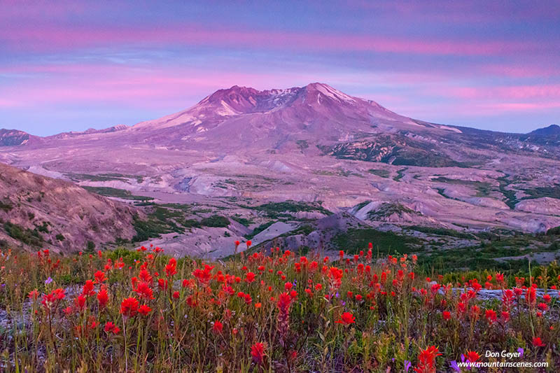
6.  Painted Hills Unit - John Day Fossil Beds NM


Painted Hills at sunset in the John Day Fossil National Monument, Oregon, USA.
Painted Hills at sunset.
 The Painted Hills Unit of John Day Fossil Beds National Monument is one of the most popular subjects in Oregon for landscape photographers. It is also the most well known of the unique formations within the monument.

Located near Mitchell, Oregon, the Painted Hills are a photographer's dream. They are colorful, patterned, contrasting, unique and extremely fascinating. Their colors change throughout the day and with even the most subtle change in light. They consist of stratifications of yellow, gold, black, and red as a result of layers of fallen volcanic ash from ancient volcanoes.  The Painted Hills are truly a photographer's delight!

7.  Artist's Palette - Death Valley National Park.

Artist's Palette in Death Valley National Park, California, USA.
Artist's Palette in Death Valley National Park.
Artist's Palette is on the face of the Black Mountains along Artist's Drive in Death Valley National Park.

As the name would suggest, it broadcasts an aray of attractive colors in its rock. The colors are brought on by the oxidation of different metals; red, pink and yellow is from iron salts, green is from decomposing mica, and the purple is from manganese.

The Artist's Drive area provides evidence of one of Death Valley's most violently explosive periods, though this is not the predominant thought on your mind while viewing these colors of the rainbow.

8.  In memory of Karen Sykes, 1945 - 2014

This is the saddest entry on the list.  The hiking community lost a truly special person and lover of life itself this year.


Image of Karen Sykes, courtesy Alan Bauer.
Karen Sykes, 1945 - 2014 (image courtesy Alan Bauer)
I first met Karen in 2007 - March 13th, 2007 to be exact.  It was a special day because it marked my first time hiking with her and another new friend, Alan Bauer.  Little did I know that both would become very good friends and colleagues.
On June 18th, Karen met her fate doing what she loved.  Her final adventure took place in Mount Rainier National Park, on a hike to Owyhigh Lakes with her boyfriend Bob.  Karen did not return. 

There are more questions than answers as to what happened on that day.  And most likely, many of those answers will never come.

I will miss Karen.  I will miss her joyous smile and infectious laugh.  I will miss her quest for adventure and seeking to notice details along the way that others might overlook.  I will miss her kind heart and goodwill to those around her whom she found so important in her life.

Rest in peace, Karen.  You have touched the lives of more than you ever could have imagined, and will be sorely missed.

9.  New Years Eve From Kerry Park!


The city of Seattle from Kerry Park on Queen Anne Hill, Seattle, Washington, USA.
Seattle cityscape from Kerry Park.
Kerry Park is one of, if not the, supreme view of the city skyline that Seattle has to offer, and includes the bonus of Mount Rainier off on the horizon. The visual is magical.

Access to the park was pretty straight forward and easy, even on such a day as New Year's Eve. It is certainly a popular spot, but as with many tourist locations, people come and people go. Too crowded for you? Wait 10-15 minutes.

Kerry Park is not very large. In fact, the "park" is mostly down below viewpoint, and requires a steep descent to visit. Kerry Park as photographers know it is more of a paved viewpoint, roughly 100 feet long. The best vantage if from the far west (right) end near the steps that descend to the play area and basketball court.

A visit to Kerry Park at sunset should be a must on every visitor's list. I strongly recommend it.
The park is located on Queen Anne hill, just west of Queen Anne Ave.

10.  Updated! New for the Holidays - Poster Prints!

Mount Rainier above flower meadows on Mazama Ridge near Paradise, Mount Rainier National Park, Washington, USA.I'm excited to share my newest product with you - poster prints! These 12x18 standard sized prints were created by my good friends at ADG Printing in Lynnwood just in time for the holidays and my upcoming shows! They represent 6 of my most popular images from my home state of Washington, and some personal favorites as well.


Well, that's it!  Now it's time to shed the past and move ahead to 2015.  I hope all your hopes and plans see fruition, and that it is a great year for everyone!

See you on the trail!


Tuesday, December 2, 2014

Note Cards for the Holidays!

If you are looking for note cards in time for the holidays, look no further!  I offer boxed note card sets from Mount Rainier National Park, Olympic National Park, North Cascades National Park, Mount St. Helens National Monument, and Mount Baker.  These are perfect for sharing the beauty of our beloved Pacific Northwest mountains!

These 6" x 4-1/2" folded notecards are printed on acid free, 100% cotton-fiber for archival quality, and are suitable for framing.  They are very elegant, and include mailing envelopes.

These sets are available for $12.00 per box, and can be viewed in detail and purchased here.

Happy Holidays!