I've just returned from Yosemite and Redwood National Park, and hope to have some images to share soon from this fun trip! I will also resume my posts on photographing Death Valley National Park. So much to do!
As always, thanks for your interest and I hope you will find the information I share to be informative and insightful.

Here's what is keeping me busy. Everything from hiking/climbing trips, photography trips, speaking engagements, art shows, new products, events, etc.
Sunday, April 10, 2011
Friday, April 1, 2011
Photographing Badwater in Death Valley National Park
 |
| Badwater salt polygons and Black Mountains |
Don't expect to be alone here in the evenings, but seek solace in the fact that the any crowds are easy to leave behind. How? By simply walking further out into the salt pan. The further you walk, the better the polygons become as you leave the wandering foot prints behind. By the way, evening light is fairly forgiving towards light footprints.
Most likely you will encounter other photographers along your walk, and it is fun to set your tripod up near one for some pleasant conversation and story sharing. Since you will be shooting either north or south and the foot path is east-west, it's pretty difficult to be in each others way.
 |
| Sunset over Badwater salt polygons |
Definitely consider the effects of the salt on your camera gear and clothes. They are very real and corrosive. Refrain from letting any of your camera gear come in direct contact with the salt, and be certain to clean your tripod feet and legs immediately after your shoot. Knee pads and/or a small sitting cloth is also recommended so that you don't have to kneel or sit directly on the salt.
The salt polygons are excellent to photograph in mornings or evenings. Evenings offer afternoon light on the Black Mountains to the east. Mornings offer brilliant light on Telescope Peak and the Panimint Range.
 |
| Early light on the Panimint Range above uplifted salt crusts near Badwater. |
Early mornings will also find you with limited company.
Just a 1/4 mile south of the Badwater parking lot the road rounds a Sharp bend and offers a wide shoulder for parking. A short walk leads the curious photographer to some very interesting uplifted salt crusts. I found these extremely photogenic with lots of compositional options incorporating the Panimint Range and Telescope Peak.
I spent two mornings here (alone), and two evenings at Badwater. I found this arrangement to work out well. I definitely recommend visiting this area multiple times during your visit. Another location, referred to as "devils fortune cookies" is located only a short distance further south (not obvious from the road, so you will need to scout).
 |
| Early light on Telescope Peak and the Panimint Range above uplifted salt crusts near Badwater. |
Normal range and wide-angle lenses are excellent for this area. Consider graduated neutral density filters a must, and a warming filter a friendly addition.
Badwater is located 18 miles south of Furnace Creek along CA 190. Allow yourself extra time for the walk out along the salt polygons or to scout the uplifted salt crusts. Most importantly, enjoy!
More images may be viewed in my Death Valley Gallery if interested.
More images may be viewed in my Death Valley Gallery if interested.
In closing, I must qualify all the information you just read above. During the winter of 2010/2011, floods apparently dissolved much of the polygons and salt crusts. My friend Jon Cornforth visited the area this spring and reported them to be gone, and that their return is expected to take a few years. I would encourage you to contact the park directly for specific information if planning a visit.
I will be leaving for Yosemite National Park and Redwood National Park shortly. I will continue my Death Valley posts upon my return, and hopefully have new images from my trip to share!
Friday, March 25, 2011
Photographing Devil's Golf Course in Death Valley National Park
 |
| Evening clouds over Devil's Golf Course. |
The Devil's Golf Course in Death Valley National Park is one of my favorite photography destinations in the park. The area is just so interesting and different than anything I have previously experienced. It's as if you've stepped onto another planet.
This magnificent place is accessed from the Badwater Road, 13 miles south from Furnace Creek. The area closest to the parking lot is not very attractive, having been trampled by many feet. But wander out a short ways and this will all change. The rounded salt crystal mounds will turn to sharp, serrated formations that are much more interesting.
Be warned: the salt crystals are very sharp and abrasive. Sturdy boots, gloves and knee pads are highly recommended.
I was surprised at how little traffic Devil's Golf Course received during my visits. It gets no where near the traffic that Badwater receives. I found most visitors to be car tourists who quickly read the information signs, took in the immediate surrounding of the heavily abused area near the parking lot, then sped off to their next destination. Very few remained longer than 10 minutes.
I spent a couple of evenings photographing this area, and found myself all alone at sunset both times. During my second evening another photographer did show up and explore areas close to the parking lot. After appearing frustrated, he packed up and drove off just before the prime light appeared!
 |
| Sunset over Devil's Golf Course. |
Devil's Golf Course is a great location for wide angle and normal range lenses. Getting low with your tripod can be a little challenging, both in the positioning of your tripod legs and being able to get low enough to compose your shot through the view finder. Don't expect to be comfortable! But do expect the rewards to be worth it.
A telephoto lens would be useful to play with the patterns, though I did not do this. Do you get the feel that there is just so much potential here?
Graduated neutral density filters should be considered mandatory. I would also consider a warming filter if you don't have access to this during post-processing.
I found evening to be the best time to photograph here, though mornings could still be rewarding as well. Though the southern sky is typically considered the most rewarding for pinks and interesting colors, both images appearing here are actually of the northern sky. Also, watch the Black Mountains at sunset and the Panimint Range at sunrise as these respective mountain ranges catch the suns special light.
I highly recommend making Devil's Golf Course part of your itinerary during your next Death Valley National Park visit.
Friday, March 18, 2011
2011 Washington State Visitors' Guide
 |
| Good friends Alan Bauer and Kim Brown on Steamboat Rock. |
This image is from the first trip that Alan and I did together, and was full of fun memories. One of those memories was unexpectedly meeting Kim at the trailhead, and her joining us on our trek up Steamboat Rock. This was also the trip I first met another friend, Karen Sykes - who reviewed my book Mount Rainier for the Seattle Post-Intelligencer. Did I mention how fun this trip was?
Oh, but it get's even more interesting!
 |
| 2011 Washington State Visitors' Guide |
Unbeknownst to me when agreeing to submit this image, it would accompany an article written by another friend and accomplished writer, Craig Romano - a mutual friend to all of us!
If you get a chance, check out the free online version.
If you get a chance, check out the free online version.
Here's to more future trips and projects together!
Wednesday, March 16, 2011
Death Valley National Park Gallery
 |
| Early light on Manly Beacon from Zabriske Point |
Puting this gallery together brought back a lot of memories for me, and I hope you find an image or two that touch you or maybe kindle your desire to visit this wonderful national park yourself.
 |
| Sliding rock at The Racetrack |
I wish to take the time to say Thank You once again for your interest in my photography and endeavers. As always, I am happy to answer your questions - either about photography or helping plan your own visit to any of the wonderful places I share on these pages.
Sunday, March 6, 2011
Spring Appearances Cancelled
Just a note: I've elected to cancel my scheduled spring appearances in order to focus on some business projects. I will surely have shows to announce later in the year - stay tuned. Thank you for your understanding.
Thursday, March 3, 2011
Shi Shi Beach and Point of the Arches - Olympic National Park
Winter isn't the time that most people think of visiting the coast. After all, there's snow in the mountains and plenty of skiing, snowboarding and snowshoeing to do. However, winter does offer some advantages (including having all those people in the mountains skiing, snowboarding and snowshoeing!). The sun is further to the south in the winter months, offering softer light for a larger part of the day, and low and high tides tend to be more extreme. With this knowledge in hand, a photographer can employ much creativity while exploring options not necessarily available to visitors later in the season.
Of course, there are some downsides to visiting in winter as well, starting with temperatures. My visit took place with snow in the forecast and temps in the 20's. For Shi Shi in particular, this made the approach interesting with an icy boardwalk section and an icy crossing of Petroleum Creek. Couple cold temps with the moisture present in the air, and it is very easy to get chilled to your core. I strongly recommend a layer system and several extra pairs of socks.
As for camping, make sure you set your campsite in the trees. While camping on the beach can be an attractive option in the summer, I can tell you firsthand that not much, if any, of the beach is safe in winter. High tide can make much of the beach impassable in the winter months.
From a photography standpoint, if you have visited Shi Shi in the spring, summer or fall, you may have some adjusting to do when planning your compositions. Did I mention that the sun sets much further to the south? Much further than I anticipated I will admit. Still, as long as you plan for this, there can be rewards.
The tidal pools around Point of the Arches are some of the best I have seen on the Washington coast. Though they can be enjoyed in all seasons, the extreme low tides of winter make even more of them accessible and allow for further exploration. But don't spend all of your time looking down. Bald Eagles can be regularly seen flying overhead and even perching in the trees above the arches themselves. Sea otters are also a common and fun sight.
Campsights near the Point of the Arches can be ideal for quick and easy access. Camps around Petroleum Creek afford a nice composition of having the winter sun set behind the sea stacks, with its light seen through two separate arches.
Raccoons must be reckoned with. I've never experienced them in previous visits, but they were certainly present during my last visit. Though I had a visitor at my camp near the point, they seemed concentrated around the campsites at the very north end (beginning) of Shi Shi Beach. Remember that a hard food container is required (see the Olympic National Park web site).
For lenses, I found my 24-70mm most useful for landscape, and 70-200mm with 2x extender for tidal pools and wildlife. Though I brought my 17-40mm, it never saw the light of the day on this visit. Graduated neuatral density filters and polarizers are also important.
I hope you get a chance to visit our coast during its "off season". I think you will enjoy it.
If you are interested in further viewing, I have other images from this area as well as Rialto Beach, Hole in the Wall, Ruby Beach, Strawberry Point, Toleak Point, Cape Alava and more in my Washington Coast gallery.
 |
| Point of the Arches at the south end of Shi Shi Beach |
 |
| Sunset at Point of the Arches |
As for camping, make sure you set your campsite in the trees. While camping on the beach can be an attractive option in the summer, I can tell you firsthand that not much, if any, of the beach is safe in winter. High tide can make much of the beach impassable in the winter months.
 |
| Sunset at Point of the Arches |
From a photography standpoint, if you have visited Shi Shi in the spring, summer or fall, you may have some adjusting to do when planning your compositions. Did I mention that the sun sets much further to the south? Much further than I anticipated I will admit. Still, as long as you plan for this, there can be rewards.
The tidal pools around Point of the Arches are some of the best I have seen on the Washington coast. Though they can be enjoyed in all seasons, the extreme low tides of winter make even more of them accessible and allow for further exploration. But don't spend all of your time looking down. Bald Eagles can be regularly seen flying overhead and even perching in the trees above the arches themselves. Sea otters are also a common and fun sight.
 |
| Point of the Arches at dawn. |
Raccoons must be reckoned with. I've never experienced them in previous visits, but they were certainly present during my last visit. Though I had a visitor at my camp near the point, they seemed concentrated around the campsites at the very north end (beginning) of Shi Shi Beach. Remember that a hard food container is required (see the Olympic National Park web site).
For lenses, I found my 24-70mm most useful for landscape, and 70-200mm with 2x extender for tidal pools and wildlife. Though I brought my 17-40mm, it never saw the light of the day on this visit. Graduated neuatral density filters and polarizers are also important.
I hope you get a chance to visit our coast during its "off season". I think you will enjoy it.
If you are interested in further viewing, I have other images from this area as well as Rialto Beach, Hole in the Wall, Ruby Beach, Strawberry Point, Toleak Point, Cape Alava and more in my Washington Coast gallery.
Monday, February 21, 2011
2011 Greater Seattle InfoGuide

The InfoGuide is a great publication to pick up if you are looking for things to get out and do, and is available at most hotels and tourist destinations around the greater Puget Sound area.
Wednesday, February 16, 2011
Photographing Yellowstone National Park
 |
| Canary Spring |
Yellowstone National Park is an amazing place for photography. There is so much variety available that something is bound to capture the interest of most shutterbugs. The park has very distinct features, offering geysers, hot springs, waterfalls, terraces and mud pots. Each of these features require a slightly different approach with the camera.
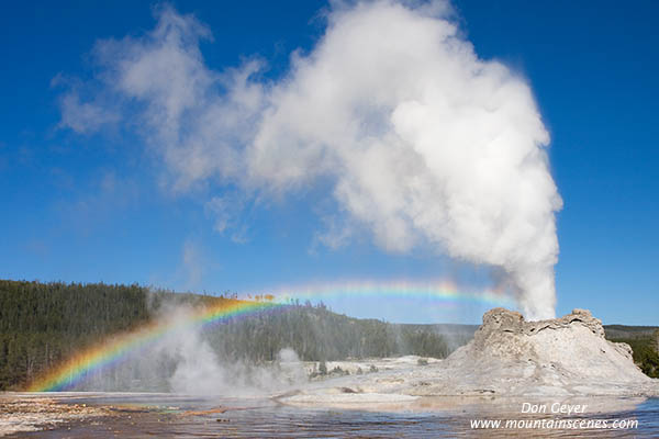 |
| Castle Geyser and rainbow. |
Morning is a great time to photograph wildlife throughout the park, reflections in the Firehole River and around Fountain Flat, and of course both Upper Falls and Lower Falls of the Yellowstone River.

 |
| Lower Falls and rainbow. |
To my disappointment, Tower Falls was not available during my visit. Nor was Gibbons Falls - both due to construction.
Rustic Falls, north of Mammoth Hot Springs, is quite nice. But it is north facing so the sun never hits all of it. It is best photographed on a cloudy day for even light.
Another waterfall worth checking out is Undine Falls, in the north section of the park. This might be a better autumn picture.
 |
| Crested Pool |
 |
| Old Faithful |
Obviously, you don't want to be shooting in the direction of the sun. Likewise, you don't want to be down wind of the erupting geyser! Understanding the direction the geyser will erupt will allow you to plan your composition, rather than be reacting to the elements.
Know the estimated schedule for each geyser's eruption ahead of time. This will put you in the best possible position to succeed. Schedules are available as handouts at the visitor center, posted at most of the geysers, and available on the park's web site.
One last word on the geysers is to study interesting forefronts that will add uniqueness to your composition and make your image stand out.
 |
| White Dome Geyser at sunset |
Sunset can also be a fun time to shoot the geysers. Again, knowing their schedule is important. Here, White Dome Geyser was scheduled to erupt shortly before sunset. However, it was an hour late and its eruption timed perfectly with the evening light, allowing the setting sun to turn its plume pink!
I hope you have enjoyed these basic hints for photographing Yellowstone National Park. Feel free to contact me with your questions if planning a visit of your own. I am always happy to help!
Many more images are available for viewing in my Yellowstone gallery.
Many more images are available for viewing in my Yellowstone gallery.
Friday, February 11, 2011
Visiting the Oak Creek Wildlife Area
The Oak Creek Wildlife Area encompasses 47,200 acres in Yakima County, just outside the town of Naches, Washington (15 miles west of Yakima). It's a winter viewing and feeding area for both Rocky Mountain elk and California big horn sheep, and was established to resolve the conflict between these animals in search of winter food and private land owners, orchard growers, and livestock producers.
 |
| A bull Rocky Mountain elk stands watch. |
 |
| Rocky Mountain elk issues a challenge to nearby bull elk. |
 |
| Rocky Mountain elk playfully spar. |
 |
| Rocky Mountain elk stand alert. |
 |
| A Rocky Mountain elk anticipates feeding time. |
I recommend arriving here around 10:30, right after the feeding of the big horn sheep (once they are fed there isn't much reason to stick around). The first tour truck departs at 11:00 am. They then run every hour, or half hour depending on the demand. Sign-ups are in the visitors' center and can fill up fast. You can also call ahead and reserve your group's spot on the trucks. Information is available at their web site, as well as information and directions to other viewing spots within the Oak Creek Wildlife Area.
 |
| Guided tour at Oak Creek Wildlife Area. |
The tour trucks each hold a little over a dozen people. They drive out into the middle of the herd and park for 15-20 minutes, engine off. At this point people can move around freely on the truck for optimum viewing. I highly recommend the tour as a means to get closer to the animals and to be able to photograph them in a more natural setting (vs. having fences and barns in your background). The tour guides are always very informative too, and I have learned something new on each visit. Though the tours are free, please don't forget to offer your donation. It's your money that keeps this program going.
 |
| Oak Creek feed truck prepares for food drop. |
This is a winter feeding program only, and numbers of animals can vary from year to year depending on the harshness of winter. Numbers were way down this year during my visit, sporting only 670 elk vs. the 1,000+ I have seen other years. However, this decrease actually made it easier to photograph them, offering easier isolation of the animals.
 |
| A feed truck makes it's way through the herd at Oak Creek. |
January and February are the best months to view these animals. December is too early due to its closeness to hunting season; the animals are still quite nervous and stressed. It is not uncommon to see maimed animals. A three-legged cow has been present the past four years. Unable to run or even walk fast, I'm amazed at her resiliency.
Oak Creek Wildlife Area is a place you want to visit and take the family. I return each year with my kids in tow, and they absolutely love it. Try it - you'll be hooked!
Sunday, February 6, 2011
Mormon Row in Grand Teton National Park
 Mormon Row is located just off Antelope Flats Road, and consists of four abandoned old barns. The barns serve as excellent foreground material when photographing the Cathedral Group of the Tetons, which consists of Grand Teton, Owens and Teewinott.
Spring is actually considered to be the best time to photograph these barns. The mountains still have interesting patches of snow on them, and the side lighting is stronger for better detail. Autumn sees much flatter light at sunrise.
 Of course, my visit took place during autumn, so I had to deal with the hand I was dealt. I still enjoyed photographing from this location - enough so that I returned for sunrise after shooting in late-morning the previous day. The barn up top is probably the most photogenic of all the barns, and makes a great sunrise to mid-morning subject.
I found mid to late morning to also be quite interesting, and for more than just the barns. There are also numerous fences, gates and corrals available to frame the Cathedral Group with.
 One can easily spend a full morning at Mormon Row, and still have reason to come back. Maybe you will photograph the barns on the north side of Antelope Flats Road one day, and the ones to the south on another day. Or maybe you will simply return with fresh ideas to try after reviewing your initial images. However way you choose to explore this historic area of Grand Teton National Park, enjoy!
 I have recently completed my new Grand Teton National Park gallery, and have made it available for viewing. It includes my visits to Schwabacher Landing, Oxbow Bend, Triangle X Ranch, Mormon Row, and many places in between!
Wednesday, February 2, 2011
Oxbow Bend in Grand Teton National Park
 Oxbow Bend is considered to be one of the prime photographic destinations within Grand Teton National Park. Located just 3 miles inside the entrance, it's still waters can offer a beautiful reflection of Mount Moran and surrounding peaks, and can be the scene of dramatic sunsets should clouds be present in the evening.
This body of water was formerly a portion of the Snake River that has been bypassed and has formed a lake. The results are very pleasing to the eye and attract photographers and tourists alike!
 Photographers would do well to arrive early for sunrise. After my experience at Schwabacher Landing the day prior, I made certain to arrive at Oxbow Bend 1-1/2 hours before sunrise. I was alone much of this time! I would still recommend an hour early (as I would with any sunrise). The great thing about Oxbow Bend is that it offers a very large area for photography, unlike Schwabacker Landing. Photographers can set up in the parking lot or along the 1/4 mile of road to the west. Personally, I recommend staying close to the parking lot. I also found my best shots to be from mid to late morning. Early morning light in autumn is very flat here.
 Plan on spending much of the morning here as there is a lot to do! After first light on Mount Moran, you'll have some dead time until the foreground begins to light up. As the morning moves on, I recommend moving further up the road.
There are many other posibilities as well. Above the road to the north is a trail that is frequented by horseback riders. Wandering along and near this trail offers all kinds of compositions not available from the road.
 If your lucky, you might even come across a guided horse tour as I did. I created several compositions of the group of riders, but really like the isolation of this lone rider.
There are many other wanderings available in the area as well. Don't be in a rush to get back to camp!
When you are done, don't miss driving 1 mile further up the road to Jackson Lake Junction and visiting the viewpoint. While it doesn't offer much for photography, it's a pretty incredible panorama.
Next up: Mormon Row!
Subscribe to:
Posts (Atom)