Sunday, April 14, 2019

Mount Robson Provincial Park

Mount Robson reflected in Berg Lake, Mount Robson Provincial Park, British Columbia, Canada.
Mount Robson reflected in Berg Lake.
In my opinion, Berg Lake at the foot of Mount Robson in Mount Robson Provincial Park is one of the absolute highlights of the Canadian Rockies.  The Berg Glacier tumbles down from the uppermost reaches of the mountain, terminating at the side of the lake.  The constant rumbling you hear throughout the day and night (sometimes quite loud) is the ice from the glacier calving into the lake.  This classic view is just a few short steps from your tent site!

Much like Lake Magog in Mount Assiniboine Provincial Park, getting here involves a long hike in, or scheduling a helicopter ride on one of the two days a week they are allowed to land.

A base camp at Berg Lake offers several exceptional hiking opportunities to explore the area beyond the lake, including Mumm Basin, Hargreaves Glacier, Toboggan Falls and my favorite, Snowbird Pass.

This image is currently appearing on a tourism website.  You can see this image and many more from this area by visiting my Canadian Rockies Gallery.

As always, thanks for looking!

Saturday, April 6, 2019

Mount Assiniboine Provincial Park

Mount Assiniboine above fall larch near Lake Magog, Mount Assiniboine Provincial Park, British Columbia, Canada.
Mount Assiniboine above larch beginning to turn color.
I have been visiting Mount Assiniboine Provincial Park for many years now, and have come back with some of the most memorable experiences with each and every visit!  These memories include trudging through a foot plus of snow in September, mice infested cabins the one time I took my wife (our anniversary!), a mother grizzly bear and cub flattening my unattended tent, and more!  Yes, Assiniboine holds a special place in my heart.

This image was taken on my very first trip into Assiniboine.  It was mid-September and the larch had just started to turn.  It was a cold visit and we had it mostly to ourselves.  We packed in a tent with plans to stay in the campground, but arrived to find over a foot of snow on the ground and elected instead to stay in one of the Naiset Huts, which were mostly unoccupied and readily available.  Such would most likely not be the case today.  The huts are now reservable and booked well in advance.  Assiniboine has also seen a dramatic increase in popularity as more people are drawn to the "Matterhorn of the Canadian Rockies".

While popularity has gained, it still is nothing close to most national parks and I highly recommend a visit.  It's a 17 mile hike in, or helicopter flight, or tandem there of (including having your gear flown in while you do the hike).

For lodging, there is the campground, the Naiset Huts, or the Assiniboine Lodge itself!

This image is currently appearing in an internationally distributed wall calendar by a Japanese manufacturer.

To view more images from the Canadian Rockies - both National Parks and Provincial Parks, feel free to visit my Canadian Rockies Gallery.

As always, thanks for looking!


Monday, March 4, 2019

The Picket Range in North Cascades National Park

The Southern Picket Range as seen from above Luna Saddle in North Cascades National Park, Washington, USA
The Southern Picket Range, North Cascades National Park
The Picket Range of the North Cascades remains the wildest region in the North Cascades.  There are no easy approaches, and most all approaches involve heavy bushwhacking, stream crossings and challenging route-finding.  But for the seasoned climber willing to take on the challenge, the Pickets can be a spectacular place from which lifetime memories can be made.

The Picket Range is divided into two groups - the northern and southern groups.  While both provide challenging approaches, the northern group's are substantially longer and most challenging.

I've been fortunate enough to have spent considerable time in both groups.  While not always successful, the memories of friendships, challenges, celebrations, and defeat that I've brought back live with me forever.

I have fond memories of high camps on Easy Ridge on the approach to Mount Challenger, and camps in Terror Basin while ascending McMillan Spire.

But my most memorable trip was the one in which this image was taken.  It involved taking a boat taxi up Ross Lake to Big Beaver Landing and hiking 10 miles up the Big Beaver Trail.  From here, we "turned off the paved road", venturing cross-country to the raging river known as Access Creek and nervously crossing it on a wet log ever so diligently and greeted by one of the worst bushwhacks I've ever experienced.  The rewards that awaited us were many, with some of the most fantastic high camps I've ever enjoyed.  We climbed both Luna Peak and Mount Fury (East Peak) on this trip, and had hopes of climbing many more as we traversed to the Southern Pickets and exit via Goodell Creek.  We didn't make it to the Southern Pickets this trip, unfortunately.  As often happens, we encountered unforeseen challenges that would require additional time to navigate - challenges we hadn't budgeted time for.  Still, in the arms of defeat, this was a pretty special trip!

The image above was taken from a camp above Luna Saddle, and is currently appearing in a German travel brochure.  While morning photography often involves waking up well before sunset and scampering up some ridge in the dark, such was not the case here.  It was our view from our sleeping bags!

I hope you enjoy.  If you wish to see more images from this area, I invite you to visit my North Cascades Gallery.

As always, thanks for looking!

Saturday, February 16, 2019

Wildflowers at Mount St. Helens

Mount St. Helens above meadows of lupine in Pumice Plain, Mount St. Helens National Volcanic Monument, Washington, USA.
Lupine in bloom in Pumice Plain below Mount St. Helens.
When most people think wildflowers in Washington state, they immediately think of Mount Rainier.  And why not?  The area is spectacular!  But further to the south, more people are starting to discover colorful flower displays scattered around Mount St. Helens.

Johnston Ridge is the most obvious and easiest to get to.  Wildflowers can be viewed by the parking lot or on short paved path to an amphitheater behind the visitor center.  For more easy views, the Boundary Trail can be walked below the visitor center from a pullout before the Visitors Center.  For the more ambitious, hike the Boundary Trail east from the Visitor's Center towards the Truman Trail.  All excellent choices, and typically prime in early to mid-July.

If you want to escape the crowds a bit, head to Windy Ridge on the NE side of the mountain.  Again, roadside displays are readily available.  But even better displays await those willing to stretch their legs.  Norway Pass is a famous viewpoint overlooking St. Helens above Spirit Lake.  An eruption of colors can be found along this section of the Boundary Trail, as well as the Independence Ridge Trail.  For the best experience, make this a loop trip, hiking counterclockwise!

From the south side of the Windy Ridge parking lot, walk around the locked gate and walk the former logging road south to the Truman-Abraham Saddle.  Here there are choice to be had (and you can't go wrong with either!).  For flowers, continue walking the road downhill, now known as the Truman Trail, to hook up with the Windy Trail.  Turn right.  In early to mid-June, lavender colored slopes will greet you on Pumice Plain, and if arriving at peak, the aroma of lupine may overtake your senses.

The above image was taken along the Windy Trail along Pumice Plain, after shooting sunrise from the Truman-Abraham Saddle.  A prominent lenticular cloud had been present off the top of the mountain at sunset, but had mostly dissipated by mid morning, when this shot was taken.

This image is currently being used in a keynote presentation by a prominent local technology corporation here in Washington.

Saturday, December 29, 2018

Snoqualmie Falls In Winter

Snoqualmie Falls in winter amidst a winter wonderland, Snoqualmie, Washington
Snoqualmie Falls in winter from the lower viewpoint
I'm pleased to announce that this special image of Snoqualmie Falls, taken during an exceptional December cold spell, will be used by Seattle University for a "Mountains to Sound" course they are teaching this winter, which focuses on the geology of the I-90 corridor.  Students will even be visiting the falls mid-course - hopefully it won't be this icy!

This image was taken at sunrise during a particularly harsh December cold spell, causing the spray of the falls to freeze against the surrounding rock and creating a true winter wonderland!

Snoqualmie Falls is one of Washington states most scenic attractions, with 1.5 million visitors annually.  This dramatic 270 foot waterfall is a sight to behold as it plunges to a pool of the Snoqualmie River below.

The best views, in my opinion, are from the observation deck, only 200 feet from the parking lot.  However, the interesting alternate scene pictured here can be viewed by hiking the path down to the base of the falls, or finding the lower parking lot off SE Fish Hatchery Road.

This is one of many images I have taken of Snoqualmie Falls.  If you wish to view more, please feel free to visit my Snoqualmie Falls Gallery.

As always, thanks for looking, and enjoy your winter!

Wednesday, December 26, 2018

Ptarmigan Tunnel - Glacier National Park

A hiker ascends the steep, exposed Ptarmigan Tunnel Trail in Glacier National Park, Montana.
Greg Moo makes the final ascent to Ptarmigan Tunnel from Elizabeth Lake
in Glacier National Park, Montana.
This image is from the end of an incredible week long trip in Glaicier National Park in Montana.  It's referred to as The North Circle, typically beginning and ending at Many Glacier.  However, we elected to start at Logan Pass and end at Many Glacier (with a shuttle back to Logan Pass).

Our variation of this fantastic trip had us visiting such sights as The Garden Wall, Granite Park, Fifty Mountain, Sue Bench, Stoney Indian Pass & Lake, Belly River, Glenns Lake, Mokowanis River & Lake, Elizabeth Lake, Dawn Mist Falls and Ptarmigan Tunnel, and more!  It's a trip that will live in my mind forever, and one that I would like to do again someday.

This image captured my hiking partner, Greg Moo, as we made our final ascent up the trail to Ptarmigan Tunnel.  This section of trail on the north side of the tunnel was blasted from the rock in 1931 as a means to access the Belly River drainage from Swiftcurrent.  This image was recently published in a worldwide design publication.

You can view more images from this wonderful national park in my Glacier National Park Gallery.

As always, thanks for looking!


Thursday, November 22, 2018

2019 Mount Rainier Wall Calendar

2018 Mount Rainier wall calendar by Don Geyer
2018 Mount Rainier wall calendar
Great news!  My new 2019 Mount Rainier wall calendar is now out and available for order!  It includes some of my favorite images from around the park, including Paradise, Tipsoo Lake, Spray Park, Mazama Ridge, Moraine Park, Sunset Park, Tatoosh Range, and more!

The calendar is available for purchase for $10.99 plus shipping.

I am also working on another Western Landscapes calendar for 2019, which will include images from all over the western U.S. and Canada.  I hope to have an announcement in the next day or two of its completion!

If you wish to view more of my work, please feel free to visit my website at www.mountainscenes.com.

As always, thanks for looking!


Saturday, October 13, 2018

Mount Rainier NP in Fall


Mount Rainier above the bright red meadows of Paradise Park in fall, Mount Rainier National Park, Washington.
Mount Rainier National Park has always been a favorite fall color destination for me, offering a smorgasbord of reds, yellows and oranges any given year.  But this year there were some concerns about how these colors might unfold due to the hot, dry summer.  Typically such conditions stress the plants and do not result in the best autumn show.

Well, all worries went out the window around the last week of September when the colors  began to pop!

Mount Rainier above the bright red meadows of Paradise Park in fall, Mount Rainier National Park, Washington.
The most popular destination for fall colors in the park is Paradise Park above the Paradise Visitor Center.  Here the intense colors start at the parking lot and continue up several hundred feet through the meadows.  Hikers can walk the paved trails to Edith Creek, Nisqually Vista or Alta Vista - or all the above!

The wanderings can be endless and slow going during peak season as around every corner a different array of color combinations present themselves.

Image of a black bear in the fall foliage of Paradise Park, Mount Rainier National Park, Washington.
As you wander, keep your eyes open for wildlife. Chipmunks, marmots and pikas are numerous and will typically announce your presence. Deer are a common sight as well. Also, it is not uncommon to see black bear in the bushes feasting on the huckleberries as they try to fatten up for their winter slumber (always keep a safe distance away).

There are other nearby places for the casual visitor to enjoy fall colors as well, and with less crowds.  The Lakes Trail provides a beautiful hike through red foliage while visiting several small tarns.  Most of the colors are lower down near Reflection Lake, not on Mazama Ridge.

Mount Rainier above the bright red meadows of Paradise Park in fall, Mount Rainier National Park, Washington.
The trail to Bench Lake is another excellent area to enjoy the colors and views of the mountain.  Colors are reached just a short distance from the trailhead in wide open meadows.

Further away, Tipsoo Lake is also a splendid area to enjoy roadside fall colors.  Short hikes in the area offer further explorations.

Fall is probably my favorite season to be in the outdoors.  While the days can be warm, the nights can be crisp (as can early mornings and late evenings).  Be sure to have warm clothes with you!

Mount Rainier above the bright red meadows of Paradise Park in fall, Mount Rainier National Park, Washington.
All the images accompanying this story were taken this year - about 2 weeks prior to this writing, in fact.  To see more of these images, as well as images of the other areas I have mentioned, visit my Mount Rainier Gallery.

As always, thanks for looking!  Hope to see you on the trail!

Monday, July 30, 2018

My Little Hiker

A young hiker pauses along the Kautz Creek trail in Mount Rainier National Park, Washington.
A young hiker on the Kautz Creek Trail, Mount
Rainier National Park.
Backpacking with your kids can be so rewarding, especially if they are truly enjoying the experience.  This image of my son was taken on his second backpack, a trip up to Indian Henry's Hunting Ground in Mount Rainier National Park.

We approached Indian Henry's via the Kautz Creek Trail, which admittedly was much longer than I remembered (I've always snuck in via the Tahoma Creek route).  It was a tiresome day for him, but he never got down - what a trooper!

Camp at Devil's Dream was a welcome reward for him, and allowed him to rest up for our evening adventure - a photography excursion back up to Indian Henry's.  Oh, did I say photography excursion?  Well, maybe for one of us.  But for the other it was learning that frogs exist in those tarns and could be fun to try and catch!  He was never actually successful, but that didn't matter.

My son is 12 now, and has outgrown these hiking boots many times over.  But the memories of the earlier years still put a smile on my face.

This image was recently licensed to appear as a full page layout in a book being published in Spain.  Fun to be able to share the memory with so many others!

Monday, June 18, 2018

Valley of the Gods


Image of Valley of the Gods, Utah
Tucked away in the far southeast corner of Utah is the very scenic and remote Valley of the Gods.  This scenic gem is very similar to nearby Monument Valley, but on a smaller scale and without all the strict tribal regulations and commercialism.  It offers isolated buttes, towering pinnacles and wide open spaces for wandering and exploring.

Located off Highways 163 and 261, the nearest town is Mexican Hat, population 31 (as of 2010), offering a 7/11 gas station as its only service.

Valley of the Gods was formerly part of Bears Ears National Monument, but lost that status in 2017 with the changing of the monument's boundaries.  It now resides on BLM land.  There are no official trails or campgrounds, but both hiking and private camping are very much available.

A 17-mile dirt and gravel road (FR 242) winds through the valley, stemming between Highways 163 and 261.  It's a relatively well-groomed road, but does have some bumpy and steep sections.  In dry conditions the road is easily travelled by regular vehicles.  But after heavy rains, a 4x4 might be necessary.

Valley of the Gods, Utah.
The valley is home to such landmarks as Lady in the Bathtub (Balanced Rock), Rudolph and Santa Claus, Castle Butte, Battleship Rock, Setting Hen Butte, Rooster Butte, Seven Sailors and more.  It doesn't take much imagination to see the resemblance of each formation to their name.  Conveniently, FR 242 winds amongst them and offers great access to up-close viewing points.

The red sandstone rock in the valley is extremely photogenic and turns a brilliant red at sunset.  Mornings can be quite nice as well.

Battleship Butte in Valley of the Gods, Utah.
The valley can be entered at two locations.  If driving from the east on Highway 163, the entrance is an easily missed turnout to the right with a small "Valley of the Gods" forest service sign.

If arriving from the north via Highway 261 at the base of the spectacular Moki Dugway, the entrance is much more obvious with a large pull-out, bulletin board and entrance sign, and a bed and breakfast shortly up the road.

Valley of the Gods, Utah.
If arriving in the morning, I would recommend starting at the east entrance.  In the afternoon, the west entrance would be the better choice.  This puts the sun to your back rather than looking straight into it.

There are numerous pullouts along the road for extended viewing and photography opportunities, as well as camping.  Surprisingly, you will find mostly solitude along this road.  This valley offers a much more peaceful setting than its more famous neighbor 30 miles to the south - Monument Valley.

Valley of the Gods, Utah.
Photo Advise:  You can probably leave the wide-angle lens at home for this one.  Much more useful will be your standard and telephoto lenses.

While the entire stretch of road is quite scenic, I found the northern section of the valley to be my favorite.  With campsite pullouts all along the road, it is easy to scout out desirable photography locations and then find a place to camp very near by.

This would likely be a prime destination for night photography as well.  Unfortunately, I had cloudy skies at night during my short visit - another reason for a return trip!

Keep in mind that you must be totally self-sufficient photography wise when visiting this area.  If you forget to bring something, it is a long drive to find photography supplies.

Finally, this can be a dusty area and you will want to protect your camera gear accordingly.

Rooster & Setting Hen Buttes in Valley of the Gods, Utah.
When you are ready for a change of pace, there are plenty of other options available nearby.  For starters, I highly recommend turning right on Highway 261 at the west entrance and driving up the Moki Dugeway.  This highway switchbacks up the cliff face 1,100' to the top of Cedar Mesa!  It's a slow traveling gravel road, with 3 miles of hairpin turns.  From the top you have a spectacular birds-eye view of Valley of the Gods and Monument Valley further off in the distance.  There's not much for photography here, but the views are must see!

Monument Valley is about 30 miles to the south with incredible monoliths that vastly outshine those of Valley of the Gods.  Unfortunately, with it come large crowds, strict regulations, and commercialism around every bend with roadside trinket stands, commercial photo offerings, etc.  While the scenery was spectacular, I found it a hard pill to swallow after enjoying the serenity of Valley of the Gods.  I would recommend visiting here first if you choose to do so.

The San Juan River meanders through Goosenecks State Park, Utah.
The San Juan River meanders through Goosenecks State Park.
Only a couple miles down the road from Valley of the God's west entrance is Goosenecks State Park.  Here the San Juan River meanders for over 7 miles, while only traveling less than 2 miles!  Designated campsites are available along the rim, with excellent views of this triple gooseneck.  No matter what size wide-angle lens you have, it is not possible to get them all in a single shot, unless using aerial means.

The San Juan River meanders through Goosenecks State Park, Utah.
Panorama of the San Juan River from Goosenecks State Park.


You can see more of my images from Utah and the southwest in my Southwest Gallery.  As always, thanks for looking! 


Sunday, April 1, 2018

Newly Updated Southwest Gallery!

Mesa Arch, Canyonlands National Park
 I have FINALLY finished updating my Southwest Gallery on my website.  I'm proud to say it is finally up-to-date, and includes images from all my visits to national parks, state parks, national monuments and recreation areas.

I've enjoyed several trips to the southwest over the years, yet I just can't get enough of the area.  While I have visited most of southern Utah and some of Arizona, I still have so much more to see (and will be very soon).

Here are some of my favorites.

Soda Springs Basin, Canyonlands National Park
Canyonlands National Park near Moab, UT is a fantastic park to visit, and much less crowded than its neighbor to the north, Arches National Park.  It is comprised of three districts - Island in the Sky, The Needles and The Maze. 

Island in the Sky is by far the most popular and accessible.  It provides access to Mesa Arch (pictured above), Grandview Point, White Rim Overlook, Green River Overlook, Murphy Point and more.  These are all accessible by car or short walks.

Don't forget to visit Dead Horse State Park while in the area.  It is reached via a spur road just before the Island in the Sky entrance, and offers amazing views that will rival anything in Canyonlands!

Gooseneck, Dead Horse State Park.
The Needles District can be accessed by car, but its best offerings are from the trail, including a hike into Chesler Park.

The Maze is 4X4 or mountain bike country and is visited much less.

Practically across the highway from the Island in the Sky district of Canyonlands is Arches National Park.  There are many things to see along the road into the park, starting with Park Avenue and the Courthouse Towers.  These require a short hike to be fully enjoyed, though it is quite easy (and can be made a one-way hike, all downhill, with a second vehicle).


Delicate Arch, Arches National Park
Next up is Balanced Rock is just off the road a little further, and can be enjoyed from a picnic area.

Delicate Arch, the state icon, can be reached by a 3 mile trail to the fantastic viewpoint.  Be prepared for the crowds, but understand the area is large and accommodating.

Fiery Furnace is a maze of confusing narrow canyons.  Ranger led tours through this labyrinth are recommended, at least for your first visit.

Balanced Rock, Arches National Park
At the end of the road is the trailhead to The Devil's Garden.  This trail accesses Landscape Arch, Navajo Arch, Double O Arch, and many more.

5 miles east of Escalante, UT is Hole in the Rock Road.  This is the main access to Grand Staircase - Escalante National Monument.  There are several popular slot canyons to hike along the road, and also sports its own Devil's Garden (not to be confused with Arches).  The first 12 miles of this road are suitable for cars, as long as weather conditions are nice.

Calf Creek Falls, Grand Staircase - Escalante NM


Also near the town of Escalante is a short hike to a wonderful waterfall, Calf Creek Falls.  This waterfall has a beautiful pool at its base, making the hike quite popular on a hot day.  It also sports a fair amount of poison ivy, which I have yet to be successful in avoiding!

Scenic Byway 12  is an incredibly scenic road that connects Escalante and Boulder, UT.  This section passes through some of the most incredible scenery Utah has to offer and always ranks among the top scenic drives in America.  It's not to be missed!

Bryce Canyon National Park is beloved by most all.  It offers easy access to prominent overlooks along its rim,  and excellent hikes down into the canyon that add to the experience for those wanting more.

Sunrise and Sunset Viewpoints are easily accessed from the parking lot.  Sunset Point is probably the best spot to view Bryce Canyon - and is also the most popular.  A little further south is Inspiration Point, which requires about a twenty minute walk.
The Cathedral, Bryce Canyon National Park

To really experience Bryce Canyon, I highly recommend descending down into the amphitheater and wander amongst the hoodoos.  Two popular trails to do so on are the Queen's Garden Trail and the Navajo Trail.  You can connect these two trails for an even better experience, and enjoy the sights of Thor's Hammer, Wall Street and The Queens Garden in one enjoyable stroll!

Fairyland Viewpoint, Yovmipai Point and Rainbow Point are also nice visits, though much different.

The light on the hoodoos changes drastically throughout the day.  This place should be experienced in both early morning and late afternoon to see it at its best.

Oh, and don't forget to visit Red Canyon just outside Bryce NP!

The Temple of Sinawava, Zion National Park
Zion National Park is a much different park than those already discussed.  It basically consists of two areas - the canyon and the plateau.  The plateau is easily viewed by car and incredibly scenic, especially around Checkerboard Mesa.

The canyon is also extremely scenic, but lends itself more to hiking.  It can be zoo at times.  It has a mandatory shuttle service to get you to the end of the canyon, and the Visitor Center's parking area to catch this shuttle is usually full by mid-morning during peak season.  That being said, the shuttle system is the best I have experienced and could be modeled after.

Admittedly, I have a lot left to do at Zion.  The popular attractions on foot are Angel's Landing, The Subway, and The Virgin Narrows.

Sights to see from the road are Towers of the Virgin from the Visitor Center parking lot and The Temple of Sinawava at the end of the road.

Lake Powell, Glen Canyon Recreation Area
The Glen Canyon Recreation Area in Arizona is an incredible place to visit, and offers something for everyone.  Lake Powell is a man-made lake (still the subject of controversy) and an excellent place to base camp.  Nearby are numerous slot canyons and hikes, enough to spend days exploring.  There are scenic road tours as well.  Nearby are such attractions as The Wave (good luck getting permits!), The White Pocket, Cathedral Wash, Horseshoe Bend, Antelope Canyon, Glen Canyon Dam and more.
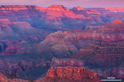
View from Mather Point, Grand Canyon National Park
Finally, there is one of the great wonders of the world - the Grand Canyon.  Grand Canyon National Park is divided into two sections - the South Rim and North Rim.  The South Rim is the popular side with easier access.  It two incorporates a shuttle service all but a couple months of the year, and it works quite well.

Mather Point is probably the most popular vantage in Grand Canyon National Park.  Nearby Yavapai Point is also very nice.  Both serve well for both sunrise and sunsets.

View from Mather Point, Grand Canyon National Park
Hopi Point is an excellent point to experience sunset on the South Rim - possibly the best in fact.  One can hike out to this point, then take the shuttle back after dark.

Yaki Point is best for sunrises and popular with photographers (along with Mather Point).  This requires an early rise and the use of the shuttle service.

The North Rim is at a substantially higher elevation.  The winter months bring road closures, which makes access difficult.

For the more ambitious, there are numerous hikes down into the canyon.  These are best planned well in advance as permits can be challenging to obtain.

There are many more places to visit.  I have only scratched the surface.  Many more images can be viewed in my Southwest Gallery.  You may also view images from many other areas at my website, www.mountainscenes.com.

I hope my images and the info I have shared spark a desire to visit one or more of any of these areas.  As I write this, I am only a week away from going back to some of these wonderful areas myself!  I hope you enjoy.  Thanks for visiting.


Sunday, February 11, 2018

Snowpatch Spire in the Bugaboos

Snowpatch Spire in late fall, Bugaboo Provincial Park, Purcell Range, British Columbia, Canada.
Snowpatch Spire, Bugaboo Provincial Park.
Snowpatch Spire is a prominent peak in the Bugaboos of the Purcell Mountains in eastern British Columbia, Canada.  It's named after the prominent snow patch on its shoulder.  As with many of its neighboring peaks, it's granite rock offers world-class mountaineering routes and attracts climbers from around the world.

Bugaboo Provincial Park is accessed from Highway 95 just north of Radium, BC.  This incredibly scenic park is very remote, offering very little in the way of hiking trail.  However, it offers two popular trails - Cobalt Lake and Conrad Kain Hut/Applebee Dome.

This image was taken on a late fall morning during a recent trip to the Bugaboos, and was currently licensed for worldwide usage in a soon-to-be-released book.

While I am still working on my Purcell Gallery and don't have it up yet, you may find other images to your liking on my website at www.mountainscenes.com, including images from the Canadian Rockies, right next door to the Bugaboos and Purcells!

As always, thanks for looking!