Wednesday, January 16, 2013

Gitzo GT2531 Tripod Fails


Formerly a Gitzo tripod, relegated to a monopod.
New Years Day was a glorious day in the Pacific Northwest.  A high pressure trough settled in above us, giving us bluebird skies and reason to get out and enjoy the day.

I spent the day at Mount Rainier National Park, snowshoeing up to Mazama Ridge and photographing the mountain above rolling mounds of snow and snow-covered trees.  It was a fantastic setting in fresh powder snow.

Then it happened.

My tripod sank into the snow with the weight of my 5D MII camera, as one would expect.  What I didn't expect was when I lifted it back out of the snow, again mostly powder, only two legs retracted from the snow.  The third remained in the snow, having broken off of the centerpiece.  There had been very little, if any, resistance when pulling the tripod out of the snow.  This was fresh snow.

Broken hinges on Gitzo tripod.
I was in dismay.  Close examination revealed that the hinge had broke.  The leg itself was still in fine condition.  I first thought that the hinge must have developed stress cracks over time and finally given way.

I was as puzzled as I was disappointed.  Fortunately I still had two legs left and could still compose pictures by sticking them in the snow, and then prop the third independent leg against the centerpiece for sturdiness.


Broken Gitzo GT2531 Mountaineer tripod.
Failed hinges on Gitzo tripod.
 Then it happened again!

Now I was in complete disbelief.  Again, no pressure applied to the legs or hinges to speak of.  Could it be the cold temps?  High for the day was forecast to be 32*F, and it was nearly noon.  I would guess temps were in the mid to upper 20s when the failures happened.

As disappointed as I am in the failure, I am equally puzzled as to why.  This is not the way I would expect a tripod to fail, especially with a trusted name like Gitzo.

I plan to get in touch with Gitzo to get their take on this failure.  I also have arranged for an independent analysis on the breaks for metal fatigue, stress signs, etc.  Why go to this length?  Because it's readily available to me at no cost.  It's just how I'm wired.

I have absolutely loved my Gitzo tripod.  It's the best tripod I have owned to date, this failure aside.

I hope to get valuable input from Gitzo.  Have they seen this before?  Is this an inherent problem with the leg hinge?  Is it a weakness of the material used? (though the centerpiece is of magnesium construction, the hinge bushing is clearly of different material).

I will keep you posted of my findings.  I also encourage anyone else who has experienced similar problems to comment, either publicly or privately.


Saturday, January 12, 2013

New Canadian Rockies Gallery!

The Ramparts reflected in Amethyst Lake in Tonquin Valley.
I'm excited to announce the addition of my new Canadian Rockies Gallery to my Mountain Scenes web site!  I hope you enjoy viewing these fresh, new images.

It's been a long and tedious process, from editing the thousands of RAW images to final SEO web preparation and layout.  In fact, I forgot just how much work such a task involved!

The images represent Banff National Park, Jasper National Park, Kootenay National Park, Yoho National Park, Mount Assiniboine Provincial Park and Mount Robson Provincial Park. 

Hikers below Mount Victoria on Plain of Six Glaciers trail.
Included are images of Mount Assiniboine, Lake Magog, Mount Robson, Berg Lake, Lake Louise, Moraine Lake, Mount Victoria, Mount Temple, Tonquin Valley, Amethyst Lakes, The Ramparts, Lake O'Hara, Opabin Plateau, Peyto Lake, Castle Mountain, Floe Lake and Rockwall, and more.

I've enjoyed many trips to the Canadian Rockies over the years.  I have enjoyed them while car camping with family, dayhiking, backpacking, climbing and even canoeing.  Each one of these activities offers a different perspective and experience.  I recommend them all.

I hope you enjoy these new images.  All images are available as prints, as well as for commercial use.  I believe they would make an excellent addition to your walls, electronic presentation, or publication. 

As always, I welcome your comments or questions.  If you are planning a trip yourself, feel free to drop me an e-mail with any questions.  I am always happy to help.

Thank you for visiting.

Wednesday, January 2, 2013

Happy New Year!

Mount Rainier from Mazama Ridge in winter.
A late Happy New Year wish to all!  Late because I spent the day at Mount Rainier taking images like this!

We enjoyed a wonderful snowshoe up Mazama Ridge from Paradise with bluebird skies above and excellent snow conditions.  It's days like this that make me really appreciate living in the Pacific Northwest.

How did you bring in the new year?

May 2013 bring you happiness, fulfillment, and success in all your endeavors.  Cheers!

Friday, December 28, 2012

Photographing Mount Assiniboine

Mount Assiniboine reflected in Lake Magog.
I can't think of a more iconic mountain for the Canadian Rockies than Mount Assiniboine, and I have learned in recent years just how world-renowned it is.  It is the 'Matterhorn of the Rockies'.  I have sold usage rights for my images of Assiniboine to calendars, books, magazines, and even product packaging.  The only mountain I have sold more images of is Mount Rainier.

This image of Mount Assiniboine reflected in the waters of Lake Magog in the early morning hours is appearing in a magazine in the Czech Republic.  It was taken several years ago during a multi-day backpack.  I had plans to revisit the area this past fall, but it didn't happen.

Mount Assiniboine is most commonly reached by a 17 mile hike up Bryant Creek and over Assiniboine Pass (with Wonder Pass a wonderful option on the return) or via helicopter on select days.  One can elect to stay in the lodge, the Naiset Huts or Lake Magog Campground.  More information can be found here.

September is a wonderful month to visit for photography as one can catch the larches turning color.  Excellent compositions can be had from the shore of Lake Magog (in front of the lodge).  If the water doesn't cooperate in catching the reflection of the peak, there is a tarn nearby that is more sheltered from the breeze and may serve you better.  Don't forget to hike up The Nub for a more encompassing view.  Also, be sure and check out Og Pass where you can frame the mountain above the larch.  Wonder Pass offers excellent photography as well and is a must visit, though Assiniboine will not be your subject matter here.  In all cases, morning offers the best light

The best lens selection for this area is a wide-angle.  As always, bring your polarizer and a selection of GND filters.

This image and more of the Canadian Rockies will be up on my website shortly.

Happy shooting!

Wednesday, December 26, 2012

Visit Rainier Brochure

2013 VisitRainier Brochure
 I'm pleased to share the 2013 Visit Rainier Brochure, which sports one of my images of Mount Rainier on its cover.  The image was taken from Spray Park during flower season, close to sunset.  Spray Park is one of my favorite destinations in the park.  Many times I have hiked up to these meadows in the late afternoon and photographed the flowers and sunset, then returned to my truck in the dark with headlamp.

There is so much to do at Mount Rainier throughout the year, whether you like to climb, hike, horseback ride, fish, car camp, ski, snowshoe, etc.  Local communities around the park offer additional ammenities to those in the park.

So where do you start your planning?

If you plan to visit Mount Rainier National Park, I highly recommend you visit the Visit Rainier web site.  It is the ultimate planning site for the park, offering recommendations for lodging, eating, recreation, maps, current road and trail conditions, web cams and more!  It really is an all-in-one site for planning.  Check them out!

The Visit Rainier brochure is available at most businesses around the park, and is free.  Pick one up!

Tuesday, December 11, 2012

Photographing Mount Robson


Evening light on Mount Robson.
Mount Robson is the tallest mountain in the Canadian Rockies at over 12, 972'.  It's a majestic mountain, especially when viewed towering above Berg Lake or from the Robson Glacier's lateral moraine below Snowbird Pass.  It attracts hikers, climbers and photographers from around the world, and it's easy to see why.

While Robson can be viewed from Highway 16 and the Visitor Center, the best views of the mountain are from the opposite side, requiring a 13 mile hike or helicopter ride (restricted to certain days) to Berg Lake.  From there, day trip options abound for more vantage points.
Evening light on Mount Robson.
While it is common to see people day hiking up to Berg Lake, it is better done as a multi-day backpack for photography.  The reason for multiple days is due to both the number of places to visit each morning and evening, as well as weather considerations.  Robson is notorious for bad weather,  or so I've been told.  I've been lucky in my trips I guess!

Kinney Lake is an easy 4.5 miles from the trailhead.  It offers excellent campsites with with tent pads, some right on the lake.  Kinney Lake holds a beautiful reflection of the surrounding peaks in the morning (and possibly evening).

Suspension bridge over Robson River.
From Kinney Lake the trail climbs over a rib, descends back down to cross the Robson River, and then switchbacks up to another crossing of the Robson River over a suspension bridge at Whitehorn Campground.  From here, views up the Valley of a Thousand Waterfalls present themselves.  There isn't much photography to be had here necessarily, but all that is about to change.

Whitehorn Campground is a popular stopover for hikers wishing to establish a base camp for day hikes to Berg Lake and other areas.

From Whitehorn Campground, the flat trail continues up the valley a short distance to another crossing of the Robson River and a dramatic view of White Falls.

On the other side, the trail begins its steep ascent to Berg Lake, passing views of Falls of the Pool, Emperor Falls, and numerous other waterfalls along the way.  You will need a strong telephoto lens to capture these.  Due to the steepness of the valley, shadows wreak havoc in mid-day sunshine.  Morning and evening finds them in shade.  Of course, slightly overcast days would be best for nice even lighting.

After climbing above Emperor Falls, the trail passes through Emperor Falls Campground before traversing a hillside along the river on its final approach to Berg Lake.  Marmot Campground at the beginning of Berg Lake is reached after crossing a series of creeks, courtesy the Hargreaves Glacier.  Photographers will want to continue on to Berg Lake Campground a mile further along the lake shore.
Berg Lake Campground is perfectly situated above the lake shore near the lake's north end and offers postcard scenery practically from your campsite.  You have arrived!

The Berg Glacier above Berg Lake.
The photography options here are numerous.  The classic composition is to simply walk down the shore and compose the mountain across the water, hopefully with icebergs floating in the water for some added interest and depth of field.  The icebergs are present all year long, but are more numerous in early to mid summer.

Mount Robson draws both morning and evening light, so you will want to spend time at both here with camera on tripod.  The amount of light is dependent on the time of year.  By fall, evening light just barely kisses the summit rock, turning only the very top brilliant pink.  Blink and you might miss it.  Morning offers more light.  Both times are attractive and worth your time.

Reflections can be had in the pools created by the braided streams on the lake shore in late season.  Early morning and late evening when the temps are cold are best.

Don't forget to bring your telephoto lens to isolate sections of the Berg Glacier across the lake.  The ice seracs provide beautiful texture, and compositions are endless.  For added drama, include floating icebergs in front of the glacier where it meets the water - you know, the chunks of ice your heard calving off the glacier all night while in your tent!

For larger views, grab your headlamp and hike a short ways up the Toboggan Falls trail to a bench - yes, as in park bench!  It is situated in a clearing offering unobstructed views of the mountain and lake.  You can tell everyone how you had to hang precariously over a ledge to get your shot.  I won't tell.  Honest.
The Toboggan Falls trail offers excellent opportunities to photograph many waterfalls and cascades if you find yourself clouded in.

The Robson Glacier from Mumm Basin.
For even larger and more expansive views, hike up to Robson Pass (short, flat hike from Berg Lake) and follow the trail through the Robson Campground. This trail climbs steeply from the campground up to the incredibly scenic Mumm Basin. At a large cairn on the edge of a ridge, enjoy views down to Berg Lake, across to Mount Robson and the new view up the Robson Glacier towards Snowbird Pass, unseen from Berg Lake. From Mumm Basin, you can traverse south to the Toboggan Falls for your descent back to camp, or you can continue on to Hargreaves Lake for a longer loop back.

 
Mount Robson and the Robson Glacier.

 If I could recommend one hike from Berg Lake, it would be to Snowbird Pass.  It's not for everyone though.  It's an extremely strenuous hike with many exposed sections of trail. Oh, but the rewards!  As you climb the steep moraine, the Robson Glacier rests at your feet.  Soon the beautiful glacier bowl of Robson is revealed - a world of rock and ice.  The best view is at the very top of the moraine, though you won't be convinced of this until you get there!


Mount Robson from Snowbird Pass.
From the top of the moraine, the trail climbs up to a beautiful hanging basin of tarns, streams and meadows.  The rolling meadows seem to stretch on forever.  Snowbird Pass can be seen up ahead and it seems so close.  But every time you think you are almost there, you come over a rise and realise there are more meadows to traverse and streams to cross!  Finally, the trail reaches a rock slope where it is defined simply by cairns, and the final climb commences - up to some of the best views in all the Rockies.

Look over your shoulder back to Mount Robson and the Robson Glacier (I mean, its not like you could ever get tired of looking at it).  Ahead at Snowbird Pass proper, find a spot to shed your pack and be amazed.  Ahead of you to the north is the expanse of the Reef Icefield and Coleman Glacier in Jasper National Park.


The Reef Icefield and Coleman Glacier from Snowbird Pass.


The Reef Icefield is huge, encompassing miles of ice.  Goat trails abound, and the animals can often be seen on the glacier (or maybe above you on the rock).  You're in a different world now, one that is hard to peel yourself away from on a nice sunny day.  Enjoy it and don't forget to bring the memories back on your camera card.
Dramatic clouds at sunset over Berg Lake.
I think all lenses come in handy here.  I used my 17-40mm lens to capture the above reflection shot of Robson in the pool of water.  I also used wide angle to capture most of the Robson images above Berg Lake, and the pano from Snowbird Pass.  The trusted and true 24-70mm was a workhorse as well, also used at Berg Lake, on the Toboggan Falls trail and Mumm Basin.  Finally, I hauled my 70-200mm and 2x teleconverter up for wildlife opportunities and the chance to zoom in tight on the glacier.  Of course, there is a huge weight consideration with this last one, and many may elect to leave it at home.  Cost vs reward is a viable argument!

The standard line of filters are recommended for this trip - polarizer and both 2 and 3-stop GND filters.  I always like to carry an enhancing filter as well.

If you are considering visiting during the summer months, I recommend you consider reserving a permit.  Changes have been made for 2013, and reservations will start being accepted January 2nd.  More information here.  If you plan to visit during the fall, reservations are not necessary.  When I visited in mid-September with a bluebird forecast, Berg Lake Campground was 1/2 full at most, Whitehorn, Rearguard and Marmot had just a few residents, and Kinney Lake was empty.

I hope you get the chance to visit this wonderful place.  I would budget 4 days minum in favorable weather, more if questionable weather is forecast.  Unless you elect to fly in via helicopter, it's a long haul in with most of the elevation gain at the very end.  Stay a while.  Enjoy it.  You earned it.
 
I hope to have these images and more up on my website very soon.  Thanks for visiting.

Thursday, December 6, 2012

Mount Assiniboine Image Usage

Mount Assiniboine above larches in fall.
I can't believe it has been exactly 1 month since I last posted here.  See, I told you things were busy!

Some of what has kept me busy has been the editing of images from multiple visits to the Canadian Rockies.  In July I spent considerable time around Lake Louise and along the Icefields Parkway in Banff National Park.

In late September I returned for backpacks to Berg Lake, Tonquin Valley, Floe Lake, and a visit to the Lake O'Hara area (I will be posting about these trips soon!).

Lake Magog in Assiniboine Provincial Park was to be my final backpack of this trip, but it did not happen.  The image above of Mount Assiniboine was taken during a previous visit.  This image was recently licensed for use in a retail book in Japan, appearing in a print run of 50K, and has been a popular image for me over the years.

I will be introducing a new Canadian Rockies gallery on my web site soon, which will include this image.  I know, I've said this before, but this time it is really going to happen!  Stay tuned...

Tuesday, November 6, 2012

No More Shows or Appearances in 2012

I've received several inquiries about upcoming appearances for the remainder of 2012.  I'm sorry to say that due to my extremely busy schedule, I have had to cancel regularly scheduled appearances and pass on some new invites.  It's a tough decision as I really love doing these shows and meeting people.  I hope to resume doing shows in the spring of 2013.

I'll keep you posted as my schedule becomes available.

Tuesday, October 9, 2012

Western Byways - Wyoming Edition

I'm currently editing images from my recent trip to the Canadian Rockies.  Hopefully I will be able to share soon!

In the meantime, I realize I haven't shared any recent published work.  Let's change that with this current cover image for Western Byways - Wyoming Edition.

This image is of Elephant Head reflected in a small tarn near Island Lake.  I'm not sure I would have captured this image had an unfortunate event not altered our trip.

We were only about 2 miles up the trail when I turned my ankle and crumpled to the ground in pain. I couldn't seem to walk it off, and the pain grew worse as I rested. In my mind, we had traveled too far (from Washington) to turn back. We still had 8 more miles to hike to get to Island Lake - our desired camp.

Eventually, with the help of trekking poles, I was able to force some weight onto the ankle and get back on it. We continued up the trail at a snail's pace, probably 1/3 of my normal hiking speed. I found myself focusing on stepping squarely each step; a tedious and disconcerting process.

We successfully arrived at Island Lake late in the day and found a nice campsite. It would be our home for the next few days.

With the ankle injury, there would be no wanderings into Upper Titcomb Basin or Indian Basin on this trip, as originally planned. I had explored both areas on a previous trip and desperately wanted to return for photography. Instead, I focused my photography around Island Lake in mornings and evenings, which offered some benefits and new learning experiences.

What did I do during the middle of the day? Mostly rest and soak my ankle. After all, I had 10 miles of hiking ahead of me to get back to my truck!

We still enjoyed our trip immensely. How could we not with such beauty all around us? After all, we were in the Winds! We experienced beautiful sunrises and sunsets, afternoon lightning storms, and beautiful rainbows.

More images from this trip and others in the Wind River range can be viewed in my Wind River Gallery.

Wednesday, October 3, 2012

Back from the Canadian Rockies

Grizzly print on vehicle window.
I'm back from the Canadian Rockies with many stories and experiences to share!  I visited Berg Lake, Mumm Basin and Snowbird Pass in Robson Provincial Park, Tonquin Valley and Macarrib Pass in Jasper National Park, Floe Lake, Numa Pass and Numa Peak in Kootenay National Park, and Lake O'Hara and Opabin Plateau in Yoho National Park.

I logged over 100 miles of hiking, and just over 19,000' elevation gain during my visit.  I met lots of great people, including Mike from Beacon Hill in Seattle, Mike Vincent of Canmore - a professional guide for Chateau Lake Louise, Don & Wendy from Virginia, Scott Forsyth - a professional photographer from Calgary, and more.

I had hoped to see a lot of wildlife (on my terms, of course), but this didn't really happen.  A grizzly bear had recently been spotted near Berg Lake before my visit, but there were no further sightings.  A sow grizzly and her two cubs had been hanging around Macarrib Pass, but I only saw old scat both times I hiked through this area.  A lone caribou was spotted at Amethyst Lake during my visit, but I missed it.  Wolves were present throughout the Tonquin Valley, but I did not actually see them.

Oh, but I do have some wildlife stories to share!

I'll start with my overnight stay at the Portal Creek trailhead in preparation for my hike into the Tonquin Valley.  As I pulled into the parking lot in early evening I saw two porcupines wandering about.  Later that night I could hear them (and likely rodents) beneath my vehicle.  At ~ 1:30 am I was awakened with a loud thud against my vehicle.  I sat straight up, startled.  Was someone trying to break into my vehicle?  The noise was much too loud to have been caused by the porcupines.  I listened further, expecting to hear someone test my door handles.  Nothing.  No cars had pulled into the parking lot.  I eventually used my key remote to turn all lights on my vehicle on - interior and exterior.  Nothing further was heard.

I couldn't fall back asleep right away because I had to pee.  So I got out of my vehicle and walked only a couple of steps to do so.  I returned to to my vehicle and, eventually, was able to go back to sleep - though the mystery of the sound continued to baffle me.

I rolled over at 7:30 in the morning and looked out the window to see how light it was outside.  It was then that the source of the thud was answered.  Just above my head on the rear side window was a distinct paw print from a grizzly bear, with other smudged prints and scratches below!

Soon a couple of guys showed up, including one from Fire and Rescue.  Neither had seen or heard of such a thing.  Both encouraged me to report the incident to Bear Management.  The gentlemen from Fire and Rescue then asked my permission to report the incident himself, since he had a buddy working for Bear Management.

I began getting my pack ready for my trek.  As I walked around to the other side of my vehicle, I noticed a huge wet spot in the parking lot.  It became clear that the bear had been on this side of my vehicle relieving itself at the same time I was doing so on the other side!

I returned from my trip to find a note on my windshield, asking me to stop by the Information Centre in Jasper to discuss my bear encounter, and did so.

Wolf print near tent at Amethyst Lake in Tonquin Valley.
While camped at Amethyst Lake in the Tonquin Valley, I spent time both nights photographing the stars.  On my second night, I awoke at 1:30 am and ventured a short distance from the tent.  As I photographed, I occasionally could hear something in the trees behind me.  Every now and then I would shine my headlamp over in that direction, but never saw anything. 

At 3:15 I finally packed it in and returned to my tent.  I no sooner got settled into my sleeping bag when I heard something outside my tent.  It broke branches on the back side of my tent, then circled the tent.  It returned to the back side and pawed or bumped my tent.

I sat up, cleared my voice rather loudly, and turned my headlamp on to illuminate my tent.  I soon heard twigs breaking in the distance as whatever animal had been visiting me retreated off into the night.  The next morning I awoke to wolf prints around my tent!

Also while photographing stars my second night, a large bird dove down upon me, pulling up only several feet above my head.  Its wing span was huge and I realized instantly that it must have been an owl.  Its angle suggested it was actually interested in my camera and tripod, which I was obviously standing close to.  Needless to say, it startled me!  I never heard it.  I only saw it out of the corner of my eye as it was only feet above my head.  Those poor rodents at Amethyst don't stand a chance with such a stealth predator in the air!

So, those are my wildlife stories.  The griz experience was pretty scary at the time, mostly due to the mystery.  The wolf experience was scary due to the fact that I assumed it was a cat.  It wasn't until the next day while sharing the story that it was pointed out to me that cats walk with their claws retracted, leaving only pad marks.  The tracks around my tent had distinct claw marks, making them canine.  I assumed they were cat mostly due to their size - they were huge.  I had no idea wolves had such large feet.  Knowing I had a curious wolf follow me back to camp was more comforting to me than to think I had a cat stalking me in the night!

I hope to begin editing images from my trip soon.  Stay tuned!

Thursday, September 13, 2012

Photography Trip to Banff National Park


Ten Peaks above Moraine Lake, Banff National
Park.
The Canadian Rockies are comprised of four adjacent National Parks - Banff, Jasper, Kootenay, and Yoho - and a distant Waterton.  They also include several provincial parks, including Assiniboine, Hanber and Robson.  They are heaven north of the border and one of my all-time favorite destinations - one of Canada's true treasures.

Of all the parks, Banff is probably the most popular.  It offers a wide variety of attractions and photography possibilities; whether it's nature landscapes, manicured parks, man-made structures, people & wildlife,  or a combination of all the above.

I recently returned to this park after a lengthy hiatus and spent a week photographing throughout the park, even venturing into Yoho for a day.

It was a fantastic trip with mostly great weather.  It included summiting a 9,000' peak with my 9-year old daughter, several family hikes, lots of wildlife (including a grizzly bear near our campground) and photographing most of the major attractions of the park.

The peaks around Lake Louise reflected in Herbert Lake.
The most popular area in Banff National Park outside of the Banff town site is the Lake Louise vicinity.  Lake Louise and nearby Moraine Lake draw visitors by the thousands every day, and for good reason; the scenery is outstanding and both offer excellent hiking trails.  Parking can get crazy by late morning at both.

Mount Victoria, Mount Lefroy, Temple Peak and The Ten Peaks offer dramatic settings in the area, whether it is hiking to their base, climbing to their summits, or catching their reflection in a lake.

One of the beauties of this area for photographers, besides the scenery, is that the best time to photograph the area is in the early morning. So it is easy to beat the crowds. Arriving at both Moraine Lake and Lake Louise in the early dawn hours found me nearly alone as early light struck the nearby peaks.

The humorous thing I found about Lake Louise was that both mornings I spent photographing there was that the masses would show up just about the time I was packing up to leave. Visitors from the lodge came running down to the shore, often in their pajamas and bathrobes, and the tourist buses would start arriving in the parking lot.

Moraine Lake never produced such crowds during my visit.  Typically I would see a couple of other photographers during the prime light (arriving after me), and a few more would arrive before I packed up.  Returning mid-morning would find larger numbers, but nothing crazy.  The crazy numbers are found mid-day!


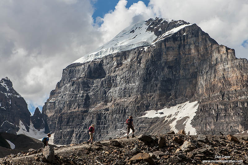
Hikers below Mount Victoria on the Plain of Six Glaciers
Trail.
 There are plenty of hikes to do in the area once you are finished capturing first light.  From Lake Louise, the Plain of Six Glaciers trail follows its north shore and climbs well above the lake to a prominent viewpoint of Mount Victoria.  There's even a tea house waiting for you near the end!

Another fun trail is to Saddleback on the opposite side of the lake.  The adventurous can scramble the final 1,500' to the summit of Fairview Mountain.

Paradise Valley is another popular destination, though bears can be a problem.  Such a warning was in place during our visit, requiring a group size of four or more.

Mount Temple above the Bow River.
Moraine Lake offers one of the best hikes in the area, especially in larch season (late September).  Larch Valley and Sentinel Pass are excellent destinations.  Again, group size restrictions can be in order due to bear activity, and were during our visit.

The Lake Louise Campground makes for an excellent base camp.  It is very close to both Lake Louise and Moraine Lake for easy and quick access, and is also centrally located to attractions further away.  The campground is alongside the Bow River, which affords excellent views of Mount Temple.  It is also located in prime grizzly bear habitat, necessitating an electric fence around it (it's not as obtrusive as it might sound).  The proof was in the pudding during our visit, as I returned to camp one morning to spot a mother grizzly grazing in an adjacent meadow.  As I later learned, she had two cubs.  I was not fortunate enough to see them.

I spent many evenings driving the Bow Valley Parkway between Lake Louise Village and Castle Mountain Junction.  This is probably one the best wildlife viewing areas in the park.  I photographed numerous black bears, bull elk, and the largest osprey nest I've ever seen, complete with young!


Castle Mountain above the Bow River.
 Of course, there is also Castle Mountain, which received pretty dramatic light most every evening as afternoon thunder storms cleared.  Most people seemed oblivious to this though as they were too occupied driving up and down the parkway in hopes of seeing a bear.

Near Castle Junction, several very large bull elk made daily appearances.  They were most likely to be seen in the evening, but not limited to.  They were quite a treat to see.


Peyto Lake along the Icefields Parkway.
The drive up the Icefields Parkway is not to be missed.  There are photography options every stretch of the way.  An entire day or more can easily be spent along this highway, especially if continuing all the way Jasper.

Peyto Lake is an often photographed lake along the parkway.  It requires a short but rather steep hike to the famous viewpoint, and you will not be alone at mid-day, which is considered the best time to photograph it.  I actually didn't have much luck at mid-day due to overcast skies and flat light.  The image here was taken in early morning as a storm crept in.

Bow Peak above Bow Lake along the Icefields Parkway.
 I was fortunate to time my visit during flower season, and was amazed at the flower show along the Icefields Parkway.  They lined the road as far as I ventured, and offered unlimited photography opportunities.  My favorite area was around Bow Lake.

On a day that cloudy skies and showers were forecast, we headed over to Yoho National Park and visited Takakkaw Falls.  Though Banff was mostly cloudy, Yoho offered us bluebird skies and pleasant hiking to the base of the falls.

Takakkaw Falls.
As I write this, I am packing and preparing for a return trip to the Canadian Rockies - leaving in just a couple of days.  This time, I will be spending two full weeks in the backcountry of Robson Provincial Park, Jasper National Park, Yoho National Park, Kootenay National Park and Assiniboine Provincial Park. 

Backpacking destinations will include Berg Lake (Robson), Tonquin Valley (Jasper), Floe Lake and the Rock Wall (Kootenay), Lake O'hara (Yoho) and Lake Maggog (Assiniboine). All but Tonquin Valley will be repeat visits for me.  My itinerary has me hiking 136 miles (not including side trips) with just under 10,000' gain during this time.

Upon my return I hope to have a lot of images to edit!  I also hope to edit my wildlife images from my previous trip, and to construct a new Canadian Rockies gallery on my web site.

Wish me luck!


Friday, August 31, 2012

Recent Photography Trip to Mount Rainier National Park

Mount Rainier above Edith Creek before sunrise.
Many influences come into play when photographing outdoors.  Many of them, such as choosing location, camera settings, lens and filter selection, and composition, we control.  But there are natural elements that we do not.  Oh, we plan ahead and do our research so as to put ourselves in the best possible position to be successful, but we don't control it.  For me, this is one of the most exciting elements of photography

Recently I met up with my good friend Kevin Ebi at Mount Rainier National Park.  I had spent the previous morning there and had scouted out the flowers around Edith Creek - our meeting point.

Arriving in time for sunrise requires a very early start and involves driving in the dark to your destination.  You can't wake up to a bluebird sky and say to yourself, "Yes, I think it will be a good day to go photograph."

I knew the forecast called for a change in weather towards afternoon on this day, but noticed as I neared the Nisqually Entrance that the stars were blurred.  This told me there was moisture in the air.  I knew this could mean low elevation fog, which got me even more excited!

As I drove up the Paradise Road, I noticed a definite cloud bank to the west and no stars.  As I neared the Paradise parking lot, it became clear that a system was moving in quicker than I had expected.  Yet, to the east it remained mostly clear, but with some interesting whispy clouds.  Of course, east is what is important for sunrise photography!

A lenticular cloud over Mount Rainier at sunrise.
Kevin informed me that the forecast had changed somewhat, and they were calling for completely cloudy skies by 7:00 am.  All we could do was cross our fingers.  This could still work.

We set our cameras up in the dark and aimed them at the mountain.  We watched the sky in between shutter clicks (yes, we start taking pictures well before first light on the mountain).  We watched the cloud bank to the west growing stronger and more clouds appearing to the east, though still generally scattered.  This morning had the opportunity to prove dramatic and exciting, or it could skunk us all together.  We remained optimistic.

Clouds began to form directly over the summit of Rainier and grew in size as they moved west to east.  Soon they turned a brilliant pink and it was game on!  As we watched the intensity grow above the mountain, we noticed signs of a lenticular cloud forming above the mountain.  It grew to prominent status rather quickly, just in time for the first rays of the sun.  We had found paradise! (pun intentional).

As climbers and many others know, lenticular clouds are strong indicators of a couple of things:  They are a sign of heavy winds on the summit (often exceeding 100 mph), and a sign of a pending weather system arriving in the next 24 hours.  This meant there were plenty of unknowns ahead of us as the mystery unfolded on this morning.

Lenticular cloud over Mount Rainier at sunrise.
The lenticular cloud became more and more defined, and the unique light seemed to last an exaggerated length of time - minutes, not seconds.

Alas, all good things must come to and end and this experience was no different.  As the sun rose higher in the sky the light became much less dramatic, then disappeared entirely as clouds began to consume the skies above and the wind picked up.

As Kevin and I began packing our gear up, we could only smile, knowing we had been a part of something special.  Neither one of us had actually photographed a lenticular over the mountain before, and neither one of us could have predicted it would happen on this morning.  But we were ready for it and embraced it when it happened.

From Paradise, I drove around the mountain to the Chinook Pass area to hike the Naches Peak Loop.  I had heard rave reports of the flower show and wanted to scout the area out for a possible return the following day.  Despite not planning to do any photography, I carried my camera gear anyway.  I was glad I did.

Flowers of lupine and assorted flower along the Naches Peak Loop.
The flower show was incredible from the moment I hit the trail and grew stronger the further I hiked.  Upon crossing the shoulder of Naches Peak beyond the PCT and Dewey Lake junction, I was greeted by the spectacular meadows above the tarn and some interesting light on both the meadows and the mountain.  I wouldn't ordinarily shoot so late in the day (10:00ish), but the diffused light struck me.  The soft transition of Rainier into clouds also piqued my interest.  It was a unique blend.

Shortly after working this composition, the sun became much stronger and subtleties of the setting that struck me were gone.  But I was glad to not have left my camera behind in the name of a scouting trip!

These images and more can be seen in my Mount Rainier Gallery.  As always, thanks for visiting!