My first visit to
Saguaro National Park and surrounding areas was a much different experience for this Pacific Northwesterner, whose only previous experiences were that of Utah and northern Arizona. Needless to say, the cactuses are much smaller and different species in those regions.
Saguaro National Park is actually divided into two sections - east and west, divided by the city of Tucson. I had never seen such a thing.
Our first outing was a trek up Sabino Canyon on what started as a rather cool and breezy day. It was pleasant but crowded. There is a parking fee that can be paid in cash, check or over your phone to their website. Cell phone service is hit and miss though, and I paid for parking three times for my single visit because after hitting the submit button my browser just kept spinning and never sent me to the payment received page. I returned to the hotel to find three email acknowledgements in my inbox!
I would recommend arriving early to beat the crowds and the heat. Definitely bring lots of water. While our hike started out cool and breezy, it quickly warmed up as we climbed up the canyon.
The next day I set out on a loop hike up to Wasson Peak, ascending King Canyon Wash Trail to the King Canyon Trail and finishing on the Norris Trail to the summit. It was a very windy day, especially at or near the passes and ridgetops, and the strong breeze was cold when the sun went behind the clouds. The views were amazing though and the few people I encountered were very friendly.
I spent as much time as I could stand on the windy summit before descending down the Norris trail back to the junction, then continued thru the notch and down an incredibly scenic stretch to catch the Sendero Esperanza Trail, which cuts back over to the King Canyon Trail Wash Trail. However, instead of following it all the way back, I finished my descent by taking the Gould Mine Trail back down to the road and parking lot. Glad I did! What a fun hike! I definitely recommend it and will do it again myself, hopefully on a warmer day.
While I did take my camera gear with me on this hike, it never came out due to the flatness of light in often overcast skies. Lots of phone pics though!
The next evening, I returned to this area to photograph sunset from an overlook I scouted the previous day - Gates Pass Overlook. This overlook, besides providing nice compositions of Saguaro cactuses in the evening light, also offers an incredible vista to the west to watch the setting sun. As it turns out, it also attracts a crazy amount of people at sunset, some of whom began double-parking and blocking people in rather than parking in the overload parking lot across the highway (a minute walk).
We didn't get to witness much cloud action on this night. Those that were present in the evening disappeared before sunset. Still, I was surprised to catch some red in the sky as the last of the sun vanished behind the distant ridge.
The next day began my photography trips to Saguaro National Park proper after having scouted them the day before. I started my morning in Saguaro East, closest to the hotel and the better morning location, in my opinion.
The Cactus Forest Loop Drive in Saguaro East in a must drive! It's a paved road that is mostly one-way thru ever-changing scenery as the elevation changes. The Rincon Mountains serve as a wonderful backdrop thru most of the drive. There are also many trails to explore.
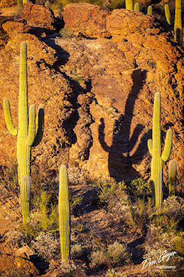
That evening I returned to Saguaro West for sunset, driving the gravel/dirt Hohokam Road to The Valley View Overlook trail. A quick hike up to the ridge scored me the silhouetted cactus image at the top of the page, and a pleasant walk out in the dark.
The next day was departure day to catch our flight home. But I awoke to witness the most dramatic light I had experienced the entire trip! I quickly set my camera and tripod up on the hotel balcony and began shooting away! A storm had rolled in overnight, offering rain throughout. But as the morning sun rose, some of its rays would sneak thru the dark clouds for a couple of moments before fading away. My experience has been that such an occurrence is usually short-lived. However, this went on for a couple of hours, making packing difficult! Slowly, the sun began to win battle and it was off to the airport.
As always, thanks for looking!


