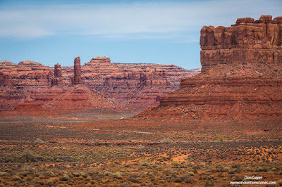
Tucked away in the far southeast corner of Utah is the very scenic and remote Valley of the Gods. This scenic gem is very similar to nearby Monument Valley, but on a smaller scale and without all the strict tribal regulations and commercialism. It offers isolated buttes, towering pinnacles and wide open spaces for wandering and exploring.
Located off Highways 163 and 261, the nearest town is Mexican Hat, population 31 (as of 2010), offering a 7/11 gas station as its only service.
Valley of the Gods was formerly part of Bears Ears National Monument, but lost that status in 2017 with the changing of the monument's boundaries. It now resides on BLM land. There are no official trails or campgrounds, but both hiking and private camping are very much available.
A 17-mile dirt and gravel road (FR 242) winds through the valley, stemming between Highways 163 and 261. It's a relatively well-groomed road, but does have some bumpy and steep sections. In dry conditions the road is easily travelled by regular vehicles. But after heavy rains, a 4x4 might be necessary.
The valley is home to such landmarks as Lady in the Bathtub (Balanced Rock), Rudolph and Santa Claus, Castle Butte, Battleship Rock, Setting Hen Butte, Rooster Butte, Seven Sailors and more. It doesn't take much imagination to see the resemblance of each formation to their name. Conveniently, FR 242 winds amongst them and offers great access to up-close viewing points.
The red sandstone rock in the valley is extremely photogenic and turns a brilliant red at sunset. Mornings can be quite nice as well.
The valley can be entered at two locations. If driving from the east on Highway 163, the entrance is an easily missed turnout to the right with a small "Valley of the Gods" forest service sign.
If arriving from the north via Highway 261 at the base of the spectacular Moki Dugway, the entrance is much more obvious with a large pull-out, bulletin board and entrance sign, and a bed and breakfast shortly up the road.
If arriving in the morning, I would recommend starting at the east entrance. In the afternoon, the west entrance would be the better choice. This puts the sun to your back rather than looking straight into it.
There are numerous pullouts along the road for extended viewing and photography opportunities, as well as camping. Surprisingly, you will find mostly solitude along this road. This valley offers a much more peaceful setting than its more famous neighbor 30 miles to the south - Monument Valley.
Photo Advise: You can probably leave the wide-angle lens at home for this one. Much more useful will be your standard and telephoto lenses.
While the entire stretch of road is quite scenic, I found the northern section of the valley to be my favorite. With campsite pullouts all along the road, it is easy to scout out desirable photography locations and then find a place to camp very near by.
This would likely be a prime destination for night photography as well. Unfortunately, I had cloudy skies at night during my short visit - another reason for a return trip!
Keep in mind that you must be totally self-sufficient photography wise when visiting this area. If you forget to bring something, it is a long drive to find photography supplies.
Finally, this can be a dusty area and you will want to protect your camera gear accordingly.
When you are ready for a change of pace, there are plenty of other options available nearby. For starters, I highly recommend turning right on Highway 261 at the west entrance and driving up the Moki Dugeway. This highway switchbacks up the cliff face 1,100' to the top of Cedar Mesa! It's a slow traveling gravel road, with 3 miles of hairpin turns. From the top you have a spectacular birds-eye view of Valley of the Gods and Monument Valley further off in the distance. There's not much for photography here, but the views are must see!
Monument Valley is about 30 miles to the south with incredible monoliths that vastly outshine those of Valley of the Gods. Unfortunately, with it come large crowds, strict regulations, and commercialism around every bend with roadside trinket stands, commercial photo offerings, etc. While the scenery was spectacular, I found it a hard pill to swallow after enjoying the serenity of Valley of the Gods. I would recommend visiting here first if you choose to do so.
 |
| The San Juan River meanders through Goosenecks State Park. |
 |
| Panorama of the San Juan River from Goosenecks State Park. |
You can see more of my images from Utah and the southwest in my Southwest Gallery. As always, thanks for looking!


