 |
| Mesa Arch, Canyonlands National Park |
I have
FINALLY finished updating my
Southwest Gallery on my website. I'm proud to say it is finally up-to-date, and includes images from all my visits to national parks, state parks, national monuments and recreation areas.
I've enjoyed several trips to the southwest over the years, yet I just can't get enough of the area. While I have visited most of southern Utah and some of Arizona, I still have so much more to see (and will be very soon).
Here are some of my favorites.
 |
| Soda Springs Basin, Canyonlands National Park |
Canyonlands National Park near Moab, UT is a fantastic park to visit, and much less crowded than its neighbor to the north, Arches National Park. It is comprised of three districts - Island in the Sky, The Needles and The Maze.
Island in the Sky is by far the most popular and accessible. It provides access to Mesa Arch (pictured above), Grandview Point, White Rim Overlook, Green River Overlook, Murphy Point and more. These are all accessible by car or short walks.
Don't forget to visit Dead Horse State Park while in the area. It is reached via a spur road just before the Island in the Sky entrance, and offers amazing views that will rival anything in Canyonlands!
 |
| Gooseneck, Dead Horse State Park. |
The Needles District can be accessed by car, but its best offerings are from the trail, including a hike into Chesler Park.
The Maze is 4X4 or mountain bike country and is visited much less.
Practically across the highway from the Island in the Sky district of Canyonlands is Arches National Park. There are many things to see along the road into the park, starting with Park Avenue and the Courthouse Towers. These require a short hike to be fully enjoyed, though it is quite easy (and can be made a one-way hike, all downhill, with a second vehicle).
 |
| Delicate Arch, Arches National Park |
Next up is Balanced Rock is just off the road a little further, and can be enjoyed from a picnic area.
Delicate Arch, the state icon, can be reached by a 3 mile trail to the fantastic viewpoint. Be prepared for the crowds, but understand the area is large and accommodating.
Fiery Furnace is a maze of confusing narrow canyons. Ranger led tours through this labyrinth are recommended, at least for your first visit.
 |
| Balanced Rock, Arches National Park |
At the end of the road is the trailhead to The Devil's Garden. This trail accesses Landscape Arch, Navajo Arch, Double O Arch, and many more.
5 miles east of Escalante, UT is Hole in the Rock Road. This is the main access to Grand Staircase - Escalante National Monument. There are several popular slot canyons to hike along the road, and also sports its own Devil's Garden (not to be confused with Arches). The first 12 miles of this road are suitable for cars, as long as weather conditions are nice.
 |
| Calf Creek Falls, Grand Staircase - Escalante NM |
Also near the town of Escalante is a short hike to a wonderful waterfall, Calf Creek Falls. This waterfall has a beautiful pool at its base, making the hike quite popular on a hot day. It also sports a fair amount of poison ivy, which I have yet to be successful in avoiding!
Scenic Byway 12 is an incredibly scenic road that connects Escalante and Boulder, UT. This section passes through some of the most incredible scenery Utah has to offer and always ranks among the top scenic drives in America. It's not to be missed!
Bryce Canyon National Park is beloved by most all. It offers easy access to prominent overlooks along its rim, and excellent hikes down into the canyon that add to the experience for those wanting more.
Sunrise and Sunset Viewpoints are easily accessed from the parking lot. Sunset Point is probably the best spot to view Bryce Canyon - and is also the most popular. A little further south is Inspiration Point, which requires about a twenty minute walk.
 |
| The Cathedral, Bryce Canyon National Park |
To really experience Bryce Canyon, I highly recommend descending down into the amphitheater and wander amongst the hoodoos. Two popular trails to do so on are the Queen's Garden Trail and the Navajo Trail. You can connect these two trails for an even better experience, and enjoy the sights of Thor's Hammer, Wall Street and The Queens Garden in one enjoyable stroll!
Fairyland Viewpoint, Yovmipai Point and Rainbow Point are also nice visits, though much different.
The light on the hoodoos changes drastically throughout the day. This place should be experienced in both early morning and late afternoon to see it at its best.
Oh, and don't forget to visit Red Canyon just outside Bryce NP!
 |
| The Temple of Sinawava, Zion National Park |
Zion National Park is a much different park than those already discussed. It basically consists of two areas - the canyon and the plateau. The plateau is easily viewed by car and incredibly scenic, especially around Checkerboard Mesa.
The canyon is also extremely scenic, but lends itself more to hiking. It can be zoo at times. It has a mandatory shuttle service to get you to the end of the canyon, and the Visitor Center's parking area to catch this shuttle is usually full by mid-morning during peak season. That being said, the shuttle system is the best I have experienced and could be modeled after.
Admittedly, I have a lot left to do at Zion. The popular attractions on foot are Angel's Landing, The Subway, and The Virgin Narrows.
Sights to see from the road are Towers of the Virgin from the Visitor Center parking lot and The Temple of Sinawava at the end of the road.
 |
| Lake Powell, Glen Canyon Recreation Area |
The Glen Canyon Recreation Area in Arizona is an incredible place to visit, and offers something for everyone. Lake Powell is a man-made lake (still the subject of controversy) and an excellent place to base camp. Nearby are numerous slot canyons and hikes, enough to spend days exploring. There are scenic road tours as well. Nearby are such attractions as The Wave (good luck getting permits!), The White Pocket, Cathedral Wash, Horseshoe Bend, Antelope Canyon, Glen Canyon Dam and more.
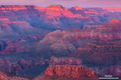 |
| View from Mather Point, Grand Canyon National Park |
Finally, there is one of the great wonders of the world - the Grand Canyon. Grand Canyon National Park is divided into two sections - the South Rim and North Rim. The South Rim is the popular side with easier access. It two incorporates a shuttle service all but a couple months of the year, and it works quite well.
Mather Point is probably the most popular vantage in Grand Canyon National Park. Nearby Yavapai Point is also very nice. Both serve well for both sunrise and sunsets.
 |
| View from Mather Point, Grand Canyon National Park |
Hopi Point is an excellent point to experience sunset on the South Rim - possibly the best in fact. One can hike out to this point, then take the shuttle back after dark.
Yaki Point is best for sunrises and popular with photographers (along with Mather Point). This requires an early rise and the use of the shuttle service.
The North Rim is at a substantially higher elevation. The winter months bring road closures, which makes access difficult.
For the more ambitious, there are numerous hikes down into the canyon. These are best planned well in advance as permits can be challenging to obtain.
There are many more places to visit. I have only scratched the surface. Many more images can be viewed in my
Southwest Gallery. You may also view images from many other areas at my website,
www.mountainscenes.com.
I hope my images and the info I have shared spark a desire to visit one or more of any of these areas. As I write this, I am only a week away from going back to some of these wonderful areas myself! I hope you enjoy. Thanks for visiting.


