Monday, July 5, 2010

New Web Site!

I'm excited to announce that I have gone LIVE with my new web site! Yes, the address is the same; only the presentation has changed!

This has been a taxing project because it has involved more than just a redesign. This is a brand new web site, built from the ground up. I say the ground up, because I went back and diligently worked with each image, using newer photo editing software and technique for web presentation.

It's still a work in progress; I have many out-of-state galleries to complete yet, and will do so soon. Check back often!

I hope you enjoy this new representation of my work.

www.mountainscenes.com

Thursday, July 1, 2010

Busy, Busy, Busy!

June was a slow month of blog updates for me. I have multiple projects I've been wrapped up in, and had actually hoped to have announcements out by now for for two of the bigger ones. I also still have all my Death Valley images from early April to edit and share, with my Glacier National Park trip just a few weeks away! No stress here!

My first project has been an update of my web site. Well, update is not accurate. It's a brand new web site. It's been a bigger project than originally planned as I realized I wanted to slim down the content, and re-edit my images using more current software and digital darkroom technique. I am also being much more thorough with my SEO on each individual page and image. It's been a lot of work, but I think it will be worth it.

My second major project isn't quite ready for sharing yet - sorry. You'll just have to stay tuned!

Saturday, June 19, 2010

A Fun Day at Mount St. Helens

Last Sunday I spent a wonderful time with my daughter down at Mount St. Helens National Volcanic Monument. We hiked the Boundary Trail from the Johnstone Ridge Observatory up to the Spillover saddle, then up to St. Helens Lake.

This is a pretty gentle trail, but does have some exposed areas where its best to hold the hands of young ones. Of course, the views are outstanding!

We encountered snow shortly above the Spillover, at around 4,500'. The snow was patchy until reaching the ridge saddle above St. Helens Lake where it became continuous. The lake itself was still mostly frozen.

It was a fun afternoon on the trail, with round trip stats of 10 miles, ~1,000' elevation gain. Of course, that was a lot of mileage for the feet of a 6 year-old, and her dogs were barking by the time we reached the truck.

This changed my evening photography plans. I had hoped to backtrack along the trail about 1/2 a mile or so for evening photography. But her feet were done and wouldn't allow that. So instead I found my favorite location near the JRO and looked for an interesting composition other than the one I have shot several times before, which includes an interesting tree for the foreground. I couldn't find anything else that interested me. So I set up yet again to incorporate that dang tree. But I couldn't do it. Not again.


So I packed up and we headed back to the truck to search for a different location.

I didn't search far as I had one in mind: The Castle Lake Overlook. I think it was a good choice. It's further west from the JRO, which takes away the views into the crater. However it offers more of the west slopes of the mountain, which catch the evening light nicely. I think it was a nice trade off.


This sequence of pictures demonstrate the progression of the shadow of the earth and the belt of Venus. Just after sunset, a flat blue band rises up from the eastern horizon. This is the earth's shadow, which is cast upon our own atmosphere from the setting sun. The pink above it is known as the belt of Venus. Eventually, the blue band grows larger and larger as the pink disappears, signalling the end to the day and offering a welcome to the stars that will follow.


Nice way to spend an evening, isn't it?


Edit: While photographing the mountain, I met Ray Stinson, an astronomer from Tacoma, WA. Ray showed up with his wife in time to photograph sunset, but his main goal was to capture the constellations above St. Helens after nightfall. He teaches astronomy during the summer at the St. Mary's Visitor Center in Glacier National Park. I look forward to looking him up during my visit there next month.

Sunday, June 13, 2010

Olympic National Park in June

June is a wonderful time to visit Olympic National Park, especially for rain forests and waterfalls. New growth has plants colored in a fresh light green, temperatures are warm enough that snow is melting in the higher elevations to create larger volume flow in streams, and lets face it - chances of rain in June is excellent (especially this year) making for wonderful photographs of such subject matter!

A couple weeks ago I visited two of my favorite waterfalls in the park: Marymere Falls and Sol Duc (or Soleduck, depending on your preference) Falls. Neither one disappointed!

Marymere Falls is accessed from the the Fairholm Ranger Station on Lake Crescent. It's a short trail that begins with a tunnel under Highway 101, then proceeds to travel through the lush forest of the Barnes Creek drainage. It's a beautiful rain forest full of moss and ferns.


The Sol Duc trail head is probably my favorite trail head in Olympic National Park. It serves as the starting point for such high aspirations as High Divide, Appleton Pass and the Bailey Range - all incredible high country destinations and some of the best the park has to offer.

However, it also offers one of the parks most beautiful waterfalls: Sol Duc Falls.

Sol Duc Falls is reached in a short 3/4 mile hike and is absolutely stunning - especially in June when the snow is melting in the high country. The falls are turbulent and exciting to witness. Many vantages exist, whether from the bridge crossing, one of the observation decks, or a more creative angle.


These waterfalls are a short drive from one another, and definitely worth your time. For an added bonus, the Hoh Rain Forest can be added to the itinerary in the same day.

Monday, May 31, 2010

Olympic Peninsula "The Red Book"

My good friend Dale McKee has joined me on many backcountry excursions, and as a willing model, has appeared in several publications.

This image in particular has appeared in three seperate publications - the latest being the Olympic Peninsual "Red Book", published by Vernon Publications. It appears as a half page layout in their latest directory.

Dale has received free copies of all publications he has appeared in, a promise I make to all who model for me (the condition being that I can secure a copy).

Other published images of Dale include high on Mt. Rainier, and near a crevasse on the Blue Glacier of Mt. Olympus.

Thanks Dale!

Wednesday, May 26, 2010

The Fun of Preparing Prints

This last weekend I worked on a couple of prints for some clients, and found myself reconnecting with the images on my screen. I hadn't viewed them in a while, and I found myself reminiscing a bit.

This may surprise you, but I don't spend a lot of time "admiring" my images. Frankly, after hours of editing I need a break from them. I don't know if it is this way with other photographers; I can't remember ever asking. But it is certainly the case with me.

When I prepare prints I spend a lot of time evaluating the smallest details for correctness, which means viewing the image at 100% and viewing sections of it at time (think 16x24 image in real size on your monitor). In this case, the memory process kicked in as I remembered why I did certain things while composing the image - sizing up the scene, the placement of filters, working with the light, etc. The love affair started all over again. Not the love for the image, but rather the thought process that takes place behind the camera, which is where the fun is for photographers (it sure isn't sitting in front of the computer!)

These images, though both of Mt. Rainier, were taken at much different times. The first one is from near The Skyline Trail in August during the peak of flower season. Mt. Rainier offers some of the best flower shows our state has to offer, and can be an incredible experience to witness. You also stand to find yourself in good company. I ran into John Shaw and Jamie and Judy Wild on this day.

The second image was taken in the fall (October) from Bench Lake. I beat it up the dark trail with headlamp in hopes of catching alpenglow at sunrise, reflected in the lake. As often happens, Mother Nature had different plans and partially obscured the mountain with clouds. It was my first visit to this lake, and I was fascinated by it. As I watched the scene before me warm with the rising sun, the colors on the slopes drew light while the clouds thinned around the mountain, revealing a cloud cap. This view lasted a mere 10-15 minutes before the mountain disappeared again in deteriorating weather. I drove back home in the rain.


It was fun reliving these memories.

Wednesday, May 19, 2010

More Death Valley?

Yes, there will be much, MUCH more Death Valley coming soon. I have gotten busy with some publishing projects, and consumed by designing my new web site. I hope to offer a sneak peak soon, and go live shortly after. Stay tuned!

Friday, May 7, 2010

Zabriske Point - Death Valley National Park

Zabriske Point has so much history associated with it, beginning with Christian Brevoot Zabriske, whom it was named after. Zabriske was the vice-president and general manager of the Pacific Coast Borax Company, which used its iconic twenty-mule teams to transport Borax from this heavily mined area (one doesn't have to venture far to run into "Danger - Keep Out" signs).

In 1970, a movie of the same title included a soundtrack by Pink Floyd and Jerry Garcia. It has served as the "surface of Mars" in Robinson Crusoe on Mars and many other sci-fi movies, and not so long ago found itself on the cover of U2's famous The Joshua Tree album.

Of course, Zabriske Point is simply a beautiful place and worthy of a visit on its own merits, especially if one can time it at or near sunrise. Early light highlights the color contrasts of the area and turns much of the badlands a golden color, intermingled with darker browns. Views across eroded badlands to the prominent Manly Beacon, and across the salt flat and out to the Panimint Range. Sunsets can be attractive from here.

Manly Beacon is the centerpiece of the panorama viewed from Zabriskie Point. It begs for your camera's attention, and quite convincingly. It towers over the surrounding badlands as if standing guard over its kingdom.

I had hoped to catch the earth's shadow above Manly Peak the morning I visited (marked by a pink and blue layered sky), but light was filtered to the east. I also wasn't fortunate enough to have any clouds in the sky to catch turning pink at first light. But there was still plenty that interested me.

This area offers great photography before sunrise. In fact, while editing my images of the trip I realized these images taken during this time were amongst my favorites from the shoot.
The first light strikes the area a little later than one might imagine. In fact, the badlands to the south of the view point receive light long before the area around Manly Beacon.
I enjoyed catching the first light as it swept over the area to the west, taking notice of the subtle differences in the quickly changing colors. Then I switched over to my 70-200 lens and worked at isolating various colors and patterns. There is a lot here to entice a photographer and keep the adrenaline running!

There are also a couple of trails starting from the parking lot that are worth investigating. One climbs up and runs the ridge to the north of the view point, offering fantastic and much different views of the area, especially Manly Beacon.

The other descends down into Golden Canyon, one of the most popular hikes in the park - and for good reason! This trail offers incredible views, including up-close personal views of Manly Beacon and Red Cathedral. I'll be sharing images from there soon.

Zabriske Point is just a short distance south of Furnace Creek along Highway 190, and one of the main attractions of Death Valley National Park. If visiting the area, make sure not to miss it!

Sunday, May 2, 2010

Artist's Palette - Death Valley National Park

Artist's Palette is on the face of the Black Mountains along Artist's Drive in Death Valley National Park.

As the name would suggest, it broadcasts an aray of attractive colors in its rock. The colors are brought on by the oxidation of different metals; red, pink and yellow is from iron salts, green is from decomposing mica, and the purple is from manganese.

The Artist's Drive area provides evidence of one of Death Valley's most violently explosive periods, though this is not the predominant thought on your mind while viewing these colors of the rainbow.

Geology and history aside, Artist's Palette is a darn right beautiful place! The contrasting palette of colors attract photographers and tourists alike, especially toward evening as the sun begins to set. This is when the colors start to pop as the light grows ever softer.

A great vantage point is on a bluff just south of the main parking lot. It's also accessible from the road shortly before the Artist's Palette turnoff.


This bluff serves as an excellent place to catch sunset over the Panimint Range as well. And if you are lucky enough to catch clouds in the sky, the reward can be excellent!


Arist's Drive is a scenic one-way loop located about halfway between Furnace Creek and Badwater, accessed from Badwater Road. It rises up to the top of an alluvial fan fed by a deep canyon, and includes many sharp curves and deep dips - much like a roller coaster.


These images were all captured with my 70-200mm lense, often in tandem with a 2x telenconverter. This setup was particularly useful in isolating the patterns and colors of the rock.

Tuesday, April 27, 2010

Hoh Rain Forest - Olympic National Park

In March I gave a slide show presentation at the Olympic National Park Visitors' Center in Port Angeles. It offered a great excuse to extend my visit and enjoy some of the park!

The forecast was for mostly cloudy skies, so I decided to take advantage (yes, you read that right) of the conditions and head to the Hoh Rain Forest.

Of course, I woke up to mostly sunny skies and immediately sought an updated forecast before committing to the drive out to the coast. Fortunately, the forecast remained the same.

As I neared the Sol Duc entrance, rains began to materialize and a smile appeared on my face. But as I reached Forks the sun came out again! The Hoh brought dark clouds and a heavy rain at times. But as I neared the TH, the sun parted the clouds. Such went the day. Don't like the conditions? Wait five minutes!

The best time to photograph foliage is under cloud cover. Why? It evens the light and gets rid of the high contrast shadows present under the harsh light of the sun. The colors are much truer. Add a polarizer to cut the glare and the greens will really pop! Those polarized sun glasses you wear? Same effect.


Add some water droplets to the foliage for some added brilliance and the scene really takes off! Some photographers actually carry spray bottles of water for this purpose. Of course, I had Mother Nature on my side.


March (when I took these images) typically is a little early for the Hoh as many of the plants are still in winter mode and awaiting the warmer temperatures of spring. I've found late April and May to be a great time to catch the vibrant new growth of the forest. So if you're looking for a place to visit in the next few weeks, I recommend the experience of the Hoh Rain Forest. You can walk the Hall of Moss trail, the nature loop trail, or even explore up the first few miles of the Hoh River trail. Lots to see!

Caution: Be careful of the resident elk in the area. Keep a respectful distance from them. Getting gored by one of the large bucks would not be a fun experience.

Tuesday, April 13, 2010

Lower Geyser Basin - Yellowstone National Park

The Firehole River provides some excellent photographic opportunities from various locations between Madison and Upper Geyser Basin. This sunrise was caught not far from the Madison Campground near a bridge crossing. A short meadow stroll lead me to this composition.

There were many other opportunities to capture the snaking Firehole River as well, including having the bonus of early morning fog hovering just above it.

Fountain Flat offers another opportunity for morning and evening photography. Here, still morning waters hold the reflection of clouds above.

Further along the road a herd of bison can be carefully watched and photographed from the road. Definitely have awareness of your surroundings here. While I photographed a couple of bison from the safety of the opposite side of my truck, I caught the approach of two large bison coming up behind me - much too close for my comfort level - and quickly moved to my trucks opposite side!

Further south is Lower Geyser Basin, punctuated by more geysers and of course, the Fountain Paint Pots. The Paint Pots are an active pool of errupting mud, and are very pretty in color. Late afternoon light brings out the color and texture of the mud, making it the ideal time to photograph them. Unfortunately, I had cloudy skies during my visit, subduing the colors.

The Paint Pots are the most accessible and colorful example of such a thermal example withing the park. Mud pots differ from hot springs in that they have a very limited supply of ground water available. Also, they do not overflow, but rather errupt in the form of steam bubbles. Iron oxides give the mud at Fountain Paint Pots their pink and red shades of color.

The Paint Pots are fun to watch and even more fun to photograph. Trying to time the burst of the mud bubbles is challenging indeed and will test your reaction time! A good telephoto lens will be needed to test this skill.

A wider lens will allow you to include the interesting mounds of mud along the edges. Lots of opportunities await the imaginitive photographer!

Futher along the boardwalk are a group of small geysers, highlighted by Clepsydra Geyser. Clepsydra is best photographed in late morning, not late afternoon when I photographed it! Here I tried to backlight it against a sky filled with looming storm clouds.

This is the last of a series of posts from a trip to Yellowstone National Park last June. I hope you have enjoyed them and found some of my information useful for your own planning.

I just returned from an extended trip to Death Valley, and hope to have posts from this wonderful trip soon! Of course, I have many other projects taxing my time, including the launching of a brand new web site. I will do my best to get them up soon!

Thursday, April 1, 2010

2011 Mountains of Washington Calendar

Upon returning from Olympic National Park, I discovered my samples of Smith-Western's 2011 Mountains of Washington calendar had arrived at my doorstep. It was a nice treat to come home to!
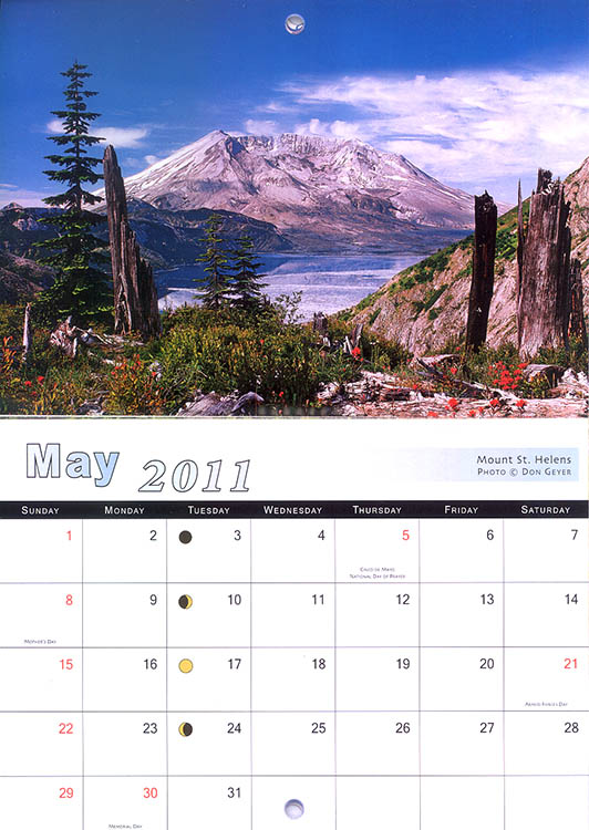
I have two images in this calendar. The first one is for the month of March and includes an image I took a couple years ago on a trip up to High Divide with my good friend David Crowe. It was a great trip and included one of the latest flower shows I've witnessed in the mountains. It was early September and the huckleberry plants were already turning red right along side the lupine, paintbrush and asters!

The second image appears the month of May. What mountain is synonymous with the month of May? Mount St. Helens of course!

This image is from a fantastic backpack I did with my dad a few years ago. It's actually a repeat image for the calendar, having appeared previously in their 2009 calendar. In fact, it also served as a cover image for the calendar, along with an image of mine of Mount Rainier!

These calendars will be available in most stores in Washington this fall for those interested in checking it out.

Changing the subject, I just finished packing and am heading to Death Valley in the morning. I'll be gone 1-1/2 weeks and hope to come back with some nice images to share.

Also, I haven't forgotten about my Yellowstone posts! I have at least two more to share and will do so upon my return. I promise!