Showing posts with label larches. Show all posts

Monday, November 7, 2022

Fall Colors Along the North Cascades Highway

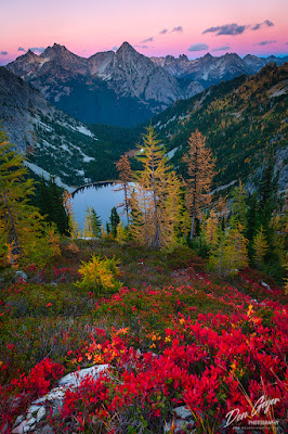
Image of Maple Pass, North Cascades
Lake Ann from below Maple Pass,
North Cascades.
Each year many people enjoy driving the North Cascades Scenic Highway in late fall to view the beautiful colors. This drive is beautiful any time of year but fall offers something a little more special.

The pinnacle of the fall colors may arguably be in the region of Rainy and Washington Pass in early October.  Here the larches turn golden and the berry plants at their feet a beautiful crimson red.  It's a sight to behold and one that keeps tourists coming back for more year after year.

For motorists out for a Sunday drive, the Washington Pass Overlook cannot be missed.  Just a short walk from the parking lot is the jaw-dropping, in your face view of Liberty Bell and its vertical north face with groves of golden larches just below its base.  If you are lucky, you can catch this monolith with a dusting of snow up top!

Silver Star Mountain and Kangaroo Ridge can also be viewed to the east, as well as Highway 20 steeply descending a swith-back below Early Winters Spires on its way down to the Methow Valley.

Image of Blue Lake and Liberty Bell
Blue Lake below Liberty Bell and 
Early Winters Spires.
For those willing to stretch their legs a bit, there are several hikes in the area that offer great rewards!  The easiest of which is Blue Lake near Washington Pass, with views of Liberty Bell and Early Winters Spires towering above the lake and colorful larches.  Don't be intimidated by the climbers hauling ropes and technical gear up the trail!  This is also the approach route for climbers wishing to tackle the various routes up these peaks.  But at a well-signed junction they take a hard left and begin their earnest climb to the base of these peaks, leaving you alone with your thoughts the rest of the way to the lake.  Don't forget to check out the tarn above!

More popular are trails west of Blue Lake at Washington Pass, as witnessed by the number of cars parked along the side of the road, sometimes for a mile or more on weekends.  These trails are right across from each other - Maple Pass to the south and Cutthroat Pass to the north along the PCT.

Maple Pass is by far the most popular of the two, though both are beautiful and offer incredible rewards.  It's a 6.5-mile loop trip with 1,800' elevation gain.  Or you can do a one-way in and out hike if you choose.  The culmination is the view in the first image above, as well as views deep into the North Cascades to the south.  One can also take a side trip to Wing Lake below Black Peak at a junction a saddle before the final climb to the pass.  Wing Lake is the only area that camping is legal - no camping at Maple Pass.
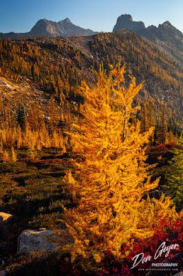
Image of Cutthroat Pass in Fall
Fall larches below Cutthroat Pass, with
Cutthroat Peak in the distance.
To the north is the final leg of the Pacific Crest Trail (PCT) for thru-hikers, starting from the Mexico border and hoping to finish before the snows start.  If you encounter grizzly looking backpackers, say hi - they might have many stories to share!

This trail climbs ever so gently to the open slopes of Cutthroat Pass - 10 miles, 1,960' elevation gain.  The views begin ~ 2 miles before the pass and may slow your pace substantially!  Gold and red dominate the landscape in season.  Camp sites are located above the pass, both north and south (they are dry - bring water).  The views are fantastic, especially of Silver Star Mountain and Kangaroo Ridge.  For even better views, walk an additional mile to Granite Pass with stunning views of Tower Mountain and Golden Horn, and yes, more larches!

If it can be arranged with two vehicles, one can make this a one-way trip by descending to the east down to Cutthroat Lake and eventually the trailhead at Cutthroat Creek - 10.5 miles.

Further west is the trailhead for Easy Pass which, though beautiful, is not that easy - gaining 2,800' in just 3.5 miles (7 miles round trip). But the views are spectacular at the narrow larch-covered saddle.  For better views, wander the meadows above the ridge and views out to Mount Logan in the heart of the North Cascades.
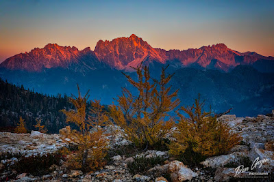
Image of Silver Star Mountain at Sunset
Sunset on Silver Star Mountain from Cutthroat Pass.
For other options a short distance away, consider checking out Twisp Pass and Stiletto Vista.  This requires driving down to the town of Twisp and turning onto the Twisp River Road and following it to the end.  The hike to the pass is 9
miles round trip, 2,400' elevation gain.  But you will want to continue on to Stilleto Vista a short distance above for the views down to Bridge Creek and across to Logan and Goode.  Larches abound and you can visit the former lookout site.

Nearby, approached by the same road is Copper Pass.  This is another fantastic larch destination in the fall but must be earned.  The trail gains 3,100' in just 5 miles.
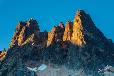
Image of Liberty Bell and Early Winters Spires
Early light on Liberty Bell and Early Winters Spires from
the Washington Pass Overlook.
For other ideas, consider driving up the Chewuch River Road out of Winthrop for many more hikes into larch country.  Don't miss checking out the Thirtymile Fire Memorial!

To view these images and many more of the North Cascades, please feel free to visit my North Cascades Gallery.

As always, thanks for looking and I hope to see you on the trail!

Saturday, May 30, 2020

Kootenay National Park In Autumn

Golden larch above Floe Lake and the Rockwall in Kootenay National Park, British Columbia, Canada
Golden larch in Kootenay National Park, British Columbia
Kootenay National Park resides on the British Columbia side of the Great Divide.  It neighbors Yoho National Park, Banff National Park, and Assiniboine Provincial Park.  It helps make up the four national parks and two provincial parks that are commonly simply referred to as "The Canadian Rockies".

The crown jewel of Kootenay National Park has to be Floe Lake beneath the backdrop of the magnificent Rockwall, especially as viewed from Numa Pass.  It's a popular destination for backpackers and permits can be difficult to come by.  But if one plans ahead, they are readily available and the rewards await.

Towards the end of September, the larch change into their glorious robe of gold, announcing the end of summer and the beginning of cooler days and chilly nights in the prelude to winter.  It's a magical time to be in the mountains.

This image is not the classic image of the area, but does capture the beautiful color of the larches above Floe Lake.  It currently is appearing in an editorial magazine in Taiwan.

If you wish to see more images from this area, you can view them in my Canadian Rockies Gallery.  I hope to have these images and more loaded to my new website soon.

Thanks for looking!

Thursday, April 20, 2017

Photographing Monica Meadows, Southern Purcell Range

 
Mount MacBeth above fall larches in Monica Meadows, Purcell Range, British Columbia, Canada.
Mount MacBeth above larches in Monica Meadows.
For many people, when they think of mountains in Canada it is typically the Canadian Rockies.  And why not?  They offer some of the most impressive scenery in the world and are one of my personal favorites as well.  What some people may not realize is that they have some pretty cool neighbors also competing for your attention.

The Purcell Range are a north-south trending range in British Columbia, just to the west of the Rocky Mountains of Canada.

A particularly famous section of the Purcells are the Bugaboos.  The Bugaboos are a spectacular collection of granite spires rising from massive icefields, and a world-renowned alpine rock climbing destination.  Bugaboo Provincial Park receives significant attention from the climbing, hiking and photography community, and is probably the most popular destination for visitors.  I wrote about my recent visit here.  Most other locations in the Purcells are far more remote and undeveloped, offering beauty and solitude to the adventurer willing to take on their challenge.


Mt. MacBeth above fall larches in Monica Meadows, Purcell Range, British Columbia, Canada.
Mount MacBeth above larches in Monica Meadows.
The biggest challenge can sometimes be road access.  Roads are subject to washouts and can take time to be repaired.  You should always check the latest conditions when planning you trip.  In the case of my visit to Monica Meadows, a bridge was washed out and only scheduled to be repaired toward the end of my trip to this region (maybe).  As it turned out, it was only repaired the day before my arrival.

Much of the Purcell Range can be accessed from Highway 95, which runs north-south along the Rocky Mountain Trench.  This highway runs parallel along the eastern side and offers many logging, mining and forest road access that extend deep into the heart of the Purcells.


Mt. Monica reflected in a tarn surrounded by fall larches in Monica Meadows, Purcell Range, British Columbia, Canada.
Mount Monica above a tarn in Monica Meadows.
On the west side of the range, access is more remote, and often requires ferry travel.  No worries, they're free and a fun experience!

Monica Meadows is such a place.  Located near Lardeau, BC, this fantastic destination competes with the likes of Jumbo Pass and MacBeth Icefields.  While the drive can be challenging some years, the trail is rather easy - 2.5 miles and 1,900' gain to some amazing meadows, especially in fall when the larches have turned golden.  This is typically toward the end of September.


Mt. Monica above fall larches and a lake in Monica Meadows, Purcell Range, British Columbia, Canada.
Mount Monica above a lake in Monica Meadows.
The drive to the trailhead is mostly on pretty good road.  However, some years it can get adventurous towards the end.  Especially with the bridge that is subject to washouts.

The views from the parking lot are amazing, and only get better as one begins up the trail.  After a series of steep switchbacks, the trail traverses around a ridge and into a basin where camping is available.  Please don't camp above this as this would scar the meadows.  Also, remember this is grizzly bear country and appropriate precautions should be taken.


Mt. Monica above fall larches and a lake in Monica Meadows, Purcell Range, British Columbia, Canada.
Mount Monica above a lake in Monica Meadows.
The meadows are beautiful and offer endless wandering.  If the larches are in season and you have camera in tow, progress along the trail will be slow.

At a junction, you can turn right to find a couple of lakes, or continue straight to pass a small lake before climbing to a ridge with incredible views west to Mt. MacBeth and other nearby peaks.  Of course, the view of Mt. Monica immediately before you is also nice.

Photographers:  While beautiful images can be had at any time of season here, I personally recommend fall.  The larch show is spectacular.  As with any destination, I recommend backpacking in to take full advantage of sunset and sunrise.  I was nursing a knee injury on this trip and was forced to limit myself to the weight of a day pack.  Wouldn't you know I missed one of the best sunrises of my entire trip!


Mt. MacBeth above fall larches and a lake in Monica Meadows, Purcell Range, British Columbia, Canada.
Mount MacBeth above a lake in Monica Meadows.
My predominant lens of choice was my 24-70mm.  I do not believe my 70-200mm ever left my pack.  I know my 17-40mm didn't.

GND filters are important to have, unless you plan on digitally blending back at the computer.

For the larches, this is an evening photography destination as there is a tall ridge directly to the east, blocking morning light.  However, light on Mt. MacBeth across the valley could be spectacular in the morning hours!

I hope to have these images added to my website soon.  As always, thanks for looking!

Thursday, October 17, 2013

A Challenging Fall in the Pacific Northwest

Ingalls Peak and fall larches from snow-covered
Headlight Basin in the Alpine Lakes Wilderness.
The snow came early to the mountains of the Pacific Northwest this year, making it more challenging to visit some of the more popular larch shows in our area.  Couple this with colors running late and the government shutdown closing all the national parks in our state, and it has been a test for even the most patient and understanding photographers and hikers.

Despite a run of nice weather over the last week or so, temps remain cool up high (as one would expect) and the snow does not appear to be going anywhere.  The usual suspect for displays of larch have only been available to those prepared for snow travel.  These destinations include:   Ingalls Lake, Enchantment Lakes, Lake Stuart and Horseshoe Lake, Carne Mountain, Cutthroat Pass, Snowy Lakes, Blue Lake, etc.

What do we have to look forward to?  According my weather forecasting friends, October is not supposed to see any storms this year.  While we might have some minor systems move through, the extended forecast is one of relatively nice weather.

There are many areas of bright fall colors remaining to be enjoyed lower down in the coming weeks, including along the Columbia River Gorge, the lower western slopes of the Cascades, Sol Duc, Crescent Lake and Dosewalips areas of Olympic NP, and if one is willing to put some miles under their wheels, the northeastern part of our state is always a great choice.

Wherever you elect to go, remember that hunting season is well underway and the wearing of bright colored clothing is highly recommended if hiking in areas with hunters present.

Good luck in your search for colors and hope to see you on the trail!

Thursday, December 6, 2012

Mount Assiniboine Image Usage

Mount Assiniboine above larches in fall.
I can't believe it has been exactly 1 month since I last posted here.  See, I told you things were busy!

Some of what has kept me busy has been the editing of images from multiple visits to the Canadian Rockies.  In July I spent considerable time around Lake Louise and along the Icefields Parkway in Banff National Park.

In late September I returned for backpacks to Berg Lake, Tonquin Valley, Floe Lake, and a visit to the Lake O'Hara area (I will be posting about these trips soon!).

Lake Magog in Assiniboine Provincial Park was to be my final backpack of this trip, but it did not happen.  The image above of Mount Assiniboine was taken during a previous visit.  This image was recently licensed for use in a retail book in Japan, appearing in a print run of 50K, and has been a popular image for me over the years.

I will be introducing a new Canadian Rockies gallery on my web site soon, which will include this image.  I know, I've said this before, but this time it is really going to happen!  Stay tuned...