Showing posts with label Canadian Rockies. Show all posts

Saturday, May 30, 2020

Kootenay National Park In Autumn

Golden larch above Floe Lake and the Rockwall in Kootenay National Park, British Columbia, Canada
Golden larch in Kootenay National Park, British Columbia
Kootenay National Park resides on the British Columbia side of the Great Divide.  It neighbors Yoho National Park, Banff National Park, and Assiniboine Provincial Park.  It helps make up the four national parks and two provincial parks that are commonly simply referred to as "The Canadian Rockies".

The crown jewel of Kootenay National Park has to be Floe Lake beneath the backdrop of the magnificent Rockwall, especially as viewed from Numa Pass.  It's a popular destination for backpackers and permits can be difficult to come by.  But if one plans ahead, they are readily available and the rewards await.

Towards the end of September, the larch change into their glorious robe of gold, announcing the end of summer and the beginning of cooler days and chilly nights in the prelude to winter.  It's a magical time to be in the mountains.

This image is not the classic image of the area, but does capture the beautiful color of the larches above Floe Lake.  It currently is appearing in an editorial magazine in Taiwan.

If you wish to see more images from this area, you can view them in my Canadian Rockies Gallery.  I hope to have these images and more loaded to my new website soon.

Thanks for looking!

Sunday, April 14, 2019

Mount Robson Provincial Park

Mount Robson reflected in Berg Lake, Mount Robson Provincial Park, British Columbia, Canada.
Mount Robson reflected in Berg Lake.
In my opinion, Berg Lake at the foot of Mount Robson in Mount Robson Provincial Park is one of the absolute highlights of the Canadian Rockies.  The Berg Glacier tumbles down from the uppermost reaches of the mountain, terminating at the side of the lake.  The constant rumbling you hear throughout the day and night (sometimes quite loud) is the ice from the glacier calving into the lake.  This classic view is just a few short steps from your tent site!

Much like Lake Magog in Mount Assiniboine Provincial Park, getting here involves a long hike in, or scheduling a helicopter ride on one of the two days a week they are allowed to land.

A base camp at Berg Lake offers several exceptional hiking opportunities to explore the area beyond the lake, including Mumm Basin, Hargreaves Glacier, Toboggan Falls and my favorite, Snowbird Pass.

This image is currently appearing on a tourism website.  You can see this image and many more from this area by visiting my Canadian Rockies Gallery.

As always, thanks for looking!

Saturday, April 6, 2019

Mount Assiniboine Provincial Park

Mount Assiniboine above fall larch near Lake Magog, Mount Assiniboine Provincial Park, British Columbia, Canada.
Mount Assiniboine above larch beginning to turn color.
I have been visiting Mount Assiniboine Provincial Park for many years now, and have come back with some of the most memorable experiences with each and every visit!  These memories include trudging through a foot plus of snow in September, mice infested cabins the one time I took my wife (our anniversary!), a mother grizzly bear and cub flattening my unattended tent, and more!  Yes, Assiniboine holds a special place in my heart.

This image was taken on my very first trip into Assiniboine.  It was mid-September and the larch had just started to turn.  It was a cold visit and we had it mostly to ourselves.  We packed in a tent with plans to stay in the campground, but arrived to find over a foot of snow on the ground and elected instead to stay in one of the Naiset Huts, which were mostly unoccupied and readily available.  Such would most likely not be the case today.  The huts are now reservable and booked well in advance.  Assiniboine has also seen a dramatic increase in popularity as more people are drawn to the "Matterhorn of the Canadian Rockies".

While popularity has gained, it still is nothing close to most national parks and I highly recommend a visit.  It's a 17 mile hike in, or helicopter flight, or tandem there of (including having your gear flown in while you do the hike).

For lodging, there is the campground, the Naiset Huts, or the Assiniboine Lodge itself!

This image is currently appearing in an internationally distributed wall calendar by a Japanese manufacturer.

To view more images from the Canadian Rockies - both National Parks and Provincial Parks, feel free to visit my Canadian Rockies Gallery.

As always, thanks for looking!


Wednesday, April 12, 2017

The Ramparts and Amethyst Lake

The Ramparts reflected in Amethyst Lake, Jasper National Park, Alberta, Canada.
Jasper National Park is the northernmost of the four famed national parks of the Canadian Rockies (the others being Yoho, Banff and Kootenay).  One of the most iconic settings in this park is The Ramparts above Amethyst Lake - truly a spectacular place to visit, especially in the fall.

Getting there is no easy task, however.  It requires a 12.7 mile backpack up the Astoria River, or a 14.2 mile and 2,400' climb over Mccarib Pass to get there.  I did the latter, as the Astoria River trail was closed due to washout.  It was a beautiful, but slow and tedious trek in on sore feet, having just hiked out from Berg Lake the previous day.  My feet were hamburger!

On this trip, I endured a grizzly bear swatting at my vehicle in the middle of the night as I slept at the trailhead, startling me out of a sound sleep.  The scratches from its claws can still be seen on the window of my vehicle.

I also had a cougar follow me back to my tent in the middle of the night after star photography, circle the tent, and then swat at it as I lay there silent with one hand on my headlamp and the other clutching my bear spray.  I didn't know it was a cougar until the following morning when saw its tracks, as there was also a pack of wolves in the area.

Some photos require a lot of hard work and perseverance just to get in position to be successful.  This is one of those images!  Fortunately, the images I captured from this area with have been quite successful for me.  This particular image was recently licensed for web use to a design and publishing firm in the UAE.

You can see more images from this area and more in my Canadian Rockies Gallery, if interested.

As always, thanks for looking!

Tuesday, January 31, 2017

Combining Fun with Fun!

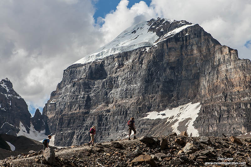
Hikers ascend the Plain of the Six Glaciers trail below Mount Victoria in Banff National Park, Alberta, Canada.
Hikers on the Plain of the Six Glaciers trail in Banff National Park.
My photography takes me all over the Western United States and Canada.  I love to travel.  In fact, these days I seem to do more hiking and photography out of state than I do within.  I guess I just enjoy searching out new destinations, and sometimes need a break from repeat local trips.

Travelling can have its negatives though, too.  It typically means I'm away from my family for extended periods of time while travelling alone.  Now that my kids are older and involved in competitive sports, it's can be very difficult to find a time when the entire family shares a window with nothing going.  But when it happens, it can be special!

I love being able to combine photography trips with a family vacation.  I know other photographers who shy away from this for various reasons.  But I have always been able to make it work without cheating either activity.  Shoot in the early mornings and evenings, and play with the family all day!  And if I can compose some images of the family in action, all the better!

This photograph from Banff National Park in Canada was taken during such an experience.  I believe I spent the morning at Moraine Lake for sunrise.  Then I went back to camp to my awaking family and we got ready for a day of hiking! 

This scene was captured along the Plain of Six Glaciers trail, above Lake Louise, with the steep face of Mount Victoria serving as the backdrop.  My daughter and I also scrambled up Fairview Mountain on this trip - her first 9,000' summit!  Can you tell I love the memories?

This image has been a popular one, and has been published multiple times.  It is currently being used by an editorial website in the media design & publishing sector.  But of course, what is most special to me is that my family is included!

If interested, you can view more images from this trip to the Canadian Rockies, and others, in my Canadian Rockies Gallery.  I hope you enjoy!

Tuesday, May 28, 2013

Photographing the Tonquin Valley

The Ramparts reflected in Amethyst Lake, Tonquin Valley, Jasper National Park, Alberta, Canada.
The Ramparts reflected in Amethyst Lake at dawn.
The Tonquin Valley is considered the jewel of Jasper National Park by many.  Located deep in the heart of the Canadian Rockies, the valley is famous for its dramatic scene of The Ramparts towering high above Amethyst Lakes, and casting their beautiful reflection into the lake’s calm waters at sunrise.  It is truly a sight to behold.

Of course, I must qualify the above description as being season dependent.  The Tonquin Valley is best visited in late season.  By late August, the bugs are gone and most of the “swampy” areas have dried up.  Visit in July and you will be swarmed by mosquitoes and horse flies beyond belief, likely requiring a head net and full clothing as you negotiate through bug hell.  Amethysts lakes can be difficult to approach in early season due to wetlands.  Trails can also be extremely muddy.

The Ramparts reflected in Amethyst Lake, Tonquin Valley, Jasper National Park, Alberta, Canada.
The Ramparts reflected in Amethyst Lake at sun
The valley is known for its abundance of wildlife, including caribou, cougars, wolves and grizzly bears.  During my visit, caribou were not present, while a new pack of wolves was.  It was widely believed that the wolves had migrated over from another valley, chasing the caribou away.  Fatal grizzly bear attacks have occurred in the Tonquin Valley in recent years.  While most hikers will not see a bear during their visit (I didn’t), it is very important to be prepared and aware while on the trail.


There are two approaches to the Tonquin Valley – the Astoria River trail and McCarib Pass trail.  Both are long.  While the Portal Creek Trail is longer (14.2 miles) and gains about 1,000’ more elevation as it climbs over McCarib Pass, it is much more scenic.  McCarib Pass is high, open country with views in all directions.  It should not be missed, even if it means a day hike from the lake to experience.  The Astoria River Trail is shorter (12.7 miles) and the quickest way into Amethyst Lakes.  I can’t compare the two trails because at the time of my visit, a massive slide off Mount Edith Cavell had closed the road to the trailhead, as well as the trail itself.

The Ramparts reflected in Amethyst Lake, Tonquin Valley, Jasper National Park, Alberta, Canada.
There are two prime campgrounds in the valley, Surprise Point Campground and Amethyst Campground.  Both are very scenic and offer excellent views of The Ramparts above Amethyst Lakes.  Amethyst Campground is more popular, and in my opinion, offering the better view and composition.  Nonetheless, I have seen beautiful images from Surprise Point as well.  Maybe you will need to visit both!

The Ramparts reflected in Amethyst Lake, Tonquin Valley, Jasper National Park, Alberta, Canada.
The Ramparts reflected in Amethyst Lake.
Morning is the time to photograph The Ramparts and their reflection in the lake.  Sunrise turns the rock bright pink, then gold as the morning progresses.  As long as the weather is stable, the water will be calm for the first few hours of the morning.
Getting to the lake from the Amethyst Campground can be tricky, outside the obvious trail from the campground.  This is because the rolling meadows are comprised mostly of wetlands.  For the most interesting foreground, I recommend hiking the main trail south for about ¼ mile, then aiming for the obvious rocks along the lakeshore.  This is a prime sunrise location to shoot from.

The Ramparts reflected in a tarn near Amethyst Lakes in Tonquin Valley, Jasper National Park, Alberta, Canada.
The Ramparts reflected in a tarn in Tonquin Valley.
By mid-morning the sunlight will begin to hit the meadows of the valley.  I recommend following the obvious trail from the campground to the lake as it passes several interesting rocks and tarns.

If staying at Sunrise Point, the area near the bridge entering the campground offers excellent foreground as rocks abound along the shore and in the shallow water.

The Tonquin Valley is best suited for wide-angle lenses.  My 17-40mm was my most used lens, with my 24-70mm coming in second.  I also hauled in my 70—200mm for wildlife, hoping to catch a grizzly bear or caribou.  My only grizzly encounter was at the trailhead parking lot the night before while I was sleeping.  As mentioned above, with the new presence of a wolf pack in the valley, the caribou are believed to have mostly left.  I probably would leave the large glass at home next time in consideration of the weight.
The Ramparts tower above Tonquin Valley in Jasper National Park, Alberta, Canada.
The Ramparts above Tonquin Valley.

You will want both a 2-stop and 3-stop GND filter.  I would also recommend a polarizer.  If you are into star photography, the Tonquin Valley is an excellent place for star shots as well as the Aurora Borealis (Northern Lights).  You might even have a wolf follow you back to your tent as I did!

If you are determined to carry heavy camera gear for your visit, there are pack guide services available that will haul your equipment for you for a fee.
I highly recommend spending a few days in the valley, with a full day on both sides for hiking in and hiking out.  Every morning offered different lighting and was a unique experience for me.  This also gives you time to further explore the area.
Enjoy your visit to this fantastic slice of heaven.  Life slows down here.  It’s okay to slow down with it.

To view more images of the area, visit my Canadian Rockies Gallery.

As always thanks for reading!

Saturday, January 12, 2013

New Canadian Rockies Gallery!

The Ramparts reflected in Amethyst Lake in Tonquin Valley.
I'm excited to announce the addition of my new Canadian Rockies Gallery to my Mountain Scenes web site!  I hope you enjoy viewing these fresh, new images.

It's been a long and tedious process, from editing the thousands of RAW images to final SEO web preparation and layout.  In fact, I forgot just how much work such a task involved!

The images represent Banff National Park, Jasper National Park, Kootenay National Park, Yoho National Park, Mount Assiniboine Provincial Park and Mount Robson Provincial Park. 

Hikers below Mount Victoria on Plain of Six Glaciers trail.
Included are images of Mount Assiniboine, Lake Magog, Mount Robson, Berg Lake, Lake Louise, Moraine Lake, Mount Victoria, Mount Temple, Tonquin Valley, Amethyst Lakes, The Ramparts, Lake O'Hara, Opabin Plateau, Peyto Lake, Castle Mountain, Floe Lake and Rockwall, and more.

I've enjoyed many trips to the Canadian Rockies over the years.  I have enjoyed them while car camping with family, dayhiking, backpacking, climbing and even canoeing.  Each one of these activities offers a different perspective and experience.  I recommend them all.

I hope you enjoy these new images.  All images are available as prints, as well as for commercial use.  I believe they would make an excellent addition to your walls, electronic presentation, or publication. 

As always, I welcome your comments or questions.  If you are planning a trip yourself, feel free to drop me an e-mail with any questions.  I am always happy to help.

Thank you for visiting.

Thursday, September 13, 2012

Photography Trip to Banff National Park


Ten Peaks above Moraine Lake, Banff National
Park.
The Canadian Rockies are comprised of four adjacent National Parks - Banff, Jasper, Kootenay, and Yoho - and a distant Waterton.  They also include several provincial parks, including Assiniboine, Hanber and Robson.  They are heaven north of the border and one of my all-time favorite destinations - one of Canada's true treasures.

Of all the parks, Banff is probably the most popular.  It offers a wide variety of attractions and photography possibilities; whether it's nature landscapes, manicured parks, man-made structures, people & wildlife,  or a combination of all the above.

I recently returned to this park after a lengthy hiatus and spent a week photographing throughout the park, even venturing into Yoho for a day.

It was a fantastic trip with mostly great weather.  It included summiting a 9,000' peak with my 9-year old daughter, several family hikes, lots of wildlife (including a grizzly bear near our campground) and photographing most of the major attractions of the park.

The peaks around Lake Louise reflected in Herbert Lake.
The most popular area in Banff National Park outside of the Banff town site is the Lake Louise vicinity.  Lake Louise and nearby Moraine Lake draw visitors by the thousands every day, and for good reason; the scenery is outstanding and both offer excellent hiking trails.  Parking can get crazy by late morning at both.

Mount Victoria, Mount Lefroy, Temple Peak and The Ten Peaks offer dramatic settings in the area, whether it is hiking to their base, climbing to their summits, or catching their reflection in a lake.

One of the beauties of this area for photographers, besides the scenery, is that the best time to photograph the area is in the early morning. So it is easy to beat the crowds. Arriving at both Moraine Lake and Lake Louise in the early dawn hours found me nearly alone as early light struck the nearby peaks.

The humorous thing I found about Lake Louise was that both mornings I spent photographing there was that the masses would show up just about the time I was packing up to leave. Visitors from the lodge came running down to the shore, often in their pajamas and bathrobes, and the tourist buses would start arriving in the parking lot.

Moraine Lake never produced such crowds during my visit.  Typically I would see a couple of other photographers during the prime light (arriving after me), and a few more would arrive before I packed up.  Returning mid-morning would find larger numbers, but nothing crazy.  The crazy numbers are found mid-day!


Hikers below Mount Victoria on the Plain of Six Glaciers
Trail.
 There are plenty of hikes to do in the area once you are finished capturing first light.  From Lake Louise, the Plain of Six Glaciers trail follows its north shore and climbs well above the lake to a prominent viewpoint of Mount Victoria.  There's even a tea house waiting for you near the end!

Another fun trail is to Saddleback on the opposite side of the lake.  The adventurous can scramble the final 1,500' to the summit of Fairview Mountain.

Paradise Valley is another popular destination, though bears can be a problem.  Such a warning was in place during our visit, requiring a group size of four or more.

Mount Temple above the Bow River.
Moraine Lake offers one of the best hikes in the area, especially in larch season (late September).  Larch Valley and Sentinel Pass are excellent destinations.  Again, group size restrictions can be in order due to bear activity, and were during our visit.

The Lake Louise Campground makes for an excellent base camp.  It is very close to both Lake Louise and Moraine Lake for easy and quick access, and is also centrally located to attractions further away.  The campground is alongside the Bow River, which affords excellent views of Mount Temple.  It is also located in prime grizzly bear habitat, necessitating an electric fence around it (it's not as obtrusive as it might sound).  The proof was in the pudding during our visit, as I returned to camp one morning to spot a mother grizzly grazing in an adjacent meadow.  As I later learned, she had two cubs.  I was not fortunate enough to see them.

I spent many evenings driving the Bow Valley Parkway between Lake Louise Village and Castle Mountain Junction.  This is probably one the best wildlife viewing areas in the park.  I photographed numerous black bears, bull elk, and the largest osprey nest I've ever seen, complete with young!


Castle Mountain above the Bow River.
 Of course, there is also Castle Mountain, which received pretty dramatic light most every evening as afternoon thunder storms cleared.  Most people seemed oblivious to this though as they were too occupied driving up and down the parkway in hopes of seeing a bear.

Near Castle Junction, several very large bull elk made daily appearances.  They were most likely to be seen in the evening, but not limited to.  They were quite a treat to see.


Peyto Lake along the Icefields Parkway.
The drive up the Icefields Parkway is not to be missed.  There are photography options every stretch of the way.  An entire day or more can easily be spent along this highway, especially if continuing all the way Jasper.

Peyto Lake is an often photographed lake along the parkway.  It requires a short but rather steep hike to the famous viewpoint, and you will not be alone at mid-day, which is considered the best time to photograph it.  I actually didn't have much luck at mid-day due to overcast skies and flat light.  The image here was taken in early morning as a storm crept in.

Bow Peak above Bow Lake along the Icefields Parkway.
 I was fortunate to time my visit during flower season, and was amazed at the flower show along the Icefields Parkway.  They lined the road as far as I ventured, and offered unlimited photography opportunities.  My favorite area was around Bow Lake.

On a day that cloudy skies and showers were forecast, we headed over to Yoho National Park and visited Takakkaw Falls.  Though Banff was mostly cloudy, Yoho offered us bluebird skies and pleasant hiking to the base of the falls.

Takakkaw Falls.
As I write this, I am packing and preparing for a return trip to the Canadian Rockies - leaving in just a couple of days.  This time, I will be spending two full weeks in the backcountry of Robson Provincial Park, Jasper National Park, Yoho National Park, Kootenay National Park and Assiniboine Provincial Park. 

Backpacking destinations will include Berg Lake (Robson), Tonquin Valley (Jasper), Floe Lake and the Rock Wall (Kootenay), Lake O'hara (Yoho) and Lake Maggog (Assiniboine). All but Tonquin Valley will be repeat visits for me.  My itinerary has me hiking 136 miles (not including side trips) with just under 10,000' gain during this time.

Upon my return I hope to have a lot of images to edit!  I also hope to edit my wildlife images from my previous trip, and to construct a new Canadian Rockies gallery on my web site.

Wish me luck!


Wednesday, July 18, 2012

Visiting the Canadian Rockies!

Mount Assiniboine Reflection
I'm excited to be leaving for the Canadian Rockies in just a few days!  While I won't be visiting Assiniboine Provincial Park on this trip (pictured), I will in a subsequent trip in late September.

I do plan to photograph throughout Banff National Park and possibly Jasper National Park as well.  The opportunities should abound and I am excited!

I have visited the Canadian Rockies on several occasions.  I have hiked and climbed in most of the national and provincial parks associated with them.  However, years have gone by since I last enjoyed visiting one of my very favorite places.  Redemption!

I will be focusing on Banff National Park for this trip, primarily areas around Lake Louise.  I hope to venture into Jasper, Yoho and Kootenay as well, but they will be limited.  My photography will be mostly roadside and short dayhikes.

In late September I will be returning to these very parks - and more!  I will be backpacking into Assiniboine and Mount Robson Provincial Parks, as well as Yoho, Kootenay and Jasper National Parks.  It should be an exciting season.  I hope to return with many new images to share!