Monday, August 24, 2020

High Divide, Olympic National Park

Mount Olympus above flower meadows on High Divide, Olympic National Park, Washington, USA.
Mount Olympus above flower meadows on High Divide.
I've been wanting to return to High Divide for a few years now.  Of course, permits for Heart Lake and Sol Duc Park were long taken.  But I was able to benefit from a timely release of walk-up permits made available online for Seven Lakes Basin, and acted quickly!

For where I wanted to photograph on High Divide, Seven Lakes Basin was not optimum.  But it beat descending with headlamp back to the car after evening photography!

I got an early 7:00 am start on the trail, after driving over from the Seattle area.  The ascent went pretty quickly, and is incredibly scenic once above Deer Lake as one climbs and traverses through parkland meadows.  Flowers were incredible, especially once gaining the ridge and traversing to the Seven Lakes Basin junction.

Early morning light on Lunch Lake in Seven Lakes Basin, Olympic National Park, Washington, USA.
Lunch Lake in Seven Lakes Basin.
The only difficulty on the trail is just before the junction where the trail has been wiped out due to a landslide, and one must follow cairns through a boulder field.  After a short climb to the notch, you are welcomed with a steep descent down to the lakes.

I spent most of the afternoon relaxing and enjoying the sun.  Around dinner time, I gathered my camera gear and headed up to the divide via the shortcut trail.

It was about 2 miles to my favorite flower meadow, pretty much overlooking Heart Lake.  It would be a headlamp jaunt back to camp and I was prepared.

The evening was enjoyable as I watch the sun set, casting pink alpenglow on the mountain.  Of course, this is followed with the Belt of Venus and the earth's shadow taking over the sky before the stars begin to appear.

Mount Olympus above flower meadows on High Divide, Olympic National Park, Washington, USA.
Mount Olympus above flower meadows on High Divide.
The trek back to camp in the dark half an hour after sunset wasn't as bad as I imagined.  In fact, my headlamp never left my pack as I was aided by the light of a quarter moon.

Then it was a late dinner and bed, with an everlasting grin on my face from another fantastic evening experience.

You can view more of my images from Olympic NP in my Olympic Gallery.

As always, thanks for looking!  Hope to see you on the trails!

Wednesday, August 19, 2020

Flowers At Mount Rainier!

Flower meadows along the Naches Peak loop trail at Mount Rainier National Park, Cascade Range, Washington, USA.
Flower meadows along the Naches Peak loop at
Mount Rainier National Park.
 If you sense some excitement in my prose, you would be correct!  Flower season in the mountains is so short, because the growing season is so short.  These meadows spend the majority of the year buried under a deep snowpack, and only get to come out to play for a couple months out of the entire year! Different varieties of flowers can have different schedules.  Some years these schedules match for the most part, some years they do not. So when everything starts coming together it is reason to get excited!

At Mount Rainier, the flower show arrived a couple weeks ago in typical fashion - by beginning their tour on the east side of the park around Tipsoo Lake and Sunrise.  While these areas are no longer in peak, others are!  Try a hike up to Spray Park or Indian Henry's Hunting Ground or simply enjoy a short walk/hike around Paradise or Mazama Ridge.  Now is the perfect time!

Please remember to be respectful of the meadows.  The growing season is so short that even the lightest of tread can cause irreparable damage.  As my kid's patches used to say (handed out by the National Park Service), "Don't Be A Flower Stomper!"

This year is even crazier than most.  I spent a weekend morning at Sunrise photographing a couple weeks ago.  When I arrived back at the parking lot shortly after 7 am, it was already full.  By 8:30 am, the entrance was already closed and there were cars lined up for a quarter of a mile!  (By comparison, I came up the very next day - a weekday, and it was quite the opposite).  With this increase in traffic comes an increase of pressure on such fragile environments, which we all should be cognizant of.

Flower meadows along the Naches Peak loop trail in Mount Rainier National Park, Cascade Range, Washington, USA.
Flower meadows at Mount Rainier.
This is not unique to our area.  It's happening all over.  I just returned from the Sawtooth Wilderness in Idaho and experienced much the same.  A shuttle service I used told me he had never seen such crowds in all the years he has been in the area.  His thoughts were that it was the culmination of cabin fever and not being able to travel.  I can't say that I can argue with his assessment.

Anyway, back to the flowers!  Lupine, paintbrush, asters, common cow parsnip, false hellebore, and so much more!  Or, maybe you know them as the red ones, purple ones, yellow ones - that's alright too!  The importance is the enjoyment!

If you would like to see more images from this area, feel free to visit my Mount Rainier Gallery.

As always, thanks for looking!


Monday, August 17, 2020

The Crazy Year We Call 2020!

This has been a year unlike any I can remember in recent times.  I've been planning to update my blog for about four months now, but have just been so busy.  My plans and intentions have been there.  I enjoyed some excellent photography trips in May and June, mostly shooting waterfalls on the east side of Mount Rainier.  They were excellent trips that I was very excited to share.  But alas, before I knew it time fast-forwarded to a new month and such a trip was no longer relevant to the times.  This is how this year has seemed to go for me!

So, I thought I would take a moment to simply update you on what has/is happening in my life and move on from there.

Of course, the elephant in the room is COVID-19.  I think this pandemic has changed the lives of just about everyone of us in a major way.  So many things that we have taken for granted in our everyday lives are no longer such.  We are living in different times now for sure.

On the home front, I have two teenage kids who I am extremely proud of.  My daughter is a senior in high school and is spending most of her time applying to colleges.  Our plan was to set time aside to go visit various campuses, but those times have passed.  Now its virtual online tours.  Sigh.

My son is a freshman in high school and just coming off ACL surgery. While doing so, he somehow found a way to break his Tibia while jumping into the air to try and dunk a basketball.  I had never heard of such a thing.  He has it all on video.  His friend was documenting the moment.  The result was immediate surgery to screw it back together.  He is now enjoying the fun of rehab all over again.  I suppose he couldn't have picked a better time with most select sports being cancelled.

Beside all these fatherly responsibilities, I have indeed been finding time to get out!  I've enjoyed photography trips to Mount Rainier NP, Olympic NP and even the Sawtooth Wilderness in Idaho - my first venture into this fantastic mountain range!  I also have many more adventures planned in the coming weeks.

I'm excited to be able to share all these magnificent trips with you in the coming days and weeks ahead.

I hope you are finding time to get out and staying safe as well.


Saturday, May 30, 2020

Kootenay National Park In Autumn

Golden larch above Floe Lake and the Rockwall in Kootenay National Park, British Columbia, Canada
Golden larch in Kootenay National Park, British Columbia
Kootenay National Park resides on the British Columbia side of the Great Divide.  It neighbors Yoho National Park, Banff National Park, and Assiniboine Provincial Park.  It helps make up the four national parks and two provincial parks that are commonly simply referred to as "The Canadian Rockies".

The crown jewel of Kootenay National Park has to be Floe Lake beneath the backdrop of the magnificent Rockwall, especially as viewed from Numa Pass.  It's a popular destination for backpackers and permits can be difficult to come by.  But if one plans ahead, they are readily available and the rewards await.

Towards the end of September, the larch change into their glorious robe of gold, announcing the end of summer and the beginning of cooler days and chilly nights in the prelude to winter.  It's a magical time to be in the mountains.

This image is not the classic image of the area, but does capture the beautiful color of the larches above Floe Lake.  It currently is appearing in an editorial magazine in Taiwan.

If you wish to see more images from this area, you can view them in my Canadian Rockies Gallery.  I hope to have these images and more loaded to my new website soon.

Thanks for looking!

Monday, May 25, 2020

A Treasure in the Buckhorn Wilderness

A waterfall along the Quilcene Riverl in the Buckhorn Wilderness, Olympic National Forest, Washington, USA.
Waterfall along the Quilcene River.
I recently revisited one of my favorite drainages of the entire Olympic peninsula in Washington State - the Quilcene River.  This drainage resides on the east side of the peninsula and sports a beautiful rain forest along a the very scenic waters of the Quilcene.

While the Big Quilcene trail is a popular route to Marmot Pass and Buckhorn Mountain (as well as longer backpacks), much beauty can be enjoyed along the first couple of miles as the trail follows the river through rich, lush forest. The greens of the moss, ferns and lichen really pop on a cloudy day and accentuate the powerful, turbulent waters of the Quilcene River and its side tributaries.

A waterfall along the Quilcene Riverl in the Buckhorn Wilderness, Olympic National Forest, Washington, USA.
Waterfall along the Quilcene River.
The river thunders loudly for much of the journey.  The trail is sometimes close to its banks, sometimes high above with a perch-type view.  Many side tributaries add to the beauty in early season, especially when the high country is still covered in snow.

The air always seems so fresh along this stretch of trail, especially on a slightly rainy day like I most recently had.

For photography, my favorite time to visit this area is in May or early June, and preferably on a cloudy day.  If you are awarded a bit of drizzle during your journey, bonus!

Shelter River camp marks the point the trail leaves the river behind and begins the steep climb up to Mystery Camp and Marmot Pass.  For photographers, the best opportunities are well before Shelter Camp as the forest begins to open up by here.

For those wishing to stretch their legs after a morning of photography, by all means - continue on!  The trail climbs steeply to the wonderful panorama westward at Marmot Pass, looking out to Mt. Mystery and Mt. Deception (second highest peak in the Olympics).

A waterfall along the Quilcene Riverl in the Buckhorn Wilderness, Olympic National Forest, Washington, USA.
Waterfall along the Quilcene River.
For even better views, continue another 1.5 miles towards Buckhorn Pass and find a well-worn path that leads to the west summit of Buckhorn Mountain.  The close-up views of Warrior Peak and Mt. Constance are impressive, as are the views north to the Straight of Juan de Fuca.

Fun photography can be had at these heights as well for those willing to carry their gear up this high.

A waterfall along the Quilcene Riverl in the Buckhorn Wilderness, Olympic National Forest, Washington, USA.
Waterfall on a tributary along the Quilcene River.
Back to the forest photography down low - you know, what this post was originally about before the squirrel ran by?  I recommend a mid-range lens and polarizer filter to bring out the lush greens of the of the forest carpet and canopy.  As long as you are visiting on a cloudy day, a neutral density filter shouldn't be necessary, but it would never hurt to have it with you.

Bring rain gear.  Even when it is not raining, this area stays pretty moist in early season and brushing against ferns or tree limbs or sitting down will get you wet.

Be sure to walk slow and have your head on swivel through the forest section.  Opportunities are numerous and easy to miss.  In fact, you will be likely to see ones on your return trip that you missed on the way up.  After numerous visits to this area, I still do.

Most importantly, remember to enjoy this beautiful place and all it has to offer!

As always, thanks for looking.  You can see more images from this area and Olympic National Park, please visit my Olympic Gallery.


Saturday, November 16, 2019

NEW 2020 Wall Calendars!

 I'm excited to announce my NEW 2020 wall calendars!  I've been working feverishly on these for some time now, and am very happy with the results!

The first one is my Western Landscapes calendar.  It includes images from all over the western U.S. and Canada, including Bryce NP, Bugaboo PP, Glacier NP, Grand Canyon NP, Mount Rainier NP, Redwoods NP, Mount Robson PP, Mount St. Helens NM, Yellowstone NP, Yosemite NP and more!

The second one is from my home state - Mount Rainier! It includes images from throughout Mount Rainier National Park including, Paradise, Mazama Ridge, Spray Park, Emerald Ridge, Christine Falls, Tatoosh Range and more!

You can now order these calendars online in time for the holidays!  I hope you find these calendars as fun to look at as I did making them!

As always, thanks for looking!

Sunday, November 10, 2019

Columbia River Gorge, After the Fire

Multnomah Falls amidst fall colors in the Columbia River Gorge National Scenic Area, Oregon, USA.
Multnomah Falls
I recently visited the Columbia River Gorge National Scenic Area this fall for the first time since the horrendous Eagle Creek Fire.

The Eagle Creek Fire was started in September 2, 2017 by a 15-year old boy lighting fireworks during a well-broadcast burn ban.  The fire took off at an unbelievable clip.  The fire was reported at 4:00 pm on this day, and by the next morning it had already burned over 3,000 acres.  On September 5th, it actually jumped the Columbia River into Washington near Archer Mountain!  153 hikers were trapped in the backcountry, 6 miles up the trail.  When all was said and done, the fire had burned over 50,000 acres and took three months to finally contain.  It would have consumed Multnomah Lodge if it weren't for fire tenders.  The damage was devastating.

I really wasn't sure what to expect.  Though a totally different event, in my head I was expecting the same type of recovery as Mount St. Helens National Volcanic Monument after the eruptions.  To a large degree, I think this is true - at a much quicker pace due to the lower elevation.

Latourell Falls amidst fall colors in the Columbia River Gorge National Scenic Area, Oregon, USA.
Latourell Falls
In some places, if one is unsuspecting, it can be hard to see the signs of the fire.  In other places, not so much.  The underbrush has grown back quickly.  But the charred stumps still remain.  Trees that are continuing to thrive have the black scars on their lower half to remind them of the ill-fated event, yet proudly display their resiliency.

The signs are first noticed while driving along the scenic highway.  Fences that were not previously present have been erected above the road to catch any debris that may come skidding down the mountainside.

The trail from the lower Multnomah viewpoint up to the Benson Bridge has such fencing immediately above the trail.  Signs of the burn are everywhere, including very uncomfortably close to the lodge.  Along this trail are signs of darker times, as well as hope.  Many trees are charred on their lower half, yet stand stoically with their full health up high.  Other trees weren't as lucky.

The good news for people wishing to visit this area is that most of the waterfalls I visited are not affected for photography or simply enjoying from the traditional observation areas.  Of all the waterfalls I visited, only Wahkeena saddened me to sea a large charred stump at the based of the falls, much too large to disappear anytime soon through the course of nature.

Latourell Falls amidst fall colors in the Columbia River Gorge National Scenic Area, Oregon, USA.
Latourell Falls
The bottom line is that the Columbia River Gorge National Scenic Area is still a very beautiful place to visit.  Don't put it off!

To see more images from this area, be sure to visit my Columbia River Gorge Gallery at www.mountainscenes.com.

As always, thanks for looking!  Hope to see you on the trail!


Friday, September 27, 2019

Island in the Sky, Canyonlands National Park

Murphy Point and Soda Springs Basin from the Green River Viewpoint in Canyonlands National Park, Utah.
Murphy Point and Soda Springs Basin from the Green River Viewpoint in 
Canyonlands National Park.
Created in 1964, Canyonlands National Park attracts recreationists from all over the world.  It's not hard to understand why.  The park is divided into three districts - Island in the Sky, the Needles, and the Maze.  Each one is vastly different from the others and offers its own unique flavor.

Island in the Sky is the most accessible unit of the park, with a paved 34-mile scenic road leading to incredible views such as that pictured here near road end.  Grand View Point and Green River Overlook are incredible places to witness sunrise and sunset on the canyon walls overlooking the Colorado and Green rivers.

This image was taken from the Green River Viewpoint near sunset, just a short walk from my campsite in Willow Flat.  It was recently licensed for a local travel brochure promoting outdoor recreation, the area's primary industry.

You can view more images from this awe-inspiring area by visiting my Southwest Gallery.

As always, thanks for looking!

Sunday, September 8, 2019

Panhandle Gap, Mount Rainier National Park

Mount Rainier from below Panhandle Gap on the Wonderland Trail in Mount Rainier National Park, Cascade Range, Washington, USA.
Mt. Rainier from below Panhandle Gap in Mount Rainier National Park.
The highest and most desolate section of the Wonderland Trail resides on the east side of Mount Rainier National Park, above Summerland.  Panhandle Gap is the official high point at 6,750', separating Summerland from remote Ohanapecosh Park.

The trail begins at Fryingpan Creek, where parking can be challenging by mid-day.  This popular trail is gradual for the first two miles before climbing up to a crossing of the creek at 3 miles.  Then is a mile of mostly short, steep switchbacks to Summerland.  There are campsites here and a stone shelter cabin with views of the mountain.

For Panhandle Gap, continue on by descending to the creek crossing and then climbing up, first thru alpine meadows, then thru rough moraine often marked by cairns to a couple high tarns, then a further climb to Panhandle Gap.  The views are glorious all the way.

From the gap, the trail can be followed south as it gently descends into and traverses Ohanapecosh Park.  This area offers wide open wandering for the curious.

For photographers, this trail can be challenging as much of Rainier is obscured from this side, and the desolate nature of the area doesn't necessarily offer a lot of interesting foreground material to put in front of the mountain.  The image above was taken just below Panhandle Gap, and is probably the first interesting view of the mountain in my opinion.  My recommendation?  From Panhandle Gap a path can be followed east as it traverses east along a ridge and descends into parkland, where one can wander open slopes up to a high point with unobstructed views of the mountain.

Bears are commonly seen in the Summerland area in early season, and mountain goats can be encountered throughout the hiking season.  Marmots are also present in Summerland as well as Ohanapecosh Park.  The big glass could come in handy if you so choose.

For landscape photography, my preference is the 24-70mm.

To view more images from Mount Rainier National Park, please visit my Mount Rainier Gallery.

As always, thanks for looking!  Hope to see you on the trail!


Thursday, August 8, 2019

Indian Henry's Hunting Ground, Mount Rainier

Mount Rainier reflected in a tarn in Indian Henry's Hunting Ground in Mount Rainier National Park, Cascade Range, Washington, USA.
Indian Henry was the adopted English name of So-To-Lick, a Klickitat or Yakima according to many tales.  He crossed the Cascade Mountains to call the Mashel Prairie home in 1864, living amongst the Mashel bands, who were thought to be a mix of Nisqually and Klickitat descent.

Henry was known as an excellent woodsman and guide, and gained fame by guiding at least one party attempting to summit Mt. Rainier.  Henry regarded the mountain as sacred and would not attempt the summit himself.  He considered ascending the glaciers to be bad luck.  But he would lead them as far as he could and watch their horses and belongings for them while they climbed.

A patrol cabin was built here in 1915 - 1916, and is still used by park staff patrolling the backcountry.  It seems to lend itself well to the area, offering a sense of history, and its front porch offering a destination for many, wishing for a place to enjoy their lunch or munch on the numerous huckleberries in the area in season.

Today Henry is most remembered by one of his most beloved destinations on the southwest slopes of Mt. Rainier, Indian Henry's Hunting Ground.  This picturesque setting is one of the most scenic areas of the park, offering breathtaking reflections, flowers in the summer, and bright red and orange colors in autumn.  It can even be a fantastic snowshoe trip in the winter for experienced winter travelers!

This reflection scene amongst the flowers of Indian Henry's Hunting Ground embraces the beauty of the park unlike any other, in my opinion.  It's a favorite of mine, and I'm proud to say that this particular image is currently appearing in a local travel magazine in my state of Washington.  I hope others enjoy it as well.

Hope to see you on the trail!

Sunday, July 28, 2019

Cascade Pass and Sahale High Camp

Sahale Peak above a rushing stream at a high camp in North Cascades National Park, Washington, USA.
Sahale Peak above rushing stream.
Cascade Pass is one of the most beautiful hikes in North Cascades National Park.  The views actually start right from the parking lot!  It's also known as one of the most historic passes.  Originally known as Skagit Pass  by some, it was originally used by Indians and later, explorers.

Today it is quite popular amongst hikers, backpackers and climbers, and one should not expect solitude.  Hikers enjoy the incredible views from the pass itself, and even continue up Sahale Arm, where the views get even more superlative with each step.

Backpackers continue up Sahale Arm to Sahale High Camp at 7,600' (a 4,000' ascent from the parking lot), or as a starting point for a much longer trek down thru Pelton Basin and Cottonwood Camp (former road end from Stehekin) to Stehekin or up to Park Creek Pass and out Thunder Creek to Highway 20.

Climbers use Cascade Pass as a starting point for the incredible Ptarmigan Traverse, traversing the crest of the Cascades south to Dome Peak and exiting via Downey Creek.  They also use it to climb the peaks in the immediate vicinity of the pass, such as Sahale Peak or Mount Buckner.

View from high camp in North Cascades National Park looking south along the Cascade crest, Washington, USA.
View from Sahale High Camp in North Cascades.
I've enjoyed all these trips mentioned and would be hard pressed to pick a favorite.  Each one offers something special and unique.

For this trip, I had my sights set on Sahale High Camp, and if my recovering injuries allowed, Sahale Peak.

I got an 8:30 am start at the TH and worked my way up the reported 33 switchbacks to the pass, arriving at 10:00.  After a brief break, it was up the trail to Sahale Arm and eventually, Sahale High Camp, arriving just after noon.
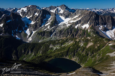
Doubtful Lake and North Cascades from Sahale High Camp in North Cascades National Park, Washington, USA.
Doubtful Lake and North Cascades from Sahale High Camp.
The views were as incredible as I remembered them.  I was the first overnighter to arrive, so I had my pick of campsites.  I quickly chose my home for the evening, pictured above.  Yep, that's my tent!

As the afternoon wore on, more people began to show up and the place filled up by evening.

I was also visited by a mother goat and her kid, looking for salt deposits.  Eventually I would learn there were actually two different mothers and kids!

I enjoyed evening photography from a rock bluff just above camp, then returned to my tent for the evening.
Stars and the Milky Way above the North Cascades.

I set my alarm for midnight and awoke to do some night photography and hopefully, capture the Milky Way.  As I set up my camera, I was surprised to look down and see several headlamps coming up!  Who the heck would be coming up this hour?  Following the now cairned route (no trail) would be very difficult in the dark.  I returned to my tent and waited for them to arrive and get settled before I continued night photography.

The group wandered around for a considerable amount of time, likely struggling to find an open site.  It took about an hour for the headlamps to stop lighting up my tent, and I got up and continued my photography.

View from Sahale High Camp at dawn, North Cascades National Park, Washington, USA.
View of North Cascades at dawn.
I then set my alarm for 4:30 am to catch sunrise and tried to get a couple hours more sleep.

Dawn is a time of tranquility and peacefulness, and is my favorite time to photograph.  Usually I am alone or nearly alone, but I was surprised how many others also rose at the early hour simply to experience it for themselves.  I'm pretty sure they enjoyed it as much as I did.

I usually start photographing about 1/2 an hour before sunrise, sometimes more.  These early shots usually turn out to be my favorite.

View of the North Cascades at dawn from Sahale High Camp, North Cascades National Park, Washington, USA.
North Cascades at dawn from Sahale High Camp.
Soon first light began hitting Dome Peak in the distance (snow cap) and shortly thereafter the peaks in front me.  I watched the shadows begin to grow darker and creep down the mountain sides, drawing an end to my early morning photography due to the increased contrast and ever growing harsher light.

I retreated back to my campsite for some coffee and breakfast, and deliberated how to spend the remainder of the day.  I had a permit for a second night, but was strongly leaning toward descending.  My legs didn't have Sahale Peak in them, so it would simply be another leisurely day around camp.  I made the decision to descend after waiting for light to hit Doubtful Lake for one last photo opportunity.

View of North Cascades at dawn from Sahale High Camp, North Cascades National Park, Washington, USA.
North Cascades at dawn from Sahale High Camp.
While packing, I notice a couple descending the route below very slowly and surmised they must be having a problem.

By 8:00 am I was packed up and ready to go, and was nearly the last to leave camp.

About 3/4 of the way down the moraine I came upon the couple I had seen from above.  Sure enough, one of them was "butt scooting" down the path, which meant he was injured.  His ankle had been wrapped in foam and immobilized.  A rock had rolled out from underneath his foot, and he had turned it badly.  I asked if there was anything I could help with, to learn that the woman with him was with the park service, and was actually the same woman who had issued me my permit!  She assured me that more park service people were on their way up with a litter.

Sunrise on North Cascades, viewed from Sahale High Camp in North Cascades National Park, Washington, USA.
Sunrise on North Cascades, viewed from Sahale High Camp.
I wished them the best and continued on my way.  As I descended near the pass, I passed another park service employee on her way up with crutches strapped to her pack.  Sahale Arm is not a place for crutches, and it left me scratching my head how they could possibly make that work.  I spoke with her briefly before descending to the pass.

I arrived to find the large guided group gathered that had camped next to me.  I learned that the injured hiker was actually their guide, and that the injury had not taken place during his descent, but rather the previous afternoon above camp!  The headlamps I saw at midnight were actually his replacement and park service members coming up to help!  Things were now making a lot more sense.

Doubtful Lake and Mt. Formidable from Sahale High Camp, North Cascades National Park, Washington, USA.
Doubtful Lake and Mt. Formidable.
I also learned that as a result of the ranger presence at camp, the idiot flying his drone around was indeed cited.  That's another story!

I continued my descent down to the car, expecting to pass the litter carrying party at every bend.  I was nearly to the parking lot before I reached them.  It was going to be a long day for all involved and I hope the outcome was a good one. Having had Mountain Oriented First Aid (MOFA) training and helping out on a rescue near Leavenworth, I can tell you that getting a litter down a trail can be a long, slow process.

Photo Advise:

This is a weight sensitive trip due to the elevation gain and steepness of the trail (especially towards the top).  Having learned that a couple bears and the goats had been reported in the area, I brought my "bear lens" and 2x teleconverter.  But when it was time to decide on whether to pack it in, I said heck no - not worth it.

My lens of choice was my 24-70mm, and my 14mm Rokinon wide angle for night photography.  These would be my recommendations.

There are lots of flora options near Cascade Pass and Sahale Arm, with lots of potential of putting peaks behind them in your composition.  Above the meadows, it's just moraine up to camp and a world of rock and ice.

I hope this report helps in your own planning.  Feel free to contact me with any questions.  Always happy to help!

If you wish to see more images from this area, please feel free to visit my North Cascades Gallery.

See you on the trail!


Sunday, April 14, 2019

Mount Robson Provincial Park

Mount Robson reflected in Berg Lake, Mount Robson Provincial Park, British Columbia, Canada.
Mount Robson reflected in Berg Lake.
In my opinion, Berg Lake at the foot of Mount Robson in Mount Robson Provincial Park is one of the absolute highlights of the Canadian Rockies.  The Berg Glacier tumbles down from the uppermost reaches of the mountain, terminating at the side of the lake.  The constant rumbling you hear throughout the day and night (sometimes quite loud) is the ice from the glacier calving into the lake.  This classic view is just a few short steps from your tent site!

Much like Lake Magog in Mount Assiniboine Provincial Park, getting here involves a long hike in, or scheduling a helicopter ride on one of the two days a week they are allowed to land.

A base camp at Berg Lake offers several exceptional hiking opportunities to explore the area beyond the lake, including Mumm Basin, Hargreaves Glacier, Toboggan Falls and my favorite, Snowbird Pass.

This image is currently appearing on a tourism website.  You can see this image and many more from this area by visiting my Canadian Rockies Gallery.

As always, thanks for looking!